Hamlin, Kansas
| Hamlin, Kansas | |
|---|---|
| City | |
 Location within Brown County and Kansas | |
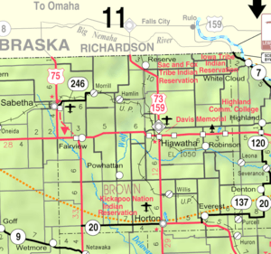 KDOT map of Brown County (legend) | |
| Coordinates: 39°54′58″N 95°37′39″W / 39.91611°N 95.62750°WCoordinates: 39°54′58″N 95°37′39″W / 39.91611°N 95.62750°W | |
| Country | United States |
| State | Kansas |
| County | Brown |
| Area[1] | |
| • Total | 0.09 sq mi (0.23 km2) |
| • Land | 0.09 sq mi (0.23 km2) |
| • Water | 0 sq mi (0 km2) |
| Elevation | 991 ft (302 m) |
| Population (2010)[2] | |
| • Total | 46 |
| • Estimate (2012[3]) | 46 |
| • Density | 510/sq mi (200/km2) |
| Time zone | Central (CST) (UTC-6) |
| • Summer (DST) | CDT (UTC-5) |
| FIPS code | 20-29700 [4] |
| GNIS feature ID | 0472770 [5] |
Hamlin is a city in Brown County, Kansas, United States. As of the 2010 census, the city population was 46.[6]
History
Hamlin was laid out in 1870.[7][8] It was named in honor of Hannibal Hamlin, Abraham Lincoln's vice-president.[9][10]
Geography
Hamlin is located at 39°54′58″N 95°37′39″W / 39.91611°N 95.62750°W (39.916094, -95.627632).[11] According to the United States Census Bureau, the city has a total area of 0.09 square miles (0.23 km2), all of it land.[1]
Demographics
| Historical population | |||
|---|---|---|---|
| Census | Pop. | %± | |
| 1880 | 135 | — | |
| 1890 | 216 | 60.0% | |
| 1900 | 258 | 19.4% | |
| 1910 | 208 | −19.4% | |
| 1920 | 211 | 1.4% | |
| 1930 | 183 | −13.3% | |
| 1940 | 174 | −4.9% | |
| 1950 | 118 | −32.2% | |
| 1960 | 99 | −16.1% | |
| 1970 | 95 | −4.0% | |
| 1980 | 80 | −15.8% | |
| 1990 | 50 | −37.5% | |
| 2000 | 53 | 6.0% | |
| 2010 | 46 | −13.2% | |
| Est. 2015 | 45 | [12] | −2.2% |
| U.S. Decennial Census | |||
2010 census
As of the census[2] of 2010, there were 46 people, 19 households, and 13 families residing in the city. The population density was 511.1 inhabitants per square mile (197.3/km2). There were 24 housing units at an average density of 266.7 per square mile (103.0/km2). The racial makeup of the city was 95.7% White, 2.2% African American, and 2.2% from other races. Hispanic or Latino of any race were 8.7% of the population.
There were 19 households of which 26.3% had children under the age of 18 living with them, 57.9% were married couples living together, 5.3% had a female householder with no husband present, 5.3% had a male householder with no wife present, and 31.6% were non-families. 31.6% of all households were made up of individuals and 5.3% had someone living alone who was 65 years of age or older. The average household size was 2.42 and the average family size was 3.00.
The median age in the city was 44 years. 23.9% of residents were under the age of 18; 2.1% were between the ages of 18 and 24; 28.3% were from 25 to 44; 26% were from 45 to 64; and 19.6% were 65 years of age or older. The gender makeup of the city was 56.5% male and 43.5% female.
2000 census
As of the census[4] of 2000, there were 53 people, 19 households, and 15 families residing in the city. The population density was 538.3 people per square mile (204.6/km²). There were 26 housing units at an average density of 264.1 per square mile (100.4/km²). The racial makeup of the city was 100.00% White.
There were 19 households out of which 42.1% had children under the age of 18 living with them, 52.6% were married couples living together, 31.6% had a female householder with no husband present, and 15.8% were non-families. 15.8% of all households were made up of individuals and 5.3% had someone living alone who was 65 years of age or older. The average household size was 2.79 and the average family size was 3.06.
In the city the population was spread out with 32.1% under the age of 18, 32.1% from 25 to 44, 15.1% from 45 to 64, and 20.8% who were 65 years of age or older. The median age was 36 years. For every 100 females there were 96.3 males. For every 100 females age 18 and over, there were 89.5 males.
The median income for a household in the city was $27,500, and the median income for a family was $34,375. Males had a median income of $18,750 versus $46,250 for females. The per capita income for the city was $14,813. None of the population and none of the families were below the poverty line.
Notable people
- Ellen Palmer Allerton (1835-1893), Walls of Corn poet, interred at Hamlin Cemetery[13]
- Charles Scott Berry (1875-1960), noted educator[14][15]
- Lucian Cary (1886-1971), novelist, short story writer, editor and firearms expert[16]
- Warren J. Fretz, (1877-1945), U. S. Bureau of Animal Industry inspector-in-charge of veterinary field work in Minnesota[17][18]
References
- 1 2 "US Gazetteer files 2010". United States Census Bureau. Retrieved 2012-07-06.
- 1 2 "American FactFinder". United States Census Bureau. Retrieved 2012-07-06.
- ↑ "Population Estimates". United States Census Bureau. Retrieved 2013-05-29.
- 1 2 "American FactFinder". United States Census Bureau. Retrieved 2008-01-31.
- ↑ "US Board on Geographic Names". United States Geological Survey. 2007-10-25. Retrieved 2008-01-31.
- ↑ "2010 City Population and Housing Occupancy Status". U.S. Census Bureau. Retrieved April 9, 2012.
- ↑ Blackmar, Frank Wilson (1912). Kansas: A Cyclopedia of State History, Embracing Events, Institutions, Industries, Counties, Cities, Towns, Prominent Persons, Etc. Standard Publishing Company. p. 805.
- ↑ Kansas State Historical Society (1916). Biennial Report of the Board of Directors of the Kansas State Historical Society. Kansas State Printing Plant. p. 149.
- ↑ Kansas Place-Names,John Rydjord, University of Oklahoma Press, 1972, p. 330 ISBN 0-8061-0994-7
- ↑ Gannett, Henry (1905). The Origin of Certain Place Names in the United States. Govt. Print. Off. p. 148.
- ↑ "US Gazetteer files: 2010, 2000, and 1990". United States Census Bureau. 2011-02-12. Retrieved 2011-04-23.
- ↑ "Annual Estimates of the Resident Population for Incorporated Places: April 1, 2010 to July 1, 2015". Retrieved July 2, 2016.
- ↑ Ellen Palmer Allerton - Find a Grave Memorial accessed November 25, 2012
- ↑ Michigan alumnus, Volume 15, 1909, p. 56
- ↑ Bunham, John C. - After Freud Left: A Century of Psychoanalysis in America, 2012, p. 84
- ↑ Lucian Cary, 86 – The New York Times, September 9, 1971, p. 46
- ↑ Milk Plant Monthly - Volume 34, 1945, p. 44 accessed November 26, 2012
- ↑ National Association of Federal Veterinarians., 1943, p. 28 accessed November 26, 2012
External links
| Wikimedia Commons has media related to Hamlin, Kansas. |
- City
- Schools
- USD 415, local school district
- Maps
- Hamlin City Map, KDOT
Municipalities and communities of Brown County, Kansas, United States | ||
|---|---|---|
| Cities | 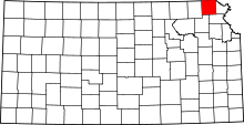 | |
| CDPs | ||
| Unincorporated communities | ||
| Indian reservations | ||
| Townships | ||
| Footnotes | ‡This populated place also has portions in an adjacent county or counties | |