Hamilton, New South Wales
| Hamilton Newcastle, New South Wales | |||||||||||||
|---|---|---|---|---|---|---|---|---|---|---|---|---|---|
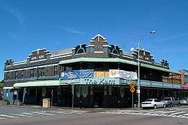 The Kent Hotel, est. 1924, is a landmark on Beaumont Street | |||||||||||||
| Population | 4,071 (2011 census)[1] | ||||||||||||
| • Density | 2,910/km2 (7,530/sq mi) | ||||||||||||
| Established | 11 December 1871 | ||||||||||||
| Postcode(s) | 2303 | ||||||||||||
| Area | 1.4 km2 (0.5 sq mi) | ||||||||||||
| Location | 4 km (2 mi) W of Newcastle | ||||||||||||
| LGA(s) | City of Newcastle | ||||||||||||
| Parish | Newcastle | ||||||||||||
| State electorate(s) | Newcastle | ||||||||||||
| Federal Division(s) | Newcastle | ||||||||||||
| |||||||||||||
Hamilton is a suburb of Newcastle, New South Wales, Australia, located 4 kilometres (2.5 mi) from Newcastle's central business district. The main commercial centre is located around Beaumont Street and boasts a vibrant multicultural atmosphere providing an array of restaurants, retail, fashion and commercial outlets along with day-to-day services such as pharmacies, banks, florists, hairdressers, fruit shops and delicatessens.[2] A local history blog 'Hidden Hamilton' captures the people, places and experiences that make up the collective story of Hamilton since its earliest beginnings (see http://hiddenhamilton.blogspot.com.au).
History
Hamilton became a municipality on 11 December 1871 and was named in honour of Edward Terrick Hamilton, who was then Governor of the board of directors of the Australian Agricultural Company (AA Co), from August 1857 to September 1898. The AA Co. were instrumental in the growth of the area, operating the mines and owning most of the land.[2]
The discovery of coal near St Peter's Church in the area known as Cameron's Hill, was the beginnings for the township of Hamilton (originally known as Pittown, Borehole or Happy Flat). A borehole was sunk and a shaft was completed in 1849 and was known as the D Pit, or borehole. Pittown grew up somewhere in the vicinity of today’s Beaumont street to service the needs of the miners and their families.[2]
By 1928 there were over 400 retail outlets in Hamilton, having increased from 80 in 1909.[2]
In 1947, Lettesi (a settler group made up of nearly 150 families from the village of Lettopalena in the Abruzzo Region of Italy), initially settled in Islington but they soon expanded into the nearby suburbs of Hamilton and Mayfield. This was primarily due to Islington's proximity to the BHP steel works. Before long Hamilton (especially Beaumont Street) was to become a strong community and commercial centre for Newcastle’s Italians.[3] By the late fifties, the local Italian community began patronising the Australian owned Exchange Hotel, located on the corner of Beaumont and Denison Streets. It continues to be a regular meeting place for Italian men of Hamilton.[3] The story of the Lettesi community in Hamilton can be read in the 'Hidden Hamilton' blog at http://hiddenhamilton.blogspot.com.au/2015/12/a-community-finds-its-place-lettesi.html.
Transport
Rail

Hamilton's train station was constructed on the Islington Junction to Newcastle railway line. The station is 164 km (102 mi) from the Way & Works Branch[4] and is 5.8 m (19 ft) above sea level.[5] With the opening of the station in 1872, the importance of Hamilton as a suburb grew.
The station is served by NSW TrainLink's Hunter line to Maitland and beyond, and the Central Coast & Newcastle Line, which runs to Sydney.
Bus
Hamilton is the home to Newcastle's major State Transit Authority bus depot.
Gallery
-
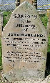
Grave Stone of John Marland, who died whilst working in the Borehole. This grave stone is located behind the Christchurch Cathedral, Newcastle, New South Wales
-

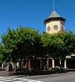
Hamilton train station, located at the Northern end of Beaumont Street.
-
James Street Square, separates Beaumont Street from James Street.
-

Mosaics on the side of a Hamilton pharmacy.
-
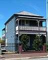
A Victorian townhouse on Beaumont street.
References
- ↑ Australian Bureau of Statistics (31 October 2012). "Hamilton (State Suburb)". 2011 Census QuickStats. Retrieved 24 October 2013.
- 1 2 3 4 Newcastle City Council, Discover our Suburbs
- 1 2 A History of Italian Settlement in New South Wales
- ↑ The Way and Works Branch performed the civil engineering tasks for the New South Wales rail system.
- ↑ Station Names. Date of opening, closing and/or change of name. Public Transport Commission of New South Wales. Administrative Branch (Archives Section) (3rd ed.). February 1979 [1965]. p. 15.
External links
Coordinates: 32°54′54″S 151°45′04″E / 32.915°S 151.751°E