Halton Hills
| Halton Hills | |||
|---|---|---|---|
| Town (lower-tier) | |||
| Town of Halton Hills | |||
|
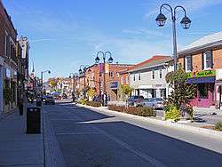
Main Street, Georgetown | |||
| |||
| Motto: Hereditas Integritas Veritas (Latin: Heritage, integrity, truth) | |||
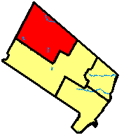 Location of Halton Hills in Halton Region | |||
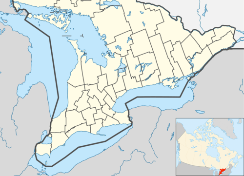 Halton Hills Location of Halton Hills in Ontario | |||
| Coordinates: 43°38′N 79°57′W / 43.63°N 79.95°WCoordinates: 43°38′N 79°57′W / 43.63°N 79.95°W | |||
| Country |
| ||
| Province |
| ||
| Region | Halton | ||
| Incorporated | 1974 | ||
| Government | |||
| • Mayor | Rick Bonnette | ||
| • Federal riding | Wellington—Halton Hills | ||
| • Prov. riding | Wellington—Halton Hills | ||
| Area | |||
| • Land | 276.26 km2 (106.66 sq mi) | ||
| • Urban | 39.52 km2 (15.26 sq mi) | ||
| • Rural | 236.74 km2 (91.41 sq mi) | ||
| Highest elevation[1] | 411 m (1,348 ft) | ||
| Lowest elevation[2] | 197 m (646 ft) | ||
| Population (2011) | |||
| • Town (lower-tier) | 59,008 | ||
| • Density | 213.60/km2 (553.2/sq mi) | ||
| • Urban | 49,854 | ||
| • Urban density | 1,300/km2 (3,300/sq mi) | ||
| • Rural | 9,154 | ||
| • Rural density | 39/km2 (100/sq mi) | ||
| Time zone | EST (UTC-5) | ||
| • Summer (DST) | EDT (UTC-4) | ||
| Area code(s) | 905, 289 and 365 | ||
| NTS Map | 030M12 | ||
| GNBC Code | FBLIE | ||
| Website | www.haltonhills.ca | ||

Halton Hills is a town in the Regional Municipality of Halton, located in the northwestern end of the Greater Toronto Area, Ontario, Canada.
The primary population centres are Georgetown and Acton. Additionally, there are a number of hamlets and rural clusters within the town, including Ashgrove, Ballinafad (straddling the boundary with Erin), Bannockburn, Crewsons Corners (straddling the boundary with Erin, Guelph-Eramosa and Milton), Glen Williams, Henderson's Corners, Hornby, Limehouse, Mansewood, Norval, Scotch Block, Silver Creek, Speyside, Stewarttown, Terra Cotta (straddling the boundary with Caledon), and Wildwood.
There are also natural features within these bounds, including the Niagara Escarpment, and the Bruce Trail. Many of these local features are protected by the Conservation Halton, Credit Valley Conservation & Grand River Conservation Authority.
Geography
| Black Creek | |
| River | |
| Basin | 79.28 km2 (31 sq mi) |
|---|---|
| Discharge | for 43°37′45″N 80°0′37″W / 43.62917°N 80.01028°W |
| - average | 0.231 m3/s (8 cu ft/s) |
| - max | 0.353 m3/s (12 cu ft/s) |
| - min | 0.142 m3/s (5 cu ft/s) |
| Credit River, West Branch | |
| River | |
| Basin | 127.00 km2 (49 sq mi) |
|---|---|
| Discharge | for 43°38′47″N 79°51′58″W / 43.64639°N 79.86611°W |
| - average | 1.33 m3/s (47 cu ft/s) |
| - max | 2.06 m3/s (73 cu ft/s) |
| - min | 0.683 m3/s (24 cu ft/s) |
The town is bisected by the Niagara Escarpment from southwest to northeast, and a significant portion of the rural area is located within the provincial Greenbelt. Above the Escarpment, a large proportion of the rural area is classified as environmentally sensitive wetlands, and there are several sites that are licensed for aggregate extraction, for which expansion requires detailed environmental assessment.[3] Below the Escarpment, the rural area is mainly agricultural, with the exception of an industrial area currently being development between Highway 401 and Steeles Avenue.
The town also forms part of three watersheds:
- to the west of Acton, a small area flows toward the Grand River
- the northern half flows into the Credit River, including the Black Creek[4] and Silver Creek[5] tributaries
- the southern half flows into the Sixteen Mile Creek[6]
The Water Survey of Canada operates two hydrometric monitoring stations in the town, on the Black Creek below Acton,[7] and at Norval on the Credit River.[8]
Vegetation
Halton Hills is located in the transition zone between the Huron-Ontario Forest Section of the Great Lakes-St. Lawrence forest zone to the north and the Niagara Section of the Carolinian forest zone to the south. Both forest zones are part of the Mixedwood Plains Ecozone. The natural vegetation in the Huron-Ontario Section is dominated by mixed wood forests. It is a transitional type between the southern deciduous forests and the northern coniferous forests. The forest communities of the Niagara Section are dominated by broad-leaved trees. Overall, Halton Hills consists predominantly of agricultural lands with scattered woodlands and wetlands. The woodlands are mainly deciduous forest and the wetlands are either cedar swamp or cattail marsh.[9]
Endangered and threatened species
American ginseng exists in the town, and is protected under the Endangered Species Act, 2007. Butternut trees are also threatened by the butternut canker. The hooded warbler and the Jefferson salamander are also designated as threatened species.
Brook trout had been eliminated from the Black Creek watershed for many years, following an environmental disaster south of Acton in March 1946. The trout have since returned, and anglers report that fishing is good.[10]
Geology
The physiography[11] and distribution of surface material[12] in the Town of Halton Hills are the result of glacial activity which took place in the Late Wisconsinan Substage of the Pleistocene Epoch. This period of time, which lasted from approximately 23,000 to 10,000 years ago, was marked by the repeated advance and melting back of massive, continental ice sheets.
The Niagara Escarpment dominates the physiography of the town and greatly influenced the pattern of glaciation in the region. The Escarpment, formed by erosion over millions of years, is a high relief bedrock scarp which trends to the north through the central part of the town. To the west, on the upper surface of the Escarpment, hummocky morainic ridges deposited by glacial ice form part of the Horseshoe Moraines physiographic region. To the southeast below the Escarpment, is a smooth glacial till plain partially bevelled by lacustrine action, which forms part of the South Slope and Peel Plain physiographic regions.
The Town of Halton Hills is underlain by Ordovician shales of the Queenston Formation east of the Niagara Escarpment, and by Silurian dolostones of the Amabel Formation west of the Escarpment. The escarpment face exposes a complex succession of shales, sandstones, limestones and dolostones of the Clinton and Cataract Groups. Red shales of the Queenston Formation underlie the eastern half of the town and are generally covered by more than 15 m of glacial sediments, predominantly the Halton Till. There are several areas of thin drift cover south of Georgetown.
The quarrying of limestone has been undertaken since the 19th century, and the lime industry was once quite prevalent. In 1886, the Toronto Lime Company had operations in Limehouse and Acton, employing a total of four draw kilns and eleven set kilns, producing common lime and water lime.[13] At Limehouse, rock from the Clinton formation yielded green and brown shales and blue marl, which were used in the manufacture of mineral paints.[13]
Small oil and gas deposits have been discovered northwest and south of Acton, and around Hornby. While exploration had occurred as early as 1908,[14] with oil being discovered in 1912,[15] significant strikes did not occur until 1954.[16]
The town is located in an area that is considered to be of low seismic potential, and the largest recent earthquake to take place within its limits was of magnitude 3 on 29 June 1955.[17] There is a POLARIS seismic monitoring station located just west of Acton.[18][19]
Climate
Halton Hills has a humid continental climate (Köppen climate classification Dfb).
The Town has two distinct climate zones:[20]
- Zone 5a - north of the Niagara Escarpment
- Zone 5b - south of the Escarpment
Environment Canada operates one climate monitoring station at Georgetown.
| Climate data for Georgetown WWTP (Halton Hills), 1981−2010 | |||||||||||||
|---|---|---|---|---|---|---|---|---|---|---|---|---|---|
| Month | Jan | Feb | Mar | Apr | May | Jun | Jul | Aug | Sep | Oct | Nov | Dec | Year |
| Record high °C (°F) | 17.0 (62.6) |
15.5 (59.9) |
25.0 (77) |
31.5 (88.7) |
34.5 (94.1) |
36.0 (96.8) |
37.0 (98.6) |
36.5 (97.7) |
35.5 (95.9) |
29.5 (85.1) |
22.0 (71.6) |
20.5 (68.9) |
37.0 (98.6) |
| Average high °C (°F) | −1.7 (28.9) |
−0.2 (31.6) |
4.6 (40.3) |
12.1 (53.8) |
19.1 (66.4) |
24.4 (75.9) |
26.9 (80.4) |
25.8 (78.4) |
21.4 (70.5) |
14.3 (57.7) |
7.3 (45.1) |
1.1 (34) |
12.9 (55.2) |
| Daily mean °C (°F) | −6.3 (20.7) |
−5.2 (22.6) |
−0.9 (30.4) |
6.0 (42.8) |
12.3 (54.1) |
17.4 (63.3) |
20.0 (68) |
19.0 (66.2) |
14.8 (58.6) |
8.4 (47.1) |
2.8 (37) |
−2.9 (26.8) |
7.1 (44.8) |
| Average low °C (°F) | −10.9 (12.4) |
−10.2 (13.6) |
−6.4 (20.5) |
−0.2 (31.6) |
5.3 (41.5) |
10.4 (50.7) |
13.0 (55.4) |
12.1 (53.8) |
8.1 (46.6) |
2.4 (36.3) |
−1.7 (28.9) |
−6.9 (19.6) |
1.3 (34.3) |
| Record low °C (°F) | −33.0 (−27.4) |
−31.5 (−24.7) |
−28.0 (−18.4) |
−13.0 (8.6) |
−5.0 (23) |
−0.5 (31.1) |
3.0 (37.4) |
0.0 (32) |
−4.0 (24.8) |
−8.5 (16.7) |
−15.5 (4.1) |
−29.5 (−21.1) |
−33.0 (−27.4) |
| Average precipitation mm (inches) | 67.8 (2.669) |
60.0 (2.362) |
57.2 (2.252) |
76.5 (3.012) |
79.3 (3.122) |
74.8 (2.945) |
73.5 (2.894) |
79.3 (3.122) |
86.2 (3.394) |
68.3 (2.689) |
88.5 (3.484) |
65.9 (2.594) |
877.4 (34.543) |
| Average rainfall mm (inches) | 29.7 (1.169) |
28.4 (1.118) |
35.2 (1.386) |
71.3 (2.807) |
79.0 (3.11) |
74.8 (2.945) |
73.5 (2.894) |
79.3 (3.122) |
86.2 (3.394) |
67.8 (2.669) |
79.9 (3.146) |
36.4 (1.433) |
741.5 (29.193) |
| Average snowfall cm (inches) | 38.1 (15) |
31.7 (12.48) |
22.1 (8.7) |
5.2 (2.05) |
0.3 (0.12) |
0.0 (0) |
0.0 (0) |
0.0 (0) |
0.0 (0) |
0.5 (0.2) |
8.6 (3.39) |
29.5 (11.61) |
135.9 (53.5) |
| Average precipitation days (≥ 0.2 mm) | 12.6 | 9.4 | 10.6 | 12.4 | 11.9 | 11.2 | 10.6 | 10.6 | 11.7 | 12.3 | 13.3 | 12.3 | 138.9 |
| Average rainy days (≥ 0.2 mm) | 4.1 | 4.1 | 6.4 | 11.6 | 11.8 | 11.2 | 10.6 | 10.6 | 11.7 | 12.2 | 11.4 | 6.5 | 112.1 |
| Average snowy days (≥ 0.2 cm) | 9.4 | 6.2 | 4.8 | 1.4 | 0.04 | 0.0 | 0.0 | 0.0 | 0.0 | 0.27 | 2.5 | 6.9 | 31.5 |
| Source: Environment Canada[21] | |||||||||||||
History
Halton Hills was established in 1974 through the amalgamation of the former Towns of Georgetown and Acton, together with much of the former Township of Esquesing, and a small portion of the Town of Oakville lying north of Ontario Highway 401.
On August 1, 2013, Toronto Premium Outlets, the first Premium Outlets Centre in Canada, opened for business.[22]
Demographics
| Halton Hills | ||
|---|---|---|
| Year | Pop. | ±% |
| 1981 | 35,190 | — |
| 1991 | 36,816 | +4.6% |
| 1996 | 42,390 | +15.1% |
| 2001 | 48,184 | +13.7% |
| 2006 | 55,289 | +14.7% |
| 2011 | 59,008 | +6.7% |
According to the Canada 2011 Census,[23] the population of Halton Hills is 59,008, a 6.7% increase from 2006. The population density is 213.6 people per square km. The median age is 39.9 years old, almost on par with the national median at 40.6 years old. There are 20,548 private dwellings with an occupancy rate of 98.6%. According to the 2011 National Household Survey, the median value of a dwelling in Halton Hills is $400,491 which is significantly higher than the national average at $280,552. The median household income (after-taxes) in Halton Hills is $80,266, a lot higher than the national average at $54,089.
Halton Hills is mostly made up of European descents. The racial make up of Halton Hills is:
- 93.5% White
- 1.6% South Asian; 0.9% Indian, 0.7% Pakistani, 0.1% Sri Lankan
- 1.4% Aboriginal; 0.8% First Nations, 0.4% Metis
- 1.0% Black
- 0.9% East Asian; 0.6% Chinese, 0.1% Korean, 0.2% Japanese
- 0.6% Southeast Asian; 0.4% Filipino
- 0.6% Latin American
- 0.1% West Asian
- 0.0% Arab
- 0.3% Multiracial; 0.7% including Metis
- 0.2% Other
Religiously, most people in Halton Hills identify or affiliate either with Christianity (72.1%), or with no religion (26.3%). The remaining 1.6% affiliate with another religion.
| Canada census – Halton Hills, ON community profile | |||
|---|---|---|---|
| 2011 | 2006 | 2001 | |
| Population: | 59,008 (6.7% from 2006) | 55,289 (14.7% from 2001) | 48,184 (13.7% from 1996) |
| Land area: | 276.25 km2 (106.66 sq mi) | 276.26 km2 (106.66 sq mi) | 276.35 km2 (106.70 sq mi) |
| Population density: | 213.6/km2 (553/sq mi) | 200.1/km2 (518/sq mi) | 174.4/km2 (452/sq mi) |
| Median age: | 39.9 (M: 39.3, F: 40.4) | 37.9 (M: 37.5, F: 38.2) | 36.3 (M: 36.0, F: 36.6) |
| Total private dwellings: | 20,548 | 19,265 | 16,716 |
| Median household income: | $94,190 | $85,520 | $74,921 |
| References: 2011[24] 2006[25] 2001[26] | |||
| Group | 2011 Census | 2006 Census | 2001 Census | 1996 Census | ||||
|---|---|---|---|---|---|---|---|---|
| Population | % of total | Population | % of Total | Population | % of Total | Population | % of Total | |
| Aboriginal | 1,645 | 2.8 | 480 | 0.9 | 205 | 0.4 | 140 | 0.3 |
| Visible Minority | 2,980 | 5.2 | 2,235 | 4.1 | 1,625 | 3.4 | 1,195 | 2.8 |
| All other | 53,325 | 92.0 | 52,305 | 95.0 | 46,155 | 96.2 | 40,910 | 96.9 |
| Total | 57,950 | 100.0 | 55,020 | 100.0 | 47,985 | 100.0 | 42,245 | 100.0 |
| Group | 2011 Census | 2006 Census | 2001 Census | 1996 Census | ||||
|---|---|---|---|---|---|---|---|---|
| Population | % of total | Population | % of Total | Population | % of Total | Population | % of Total | |
| English | 50,525 | 86.0 | 47,765 | 86.8 | 42,305 | 88.2 | 37,425 | 88.6 |
| French | 1,270 | 2.2 | 1,025 | 1.9 | 1,035 | 2.2 | 750 | 1.8 |
| English and French | 170 | 0.3 | 75 | 0.1 | 45 | - | 90 | 0.2 |
| All other | 6,305 | 10.7 | 6,155 | 11.2 | 4,590 | 9.6 | 3,980 | 9.4 |
| Total | 58,725 | 100.0 | 55,020 | 100.0 | 47,985 | 100.0 | 42,245 | 100.0 |
(Other languages, 2011: Polish 1.4%, Portuguese 1.3%, Italian 1.1%, German 1.0%)
| Group | 2011 Census | 2006 Census | 2001 Census | 1996 Census | ||||
|---|---|---|---|---|---|---|---|---|
| Population | % of total | Population | % of Total | Population | % of Total | Population | % of Total | |
| At the same address | 37,510 | 68.6 | 30,270 | 58.9 | 25,135 | 56.4 | 22,370 | 57.4 |
| In the same municipality | 7,460 | 13.6 | 8,480 | 16.5 | 17,540 | 39.3 | 7,175 | 18.4 |
| In the same province | 8,625 | 15.8 | 11,180 | 21.7 | 8,285 | 21.2 | ||
| From another province | 520 | 1.0 | 765 | 1.5 | 1,920 | 4.3 | 735 | 1.9 |
| From another country | 525 | 1.0 | 720 | 1.4 | 430 | 1.1 | ||
| Total aged 5 or over | 54,640 | 100.0 | 51,420 | 100.0 | 44,595 | 100.0 | 39,000 | 100.0 |
Local government
The town is divided into four wards, each of which elects two local councillors. Two regional councillors are also elected - one from Wards 1 and 2 (i.e., the area that was in the former Town of Acton and the former Township of Esquesing), and one from Wards 3 and 4 (i.e., the area in the former Town of Georgetown). The mayor is elected at large. The mayor and the regional councilors represent the town at the council meetings of the Regional Municipality of Halton.
The current membership of the town council is as follows:[27]
| Position | Ward 1 | Ward 2 | Ward 3 | Ward 4 |
|---|---|---|---|---|
| Mayor | Rick Bonnette | |||
| Regional Councillor | Clark Somerville | Jane Fogal | ||
| Local Councillor | Jon Hurst | Ted Brown | Moya Johnson | Bob Inglis |
| Mike Albano | Bryan Lewis | David Kentner | Ann Lawlor | |
The libraries in the Town are managed by the Halton Hills Public Library Board.
Symbols
In 1975, the Lord Lyon King of Arms awarded arms to the town, followed by the grant of a badge in 1984. Both were subsequently registered with the Canadian Heraldic Authority in 2005. They are specifically described as follows:[28]
- Arms: Per pale, dexter Or two bendlets wavy Sable, sinister Azure two escarpes wavy Argent, a chief per fess dancetty Azure and Argent, overall a white pine tree (Pinus strobus) proper;
- Motto: Hereditas Integritas Veritas (Latin: Heritage, integrity, truth)
- Badge: On an oval Azure a white pine tree Argent within a wreath of five oak leaves alternating with five papyrus leaves Or.
Transportation
The town has four main roads:
East-west
-
 Highway 7 connecting Acton and Georgetown
 - Regional Road 8 (Steeles Avenue) between Milton and Brampton
North-south
- Regional Road 25 between Acton and Milton
- Regional Road 3 (Trafalgar Road) between Ballinafad and Oakville
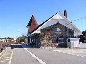
Bus service is provided by GO Transit along Highway 7 on its Georgetown line corridor. Via Rail and GO Train service are provided at Georgetown GO Station.
The Grand Trunk Railway brought train service to the area in 1856, with stations at Acton and Georgetown. Passenger service to Acton ceased in the 1990s, but GO Train service is planned to be revived there in 2013.[29]
Rail freight service is also provided by Canadian National on its Halton Subdivision from Georgetown southwest through Milton to Burlington.[30] CN's Guelph Subdivision between Georgetown and London is currently managed by Goderich–Exeter Railway.
From 1917 to 1931, Norval, Georgetown and Acton were also served by the Toronto Suburban Railway.[31]
Schools
| Type | Halton District School Board | Halton Catholic District School Board | Independent |
|---|---|---|---|
| Secondary school | |||
| Primary school |
|
|
Media
Halton Hills is covered by the following local newspapers and online media:
- Georgetown Independent
- Acton Free Press
- The Acton New Tanner
- The Halton Compass
- Halton Herald
- In Georgetown Community Website
In addition, the transmitter for clear channel radio station CFZM is located in Hornby. This facility had long been used by CBC Radio One flagship CBL.
See also
References
- ↑ 43°39′25.49″N 80°3′17.98″W / 43.6570806°N 80.0549944°W, as per Google Earth
- ↑ along Highway 401, as per Google Earth
- ↑ "Level I and II Natural Environment Technical Report - Acton Quarry Extension, Town of Halton Hills, Ontario". 2008-12-22. Retrieved 2012-02-20.
- ↑ "Background Report - Black Creek Subwatershed Study" (PDF). Credit Valley Conservation. February 2009. Retrieved 2012-02-20.
- ↑ "Silver Creek Subwatershed Study Background Report" (PDF). Credit Valley Conservation. September 2001. Retrieved 2012-02-20.
- ↑ "Sixteen Mile Creek, Grindstone Creek and Supplemental Monitoring" (PDF). Conservation Halton. October 2010. Retrieved 2012-02-20.
- ↑ "BLACK CREEK BELOW ACTON (02HB024)". Retrieved 2012-02-20.
- ↑ "CREDIT RIVER WEST BRANCH AT NORVAL (02HB008)". Retrieved 2012-02-20.
- ↑ "Appendix E - Halton Hills Local Refinement Area Natural Environment Setting" (PDF). Hydro One. Retrieved 2012-02-20.
- ↑ Hartley Coles (2009-05-14). "Black Creek has much influence" (PDF). The New Tanner. Retrieved 2012-02-20.
- ↑ "Aggregate Resources Inventory of the Town of Halton Hills" (PDF). Ontario Geological Survey. 1983. Retrieved 2012-02-20.
- ↑ J.E. Gillespie; R.E. Wicklund; M.H. Miller. "Soils of Halton County - Report No. 43 of the Ontario Soil Survey" (PDF). Soil Research Institute, Canada Department of Agriculture, and Ontario Agricultural College. Retrieved 2012-02-23.
- 1 2 Annual Report of the Bureau of Industries for the Province of Ontario. Toronto: Warwick & Sons. 1886. p. 385.
- ↑ "News of local import: Halton Oil and Gas". Acton Free Press. September 17, 1908. p. 3.
- ↑ "Oil has been struck at Milton". Acton Free Press. March 7, 1912. p. 2.
- ↑ Gord Murray (February 20, 1980). "Gas riches may await the gambler". Acton Free Press. p. 1.
- ↑ "Could the next big earthquake happen here?". 2011-03-21. Retrieved 2012-02-21.
- ↑ POLARIS monitoring station ACTO
- ↑ located at 43°36′31″N 80°03′45″W / 43.6087°N 80.0624°W
- ↑ Plant Hardiness Zones of Canada
- ↑ "Georgetown WWTP". Canadian Climate Normals 1981–2010. Environment Canada. Retrieved 2015-02-17.
- ↑ "Opening day for Toronto Premium Outlets | Toronto & GTA | News". Toronto Sun. Retrieved 2013-08-27.
- ↑ 2011 NHS/Census Profile of Halton Hills: http://www12.statcan.gc.ca/nhs-enm/2011/dp-pd/prof/details/page.cfm?Lang=E&Geo1=CSD&Code1=3524015&Data=Count&SearchText=halton%20hills&SearchType=Begins&SearchPR=01&A1=All&B1=All&Custom=&TABID=1
- ↑ "2011 Community Profiles". Canada 2011 Census. Statistics Canada. July 5, 2013. Retrieved 2012-02-08.
- ↑ "2006 Community Profiles". Canada 2006 Census. Statistics Canada. March 30, 2011. Retrieved 2012-02-01.
- ↑ "2001 Community Profiles". Canada 2001 Census. Statistics Canada. February 17, 2012. Retrieved 2012-02-01.
- ↑ "Halton Hills 2014 Municipal Election Results". Town of Halton Hills.
- ↑ Canadian Heraldic Authority - Halton Hills, Ontario - Registration of Arms and Badge, March 15, 2005, Vol. IV, p. 454
- ↑ "GO trains coming to Kitchener Dec. 19". Waterloo Region Record. Retrieved 2012-02-21.
- ↑ "CN Halton Subdivision". Retrieved 2012-02-26.
- ↑ "Toronto Suburban Railway - Guelph Radial Line". Retrieved 2012-02-26.
External links
-
 Media related to Halton Hills at Wikimedia Commons
 |
Erin | Caledon | | |
| Guelph/Eramosa | |
Brampton | ||
| ||||
| | ||||
| Milton | Mississauga |
Largest city: Toronto | ||
| Regions |  | |
| Cities | ||
| Towns | ||
| Townships and municipalities | ||