Hall bei Admont
| Hall | |
|---|---|
 | |
 Hall Location within Austria | |
| Coordinates: 47°35′56″N 14°27′34″E / 47.59889°N 14.45944°ECoordinates: 47°35′56″N 14°27′34″E / 47.59889°N 14.45944°E | |
| Country | Austria |
| State | Styria |
| District | Liezen |
| Government | |
| • Mayor | Hermann Watzl (SPÖ) |
| Area | |
| • Total | 50.72 km2 (19.58 sq mi) |
| Elevation | 634 m (2,080 ft) |
| Population (1 January 2016)[1] | |
| • Total | 1,744 |
| • Density | 34/km2 (89/sq mi) |
| Time zone | CET (UTC+1) |
| • Summer (DST) | CEST (UTC+2) |
| Postal code | 8911 |
| Area code | 03613 |
| Vehicle registration | LI |
| Website | www.gemeinde-hall.at/ |
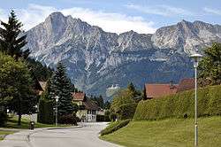
Hall bei Admont is a former municipality in Liezen district in the Austrian Styria at the foot of the Haller Mauern on the Enns River. Since the 2015 Styria municipal structural reform, it is part of the municipality Admont.[2]
It has the oldest salt mine in Styria, as mentioned in a 931 document, which operated until 1543.
Geography
Hall lies on the left bank of the Enns just across from Admont.
References
This article is issued from Wikipedia - version of the 11/22/2016. The text is available under the Creative Commons Attribution/Share Alike but additional terms may apply for the media files.