Halba
| Halba حلبا | |
|---|---|
| City | |
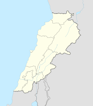 Halba Location within Lebanon | |
| Coordinates: 34°33′2″N 36°4′41″E / 34.55056°N 36.07806°ECoordinates: 34°33′2″N 36°4′41″E / 34.55056°N 36.07806°E | |
| Country |
|
| Governorate | North Governorate |
| District | Akkar District |
| Elevation | 167 m (548 ft) |
| Time zone | EET (UTC+2) |
| • Summer (DST) | EEST (UTC+3) |
| Dialing code | +961 |
Halba (Arabic: حلبا) is the capital of the Akkar District in the North Governorate of Lebanon, close to the border with Syria. It is located at around 34°33′2″N 36°4′41″E / 34.55056°N 36.07806°E.
The population in Halba is divided between Sunni Muslims, Greek Orthodox Christians and other confessions.[1]
Halba is home to Sada Akkar Newspaper, the only privately owned news agency in Akkar District. Halba is also home to a Lebanese Red Cross First Aid Center.
References
- ↑ "Municipal and ikhtiyariah elections in Northern Lebanon" (PDF). The Monthly. March 2010. p. 21. Archived from the original on 3 June 2016. Retrieved 4 November 2016.
External links
- Halba, Localiban
- Halba news section on Sada Akkar newspaper
Capital: Halba | ||
| Towns and villages | 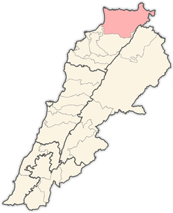 | |
This article is issued from Wikipedia - version of the 11/4/2016. The text is available under the Creative Commons Attribution/Share Alike but additional terms may apply for the media files.