Hadzhi Dimitar Peak
Hadzhi Dimitar Peak (Bulgarian: връх Хаджи Димитър, ‘Vrah Hadzhi Dimitar’ \'vr&h ha-'dzhi di-'mi-tar\) is the mostly ice-covered peak of elevation 2000 m in the west foothills of Avery Plateau on Loubet Coast in Graham Land, Antarctica. It has steep and partly ice-free west and east slopes, and surmounts Hopkins Glacier to the west and north, and a tributary to that glacier to the southwest.
The peak is named after Hadzhi Dimitar (Dimitar Asenov, 1840–1868), a leader of the Bulgarian liberation movement, in connection with the settlement of Hadzhi Dimitar in Northeastern Bulgaria.
Location
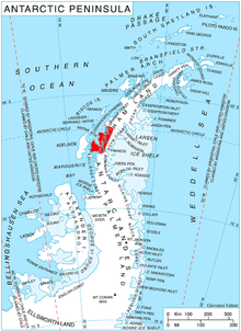
Hadzhi Dimitar Peak is located at 66°36′06″S 65°25′56″W / 66.60167°S 65.43222°WCoordinates: 66°36′06″S 65°25′56″W / 66.60167°S 65.43222°W, which is 14.95 km east of Gostilya Point on Darbel Bay, 5.67 km south of Mount Bain, 7.7 km west of Stefan Karadzha Peak and 7.6 km northeast of Voit Peak. British mapping in 1976.
Maps
- Antarctic Digital Database (ADD). Scale 1:250000 topographic map of Antarctica. Scientific Committee on Antarctic Research (SCAR). Since 1993, regularly upgraded and updated.
- British Antarctic Territory. Scale 1:200000 topographic map. DOS 610 Series, Sheet W 66 64. Directorate of Overseas Surveys, Tolworth, UK, 1976.
References
- Bulgarian Antarctic Gazetteer. Antarctic Place-names Commission. (details in Bulgarian, basic data in English)
- Hadzhi Dimitar Peak. SCAR Composite Antarctic Gazetteer.
This article includes information from the Antarctic Place-names Commission of Bulgaria which is used with permission.