Haast River
| Haast River | |
|---|---|
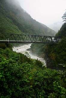 Haast River in the mountains | |
| Country | New Zealand |
| Basin | |
| Main source | Southern Alps |
| River mouth | Tasman Sea |
| Physical characteristics | |
| Length | 100 km (62 mi) |
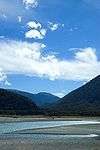
The Haast River has its terminus on the West Coast of the South Island of New Zealand.
The Haast River drains the western watershed of the Haast Pass. It is 100 kilometres in length, and enters the Tasman Sea near Haast township. The river's main tributary is the Landsborough River.
The grassy flats on the lower reaches are grazed by cattle by the local farmers. Tourism operators offer jetboat tours on the river.
The river often has glacial silt in suspension in the water from glaciers in the Southern Alps. The majority of the surrounding land is publicly owned and administered by the Department of Conservation. It is set within the Te Wahipounamu World Heritage site.

State Highway 6 follows virtually the complete length of the river, with a bridge near the coast, just after the turnoff to the Haast township. At 737 metres (2,418 ft) it is the longest one-lane road bridge in New Zealand, and the 7th longest New Zealand bridge overall.[1]
The river is named after Julius von Haast.
References
- ↑ "Transit New Zealand Frequently Asked Questions". Retrieved 2008-09-23.
External links
-
 Media related to Haast River at Wikimedia Commons
Coordinates: 43°50′S 169°02′E / 43.833°S 169.033°E