Pak Nai
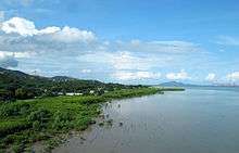

Pak Nai (Chinese: 白泥) is a wetland area, partly mud-bank, surrounded by mountain ranges, in the Yuen Long District while facing the Shenzhen Bay. As the landscape works in great diversity. Pak Nai makes up the coastline as Sheung Pak Nai (上白泥) and Ha Pak Nai (下白泥) geographically.
It is known for sunset viewing and as one of the relic site dated back to couple thousands years ago. Pak Nai is famous for its ecosystem which comes with rich biodiversity, with rare species found offshore. And, intense public concerns were paid in recent years as a controversial development proposal sparked out, which eventually dropped out under huge objections.
Attraction


Ha Pak Nai (“Ha” means “lower”) is best-known as being one of the best places for watching sunset in Hong Kong,[1] making it a beloved place of so many photographers, tourists and dating couples.[2] The best spots for the view of sunset are the shore along Ha Pak Nai and the junction of Deep Bay Road and Nim Wan Road.[3] It is noticeable that Nim Wan Road is the nearest road to the sea in Hong Kong and also a popular 5 km cycling route for locals.[4]
Ha Pak Nai's 6 km long shoreline is where mangroves, wetland and mud-bank are found. Therefore, rich biodiversity allows Pak Nai to become Site of Special Scientific Interest.[5] Some species of crabs such as Perisesarma bidens and Ilyoplax tansuiensis are highlights of Ha Pak Nai. In addition, Ha Pak Nai used to be an oyster bed, thus, there is still remains of oyster shells all over the flat.[6]
Apart from the natural scenic spots, couples of relics can be found in Pak Nai. The most remarkable one is the fortified structure at No.55 Ha Pak Nai, which is a declared monument due to its connection with revolutionary movement under the leadership of Dr. Sun Yat-sen.
Scenery
According to the photography tutorial by Canon Hong Kong Company Limited, it is suggested that scenery, such as reflections of the setting sun and silhouettes, taken during the sunset glow is more artistic. Sunset glow, which is also named as “the Magic Hour”, creates a rich visual rendition and subtle gradation of warm and cool colors.
Different local features - mud flat, sails, oyster farms, container terminals, and so forth - can also be included to enhance the composition.[7]
Ecology
In the mangrove in Ha Pak Nai live various species, which is highly conserved by environmentalists.
Crabs, for example, Perisesarma bidens, Ilyoplax tansuiensis, Uca arcuata, and Sesarma sinensis are commonly found in the offshore mud flat.[4]
Among all crabs found in the Ha Pak Nai area, Horseshoe crab is one of the most highly conserved species. Horseshoe crabs originate from 450 millions years ago; therefore, they are also called as “living fossils”. Because of the copper in their blood, which can be extracted to be applied in detecting bacteria, Horseshoe crabs are highly valued in medical aspect.[8]
Archaeology and History

There are two major relics and one historical site found around the Pak Nai area, which are the sand dunes of the Chen’s homeland, Wu’s homeland and a fortified structure. The Antiquities and Monuments Office found the Chen’s relic in May, 1997, featuring a one meter high sand dune containing two culture levels.[9][10] The excavation team found 4 postholes, 9 stone stoves, 3 kilns and 1 grave which it was the first time for Hong Kong excavating sun and moon utensils.[9] The Wu’s relic was found in September, 1997 by the same excavation team. They found culture levels in three time periods, having rammed earth foundations, stone artifacts and more.[11]Xingzhonghui (Revive China Society) members, who were KMT, stationed at Lower Pak Nai for preparation of overturning the ruling of Qing authority and conducted bomb tests.[12] (Luo 1971:37) A fortified structure at No. 55 Ha Pak Nai (Lower Pak Nai area) was built by a core member of Xingzhonghui named Tang Yam-nam around 1910. It was the only solid evidence correlating the 1911 revolution and its movement leader Sun Yat-sen and his comrades. The structure served for the surveillance across the Deep Bay coast under the Qing authority.[13]
Development
Former Heung Yee Kuk chairman Lau Wong-fat applied for the development of Ha Pak Nai in 2007, but vigorous opposition made the proposal withdrew.[14] In 2010, Lau hope to pass the assessment of the Town Planning Board by sharply reducing the scale of development and gave up building a golf course, as well as adding in more conservation features, in which the butterfly-protection area was on the government’s land instead of his, showing little commitment to conservation.[15] The representative of Ha Pak Nai village Zheng pointed out that the “poor facilities regarding traffic is a fatal disadvantage towards development”, thus voiced out his opinion towards the government.[16] The government has already built facilities to introduce the fortified structure’s information.[17]
Transportation
Located in the very west of New Territories, Pak Nai can only be reached by minibus as public transport, let alone taxi. Minibus number 33, from the Tai Fung Street in Yuen Long center, drops off at Hai Pak Nai, right beside the mud-bank.[18][19]
References
- ↑ Planet, Lonely. "Pak Nai - Lonely Planet". Lonely Planet. Retrieved 2016-03-27.
- ↑ Society, National Geographic. "On the Magical Seashore of Hong Kong - National Geographic Photo Contest 2011". National Geographic. Retrieved 2016-03-27.
- ↑ "下白泥-ULifestyle Travel". U Travel.
- 1 2 "Youth.gov.hk Go!青錄像 熊仔頭單車遊 第三集-下白泥篇 Freshtube Bear Cycling Journey Epi.3-In Ha Pak Nai". www.youth.gov.hk. Retrieved 2016-03-27.
- ↑ "SITES OF SPECIAL SCIENTIFIC INTEREST IN HONG KONG Factsheet No.16" (PDF). World Wide Fund of Hong Kong (WWF).
- ↑ "醉人落日 情迷下白泥 - 香港文匯報". paper.wenweipo.com. Retrieved 2016-03-27.
- ↑ "Stunning Sunsets at Ha Pak Nai". Stunning Sunsets at Ha Pak Nai - [Canon Hongkong Company Limited]. Retrieved 2016-03-27.
- ↑ "下白泥尋活化石馬蹄蟹 獨有藍血助醫療檢測". Apple Daily 蘋果日報. Retrieved 2016-03-27.
- 1 2 Ou (2004). Yue Gang kao gu yu fa xian (1st ed.). Hong Kong: Joint Publishing (HK) Co,Ltd.
- ↑ "中國評論學術出版社". www.chinareviewnews.com. Retrieved 2016-03-27.
- ↑ Mo (2003). Nan Yue wen wu kao gu ji . (1st ed.). Beijing: 文物出版社.
- ↑ Liu, Tik-sang (1995). BECOMING MARGINAL A FLUID COMMUNITY AND SHAMANISM IN THE PEARL RIVER DELTA OF SOUTH CHINA. University of Pittsburgh.
- ↑ "Fortified Structure at No. 55 Ha Pak Nai, Yuen Long - Declared Monuments - Antiquities and Monuments Office". www.amo.gov.hk. Retrieved 2016-03-27.
- ↑ "New idea for rural site riles conservationists". South China Morning Post. Retrieved 2016-03-27.
- ↑ "劉皇發撤回發展下白泥". Apple Daily 蘋果日報. Retrieved 2016-03-27.
- ↑ "下白泥冀活化為旅遊村". www.hkcd.com.hk. Retrieved 2016-03-27.
- ↑ "元朗下白泥55號碉堡 - 法定古蹟 - 古物古蹟辦事處". www.amo.gov.hk. Retrieved 2016-03-27.
- ↑ "i-busnet.com". www.i-busnet.com. Retrieved 2016-03-27.
- ↑ "運輸署 - 新界區專線小巴路線第 33 號". hketransport.td.gov.hk. Retrieved 2016-03-27.
| Wikimedia Commons has media related to Pak Nai. |
Coordinates: 22°26′14″N 113°56′54″E / 22.4371°N 113.9483°E