Guy Fawkes River
| Guy Fawkes River | |
| Perennial stream[1] | |
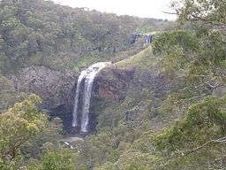 Upper and lower Ebor Falls, within Guy Fawkes River National Park, 2008 | |
| Name origin: Explored by European settlers on Guy Fawkes Day, 1845[2] | |
| Country | Australia |
|---|---|
| State | New South Wales |
| IBRA | New England Tablelands |
| Districts | New England, Northern Tablelands |
| Municipality | Guyra |
| Part of | Clarence River catchment |
| Tributaries | |
| - left | Aberfoyle River, Doughboy Creek |
| - right | Pantons Creek, Marengo Creek |
| Source | Snowy Range, Great Dividing Range |
| - location | southeast of Ebor |
| - elevation | 1,410 m (4,626 ft) |
| Mouth | confluence with the Sara River to form the Boyd River |
| - location | within Guy Fawkes River National Park |
| - elevation | 304 m (997 ft) |
| Length | 101 km (63 mi) |
| National park | Guy Fawkes River NP |
| Waterfall | Ebor Falls |
| [3] | |
Guy Fawkes River, a perennial stream[1] that is part of the Clarence River catchment, is located in the New England and Northern Tablelands districts of New South Wales, Australia.
Course and features
Guy Fawkes River rises below Majors Point, on the northern slopes of the Snowy Range, an eastern spur of the Great Dividing Range, east of the village of Ebor. The river spills over the 115 metres (377 ft) columned basalt rock Ebor Falls,[4] and enters a deep valley, joined by four tributaries, including Aberfoyle River, flowing generally northward and eventually forming its confluence with the Sara River to form the Boyd River. The river descends 1,110 metres (3,640 ft) over its 101 kilometres (63 mi) course;[3] and passes below Round Mountain, the highest peak of the Northern Tablelands.
The course of the river generally runs from the south to north along the valley of the Demon Fault Line, within the Guy Fawkes River National Park.[5] Adjoining the national park are the Guy Fawkes River Nature Reserve and Guy Fawkes River State Conservation Area.
The Bicentennial National Trail runs along the western side of Guy Fawkes River on what is a travelling stock route.[6]
The largest of the Grevillea genus, Southern Silky Oak, or Grevillea robusta, is distributed in the Guy Fawkes River area, which is the southern limit of its natural environment. It has attractive orange-yellow flowers and may reach up to 35 metres (115 ft) with a trunk diameter in excess of 1 metre (3 ft 3 in).[7]
Name
The river is named after Guy Fawkes. Major Edward Parke named the Guy Fawkes River after camping nearby on Guy Fawkes Day, 5 November 1845.[2]
See also
References
- 1 2 "Guy Fawkes River". Geographical Names Register (GNR) of NSW. Geographical Names Board of New South Wales. Retrieved 1 March 2013.
- 1 2 "Why you should visit". Guy Fawkes River National Park. NSW National Parks & Wildlife Service. Retrieved 1 March 2013.
- 1 2 "Guy Fawkes River, NSW". Bonzle Digital Atlas of Australia. Retrieved 1 March 2013.
- ↑ "Dorrigo: Things to see". The Sydney Morning Herald. 8 February 2004. Retrieved 1 March 2013.
- ↑ Guy Fawkes River National Park (leaflet ed.). NSW National Parks & Wildlife Service. 2004.
- ↑ "Guy Fawkes". NSW Wilderness Index. The Colong Foundation for Wilderness Ltd. September 1999. Retrieved 8 December 2008.
- ↑ Floyd, A. G (1978). Grevillea robusta (PDF). NSW Rainforest Trees: Research Note No. 35. Forestry Commission of New South Wales. p. 14. ISSN 0085-3984. Retrieved 1 March 2013.
External links
- "Guy Fawkes River National Park, Nature Reserve and State Conservation Area: Plan of management" (PDF). NSW National Parks & Wildlife Service. NSW Department of Environment and Climate Change. January 2009. ISBN 978-1-74232-158-5.
River systems and rivers of the Northern Rivers catchments, New South Wales, Australia | |||||||
|---|---|---|---|---|---|---|---|
| |||||||
| |||||||
| |||||||
| |||||||
| |||||||
| |||||||
| |||||||
|
Coordinates: 29°57′S 152°16′E / 29.950°S 152.267°E