Guil
For the village in Iran, see Guil, Iran.
| Guil | |
|---|---|
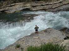 The Guil. | |
| Country | France |
| Basin | |
| Main source |
Ristolas 2,510 m (8,230 ft) 44°41′14″N 07°03′56″E / 44.68722°N 7.06556°E |
| River mouth |
Durance 875 m (2,871 ft) 44°40′01″N 06°36′05″E / 44.66694°N 6.60139°ECoordinates: 44°40′01″N 06°36′05″E / 44.66694°N 6.60139°E |
| Progression | Durance→ Rhône→ Mediterranean Sea |
| Basin size | 630 km2 (240 sq mi) |
| Physical characteristics | |
| Length | 51.6 km (32.1 mi) |
| Discharge |
|
The Guil (French: le Guil) is a 51.6-kilometre (32.1 mi) long river in the Hautes-Alpes département, southeastern France. Its source is several small streams which converge into the lake Lestio, at Ristolas. It flows generally west, through the Queyras. It is a left tributary of the Durance into which it flows at Guillestre.
Communes along its course
This list is ordered from source to mouth: Ristolas, Abriès, Aiguilles, Château-Ville-Vieille, Arvieux, Eygliers, Guillestre
Notes
- This article is based on the equivalent article from the French Wikipedia, consulted on 23 April 2009.
References
| Wikimedia Commons has media related to Guil. |
This article is issued from Wikipedia - version of the 5/21/2016. The text is available under the Creative Commons Attribution/Share Alike but additional terms may apply for the media files.