Kortessem
| Kortessem | |||
|---|---|---|---|
| Municipality | |||
 | |||
| |||
 Kortessem Location in Belgium | |||
|
Location of Kortessem in Limburg  | |||
| Coordinates: 50°52′N 05°23′E / 50.867°N 5.383°ECoordinates: 50°52′N 05°23′E / 50.867°N 5.383°E | |||
| Country | Belgium | ||
| Community | Flemish Community | ||
| Region | Flemish Region | ||
| Province | Limburg | ||
| Arrondissement | Tongeren | ||
| Government | |||
| • Mayor | Hugo Philtjens (VLD) | ||
| • Governing party/ies | VLD | ||
| Area | |||
| • Total | 33.90 km2 (13.09 sq mi) | ||
| Population (1 January 2016)[1] | |||
| • Total | 8,359 | ||
| • Density | 250/km2 (640/sq mi) | ||
| Postal codes | 3720-3724 | ||
| Area codes | 011 | ||
| Website | www.kortessem.be | ||


Kortessem (Limburgish: Kotsoeve) is a municipality located in the Belgian province of Limburg near Hasselt. On January 1, 2006, Kortessem had a total population of 8,074. The total area is 33.90 km² which gives a population density of 238 inhabitants per km².
The municipality consists of the following sub-municipalities: Kortessem, Guigoven, Vliermaal, Vliermaalroot, and Wintershoven.
Up until its destruction by a storm in 2009, Kortessem was the home of the Onzelievehereboom: a 1200-year-old oak.
Gallery
-

Church of Saint Peter in Chains in Wintershoven, Kortessem
-
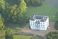
Castle Jongenbos, Vliermaalroot
References
- ↑ Population per municipality as of 1 January 2016 (XLS; 397 KB)
External links
-
 Media related to Kortessem at Wikimedia Commons
 - Official website
- Kovok Kortessem: Volleybalteam
- kortessem.2link.be
 |
Hasselt | Diepenbeek | | |
| Alken Wellen |
|
Hoeselt | ||
| ||||
| | ||||
| Borgloon | |
Tongeren |

This article is issued from Wikipedia - version of the 12/1/2016. The text is available under the Creative Commons Attribution/Share Alike but additional terms may apply for the media files.