Gelderland
| Gelderland | |||
|---|---|---|---|
| Province of the Netherlands | |||
| |||
|
Anthem: "Ons Gelderland" "Our Gelderland" | |||
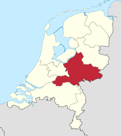 Location of Gelderland in the Netherlands | |||
| Coordinates: 52°04′N 5°57′E / 52.06°N 5.95°ECoordinates: 52°04′N 5°57′E / 52.06°N 5.95°E | |||
| Country | Netherlands | ||
| Capital | Arnhem | ||
| Largest city | Nijmegen | ||
| Government | |||
| • King's Commissioner | Clemens Cornielje (VVD) | ||
| Area | |||
| • Land | 4,971.76 km2 (1,919.61 sq mi) | ||
| • Water | 164.75 km2 (63.61 sq mi) | ||
| Area rank | 1 | ||
| Population (1 January 2015) | |||
| • Land | 2,026,578 | ||
| • Rank | 4th | ||
| • Density | 410/km2 (1,100/sq mi) | ||
| • Density rank | 6th | ||
| ISO 3166 code | NL-GE | ||
| Religion (1999) | 31% Protestant, 29% Catholic | ||
| Website | www.gelderland.nl | ||

Gelderland (Dutch pronunciation: [ˈɣɛldərˌlɑnt], also Guelders in English) is a province of the Netherlands, located in the central eastern part of the country. With a land area of nearly 5,000 km2, it is the largest province of the Netherlands and shares borders with six other provinces and Germany.
The capital is Arnhem. However, both Nijmegen and Apeldoorn are larger cities, Nijmegen being the largest with nearly 170,000 inhabitants. Other major regional centres in Gelderland are Ede, Doetinchem, Zutphen, Tiel, Wageningen, Zevenaar, Winterswijk and Harderwijk.
Gelderland had a population of just over two million in 2015.[1]
History
According to the Wichard saga, the city was named by the Lords of Pont who fought and killed a dragon in 878 AD. They named the town they founded after the death rattle of the dragon: "Gelre!"[2]
Historically, the province dates from states of the Holy Roman Empire and takes its name from the nearby German city of Geldern.
The County of Guelders arose out of the Frankish pagus Hamaland in the 11th century around castles near Roermond and the town of Geldern. The counts of Gelre acquired the Betuwe and Veluwe regions and, through marriage, the County of Zutphen. Thus the counts of Guelders laid the foundation for a territorial power that, through control of the Rhine, Waal, Meuse and IJssel rivers, was to play an important role in the later Middle Ages. The geographical position of their territory dictated the external policy of the counts during the following centuries; they were committed to the interests of the Holy Roman Empire and to expansion south and west.
Further enlarged by the acquisition of the imperial city of Nijmegen in the 13th century, the countship was raised to a duchy in 1339 by the Holy Roman Emperor, Louis IV. After 1379, the duchy was ruled from Jülich and by the counts of Egmond and Cleves. The duchy resisted Burgundian domination, but William, Duke of Jülich-Cleves-Berg was forced to cede it to Charles V in 1543, after which it formed part of the Burgundian-Habsburg hereditary lands.[3]
The duchy revolted with the rest of the Netherlands against Philip II of Spain and joined the Union of Utrecht (1579). After the deposition of Philip II, its sovereignty was vested in the States of Gelderland, and the princes of Orange were stadtholders. In 1672, the province was temporarily occupied by Louis XIV and, in 1713, the southeastern part including the ducal capital of Geldern fell to Prussia. Part of the Batavian Republic (1795–1806), of Louis Bonaparte’s Kingdom of Holland (1806–10), and of the French Empire (1810–13), Gelderland became a province of the Kingdom of the Netherlands in 1815.[3]
During the Second World War, it saw heavy fighting between Allied Paratroopers, British XXX Corps and the German II SS Panzer Corps, at the Battle of Arnhem.
Geography
Gelderland can roughly be divided into four geographical regions: the Veluwe in the north, Rivierenland including the Betuwe in the southwest, the Achterhoek (literally meaning the "back corner") or Graafschap (which originally means earldom or county) in the east and the city-region Arnhem - Nijmegen.
Municipalities
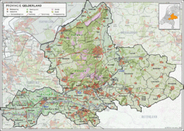
In 2015, the 54 municipalities in Gelderland were:
- Veluwe COROP group
- South West Gelderland COROP group
- Achterhoek COROP group
- Arnhem & Nijmegen COROP group
Abolished municipalities
These municipalities were merged with neighbouring ones:
- Angerlo was merged into Zevenaar
- Dinxperlo was merged into Aalten
- Gorssel was merged into Lochem
- Hoevelaken was merged into Nijkerk
- Lichtenvoorde was merged into Groenlo (renamed Oost Gelre in 2006)
- Warnsveld was merged into Zutphen
- Wehl was merged into Doetinchem
- Millingen aan de Rijn and Ubbergen were merged into Groesbeek (renamed Berg en Dal in 2016)
These municipalities were merged and given a new name:
- Borculo, Eibergen, Neede and Ruurlo have become Berkelland
- Hengelo, Hummelo en Keppel, Steenderen, Vorden and Zelhem have become Bronckhorst
- Bergh and Didam has become Montferland
- Gendringen and Wisch have become Oude IJsselstreek
Cultural references
In the 2001 movie A Knight's Tale, the protagonist, William Thatcher (played by Heath Ledger) pretends to be a knight known as "Ulrich von Lichtenstein from Gelderland".
References
- ↑ "Regionale kerncijfers Nederland" (in Dutch). CBS. Retrieved 30 May 2015.
- ↑ Geldersche volksalmanak Volumes 21-22; Nijhoff & son; 1855
- 1 2 "Gelderland". Britannica.com. Retrieved 13 July 2015.
External links
| Wikimedia Commons has media related to Gelderland. |
| Wikivoyage has a travel guide for Gelderland. |
 |
Flevoland | Overijssel | | |
| Utrecht | |
North Rhine-Westphalia (DE) | ||
| ||||
| | ||||
| South Holland | North Brabant | Limburg |


 | ||