Guatemala–Mexico border

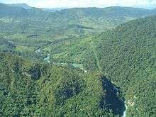
The Guatemala–Mexico border is the international border between Guatemala and Mexico. It measures 871 km (541 mi) and runs between north and west Guatemala (the Guatemalan departments of San Marcos, Huehuetenango, El Quiché and El Petén) and the Mexican states of Quintana Roo, Campeche, Tabasco and Chiapas. The border includes stretches of the Usumacinta River, the Salinas River, and the Suchiate River.
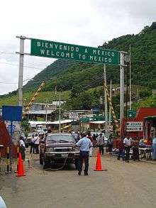
There is no wall on the border, although there are sections of fence near official border crossings.[1]

Geopolitically, this border represents much of the western and northern boundary of the region of Central America within North America. It is across this border that most of the commerce between Mexico and Guatemala and the rest of Central America takes place.
History
In 1881, problems arose for Guatemala when President Justo Rufino Barrios claimed lands Soconusco and Chiapas. The initial position of the Government of Mexico was not to accept discussion about their rights in that region. However, from 1882 began talks to resolve the problem between Matías Romero and Justo Rufino at The Winch at Hacienda de Barrios (Soconusco), where both had possessions. They decided to go to arbitration in the United States.
The preliminary agreement was signed in New York City on August 12 of 1882, and it stated that: "The Republic of Guatemala dispenses with the argument that has held about his rights to the territory of Chiapas and Soconusco department." The position of Mexico is well seated in their rights of those territories. The final boundary treaty was signed in Mexico City on September 27 of 1882. The first article provides that: "The Republic of Guatemala forever renounce rights that judges have on the territory of the State of Chiapas and Soconusco your district, and therefore considers the territory as part of the United Mexican States." As for the delineation of the border itself, Mexico and Guatemala agreed to use straight lines between key points known and accepted by both countries. The measurement and demarcation work was completed in 1902. Soconusco in Guatemala advanced to the Suchiate river and Mexico received the county of Motozintla.
False rumors of wall during 2016 U.S. presidential campaign
During the 2016 U.S. presidential campaign, some conservative and alt-right social media pages ran stories stating that Mexico had built a wall on the Guatemala–Mexico border, supporting an argument that it was logical that there should also be an end-to-end wall on the U.S.–Mexico border.[2] One of the most widely circulated pictures of the purported "Mexico–Guatemala Border Wall" was in reality of the Israeli West Bank barrier. In fact there is no wall on Mexico's border with Guatemala, although there are sections of fence near official border crossings,[1] facts presented by Snopes.[2] On July 24, 2016 the Reynosa, Mexico, newspaper El Mañana published an article advocating for an end-to-end fence on Mexico's southern border,[3][4] and there were reports that in 2010 the Mexican state of Chiapas was considering building one.[5]
Immigration issues
In 2006, Joseph Contreras profiled the issue of Guatemalan immigrants illegally entering Mexico for Newsweek magazine and pointed out that while Mexican president Vicente Fox demanded that the United States grant legal residency to millions of illegal Mexican immigrants, Mexico had only granted legal status to 15,000 illegal immigrants. Additionally, Contreras found that at coffee farms in the Mexican state Chiapas, "40,000 Guatemalan field hands endure backbreaking jobs and squalid living conditions to earn roughly [US]$3.50 a day" and that some farmers "even deduct the cost of room and board from that amount."[6] The Mexican National Institute of Migration estimated that 400,235 people crossed the border illegally every year and that around 150,000 of them intended to enter the United States.[7]
Gun and drug running
The border with Guatemala is the primary source of military grade weaponry - including anti-tank rockets, hand grenades, plastic explosives, and grenade launchers - used by the Mexican drug cartels. The weapons are typically stolen from Central American government munitions stockpiles.[8] A 2010 U.S. diplomatic cable disclosed by WikiLeaks states that Mexico does not have sufficient resources to patrol the border with only 125 officers to monitor the entire 577-mile border.[9] Mexican officials confirm that they do not have sufficient resources as they have been concentrating their efforts on fighting the cartels in the North.[10]
Cities and Border crossing
In 2014, Mexico's border with Guatemala and Belize had 11 formal crossings (10 with Guatemala and 1 with Belize) and more than 370 informal crossings.[11] As part of an effort known as Plan Frontera Sur (Southern Border Plan), which is intended to limit illegal Central American entry into the country, Mexico will increase the number of formal crossings.[11]
Guatemala and Mexico had 10 formal border crossings in 2004:
- Ciudad Hidalgo, Chiapas - Ciudad Tecún Umán, San Marcos
- Talismán, Chiapas - El Carmen, San Marcos
- Union Juárez, Chiapas - Toquían Grande, San Marcos
- Mazapa de Madero, Chiapas- Sibinal, San Marcos
- Ciudad Cuahtemoc, Chiapas - La Mesilla, Huehuetenango
- Carmen Xhán, Chiapas - Gracias a Dios, Huehuetenango
- Nuevo Orizaba, Chiapas - Ingenieros, El Quiché
- Frontera Corozal, Chiapas - Bethel, El Petén
- El Ceibo, Tabasco - El Ceibo, El Petén
- El Martillo, Tabasco - El Naranjo, El Petén
See also
References
- 1 2 Nathaniel Parish Flannery, "As Mexico tightens its southern border, Central American migrants find new routes north", Fusion.net
- 1 2 "Border Disorder: a photograph purportedly showing a border wall between Mexico and Guatemala actually pictures a portion of the Israeli West Bank barrier", May 2016, Snopes website
- ↑ "Sí al muro fronterizo… Pero en el sur de México" ("Yes to the border wall, but in southern Mexico"), July 24, 2016, El Mañana (Reynosa, Mexico)
- ↑ "Mexican Newspaper Supports Trump’s Wall, But on Southern Border with Guatemala", PanAm Post, July 28, 2016
- ↑ "Another Wall Blocks Route to U.S.", Danilo Valladares, September 15, 2010, InterPress News Agency
- ↑ Contreras, Joseph (June 5, 2006), "Stepping Over the Line", Newsweek, 147 (23), p. 72
- ↑ Gorney, Cynthia (February 2008), "Mexico's Other Border", National Geographic, 213 (2), pp. 60–79
- ↑ McClatchyDC: "Mexican cartels amass better arsenals, mostly bought in U.S." by Tim Johnson November 18, 2010
- ↑ El Paso Times: "Document: Mexico can't control border" by Diana Washington Valdez December 10, 2010
- ↑ McClatchyDC: "Headless corpses spark worries on Mexico's southern border" by Tim Johnson May 26, 2011
- 1 2 Lakhani, Nina. "Mexico deports record numbers of women and children in US-driven effort". The Guardian. Retrieved 4 February 2015.
Coordinates: 17°48′45″N 89°08′55″W / 17.8125°N 89.1486°W