Guadalupe River State Park
| Guadalupe River State Park | |
|---|---|
|
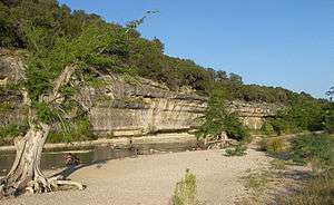
A bluff in Guadalupe River State Park | |
 | |
| Location | Comal County / Kendall County, Texas |
| Nearest city | Bulverde |
| Coordinates | 29°52′29″N 98°30′16″W / 29.87472°N 98.50444°WCoordinates: 29°52′29″N 98°30′16″W / 29.87472°N 98.50444°W |
| Area | 1,938.7 acres (785 ha) |
| Established | 1983 |
| Governing body | Texas Parks and Wildlife Department |
Guadalupe River State Park is a Texas state park located on a section of the Guadalupe River in Kendall and Comal Counties, northwest of Bulverde, Texas United States and is administered by the Texas Parks and Wildlife Department. The land was acquired by deed from private owners in 1974 and was opened to the public in 1983.
Features
The park has four miles of river frontage for canoeing, fishing, swimming and tubing. Other activities include picnicking, hiking, birdwatching and camping. There is a 5.3 mile equestrian trail that can also be used for mountain biking. There is a two-hour guided interpretive tour of the adjacent Honey Creek State Natural Area.
Flora
Bald Cypress, sycamores, pecan, live oak, ashe juniper, and mesquite can be found in the park.
Fauna
White-tailed deer are common throughout the park, as well as raccoons, armadillos, and skunks. The Ashe juniper woodland provides nesting grounds for the endangered golden-cheeked warbler. Many other bird species are found in the park also.
 A cypress tree on the banks of the Guadalupe River. |
External links
- Texas Parks and Wildlife: Guadalupe River State Park
- Geology and Hydrostratigraphy of Guadalupe River State Park and Honey Creek State Natural Area, Kendall and Comal Counties, Texas United States Geological Survey