Guadalupe (Spain)
| Guadalupe (Río Guadalupe) | |
|---|---|
|
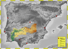
The watershed of the Guadiana | |
| Other name(s) | Guadalupejo |
| Country | Spain |
| Basin | |
| Main source |
Sierra de Villuercas, Cáceres Province Extremadura 1157 |
| River mouth |
Garcia de Sola Dam, Guadiana Valdecaballeros municipality, Badajoz Province 391 39°14′15″N 5°8′58″W / 39.23750°N 5.14944°WCoordinates: 39°14′15″N 5°8′58″W / 39.23750°N 5.14944°W |
| Progression | Guadiana - Atlantic Ocean |
| River system | Guadiana |
| Physical characteristics | |
| Length | 40.56 kilometres (25.20 mi) |
The Guadalupe or Guadalupejo river (Spanish: Río Guadalupe) is a right hand tributary of the Guadiana, in Spain.
Course
The Guadalupe has its sources in the Sierra de Villuercas near Guadalupe, giving its name to the town, and by extension to the monastery of Santa María de Guadalupe.
It flows southwards into the Guadiana at the Garcia de Sola Dam, barely 1.5 km east of Valdecaballeros. There is an abandoned nuclear power plant, the Valdecaballeros Nuclear Power Plant, as well as a small dam near its mouth.[1]
Etymology
The name is believed to be derived from the Arabic phrase وادي اللب, "Wad-al-lubb" ("hidden river"), because the river narrows down as it flows near to the town of Guadalupe.
An alternate and incorrect etymological explanation which is commonly found on the internet states that the name may have derived from the Arabic word for "valley" or "river" (wadi) and the Latin word lupus, meaning wolf.[2]