Gu-Win, Alabama
| Gu-Win, Alabama | |
|---|---|
| Town | |
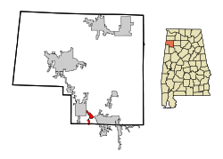 Location in Marion County and the state of Alabama | |
| Coordinates: 33°56′58″N 87°52′18″W / 33.94944°N 87.87167°W | |
| Country | United States |
| State | Alabama |
| Counties | Fayette, Marion |
| Area | |
| • Total | 1.9 sq mi (5 km2) |
| • Land | 1.9 sq mi (5 km2) |
| • Water | 0 sq mi (0 km2) |
| Elevation | 554 ft (169 m) |
| Population (2000) | |
| • Total | 204 |
| • Density | 107.4/sq mi (40.8/km2) |
| Time zone | Central (CST) (UTC-6) |
| • Summer (DST) | CDT (UTC-5) |
| FIPS code | 01-32536 |
| GNIS feature ID | 0119450 |
Gu-Win is a town in Fayette and Marion counties in the U.S. state of Alabama. It incorporated in 1956.[1] At the 2010 census the population was 176, down from 204. Despite occupying a small amount of land in Fayette County, all of the population resides in Marion County.[2]
The town's unusual[3] name is taken from part of two neighboring cities, Guin and Winfield. "Gu-Win" and "Guin" are not the same, though the pronunciation is virtually the same, leading to occasional confusion by visitors.
History
The area Gu-Win occupies is between Guin and Winfield. Until the 1950s, it was initially known as Ear Gap. Not wanting to be annexed into Guin, it pursued incorporation for itself, and chose the name of the local drive-in theater, "Gu-Win."[4] As of 2016, the theatre still operates, but has been renamed the Blue Moon.[5]
Geography
Gu-Win is located at 33°56′58″N 87°52′19″W / 33.94944°N 87.87194°W (33.949505, -87.871921).[6]
According to the U.S. Census Bureau, the town has a total area of 1.9 square miles (4.9 km2), all land.
Demographics
| Historical population | |||
|---|---|---|---|
| Census | Pop. | %± | |
| 1960 | 80 | — | |
| 1970 | 231 | 188.8% | |
| 1980 | 266 | 15.2% | |
| 1990 | 243 | −8.6% | |
| 2000 | 204 | −16.0% | |
| 2010 | 176 | −13.7% | |
| Est. 2015 | 173 | [7] | −1.7% |
| U.S. Decennial Census[8] 2013 Estimate[9] | |||
As of the census[10] of 2000, there were 204 people, 86 households, and 63 families residing in the town. The population density was 106.4 people per square mile (41.0/km²). There were 100 housing units at an average density of 52.1 per square mile (20.1/km²). The racial makeup of the town was 100.00% White. 2.94% of the population were Hispanic or Latino of any race.
There were 86 households out of which 31.4% had children under the age of 18 living with them, 62.8% were married couples living together, 8.1% had a female householder with no husband present, and 25.6% were non-families. 25.6% of all households were made up of individuals and 14.0% had someone living alone who was 65 years of age or older. The average household size was 2.37 and the average family size was 2.81.
In the town the population was spread out with 20.1% under the age of 18, 10.3% from 18 to 24, 29.9% from 25 to 44, 20.1% from 45 to 64, and 19.6% who were 65 years of age or older. The median age was 38 years. For every 100 females there were 108.2 males. For every 100 females age 18 and over, there were 94.0 males.
The median income for a household in the town was $29,375, and the median income for a family was $42,500. Males had a median income of $39,375 versus $18,906 for females. The per capita income for the town was $16,868. About 11.3% of families and 9.9% of the population were below the poverty line, including 5.3% of those under the age of eighteen and 6.8% of those sixty five or over.
References
- ↑ http://www.al.com/living/index.ssf/2015/05/the_curious_tales_of_4_oddly_n.html
- ↑ http://www.census.gov/prod/cen2010/cph-1-2.pdf
- ↑ Thompson, George E. (1 July 2009). You Live Where?: Interesting and Unusual Facts about where We Live. iUniverse. p. 2. ISBN 978-1-4401-3421-0.
- ↑ http://www.al.com/living/index.ssf/2015/05/the_curious_tales_of_4_oddly_n.html
- ↑ https://www.facebook.com/bmdrivein/
- ↑ "US Gazetteer files: 2010, 2000, and 1990". United States Census Bureau. 2011-02-12. Retrieved 2011-04-23.
- ↑ "Annual Estimates of the Resident Population for Incorporated Places: April 1, 2010 to July 1, 2015". Retrieved July 2, 2016.
- ↑ "U.S. Decennial Census". Census.gov. Retrieved June 6, 2013.
- ↑ "Annual Estimates of the Resident Population: April 1, 2010 to July 1, 2013". Retrieved June 3, 2014.
- ↑ "American FactFinder". United States Census Bureau. Retrieved 2008-01-31.
Coordinates: 33°56′58″N 87°52′19″W / 33.949505°N 87.871921°W
Municipalities and communities of Fayette County, Alabama, United States | ||
|---|---|---|
| Cities | 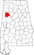 | |
| Towns | ||
| Unincorporated communities | ||
| Footnotes | ‡This populated place also has portions in an adjacent county or counties | |
Municipalities and communities of Marion County, Alabama, United States | ||
|---|---|---|
| Cities |  | |
| Towns | ||
| Unincorporated communities | ||
| Ghost town | ||
| Footnotes | ‡This populated place also has portions in an adjacent county or counties | |