Guémar
| Guémar | ||
|---|---|---|
| ||
 Guémar | ||
|
Location within Grand Est region  Guémar | ||
| Coordinates: 48°11′22″N 7°23′51″E / 48.1894°N 7.3975°ECoordinates: 48°11′22″N 7°23′51″E / 48.1894°N 7.3975°E | ||
| Country | France | |
| Region | Grand Est | |
| Department | Haut-Rhin | |
| Arrondissement | Colmar-Ribeauvillé | |
| Canton | Sainte-Marie-aux-Mines | |
| Intercommunality | Pays de Ribeauvillé | |
| Government | ||
| • Mayor (2008–2014) | Umberto Stamile | |
| Area1 | 18.22 km2 (7.03 sq mi) | |
| Population (2006)2 | 1,377 | |
| • Density | 76/km2 (200/sq mi) | |
| Time zone | CET (UTC+1) | |
| • Summer (DST) | CEST (UTC+2) | |
| INSEE/Postal code | 68113 / 68970 | |
| Elevation | 172–193 m (564–633 ft) | |
|
1 French Land Register data, which excludes lakes, ponds, glaciers > 1 km² (0.386 sq mi or 247 acres) and river estuaries. 2 Population without double counting: residents of multiple communes (e.g., students and military personnel) only counted once. | ||
.svg.png)

Church in Guémar
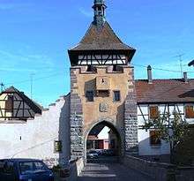
Medieval timber-framed city gate in Guémar

Fountain
Guémar (German: Gemar) is a commune in the Haut-Rhin department in Grand Est in north-eastern France.
See also
References
External links
| Wikimedia Commons has media related to Guémar. |
This article is issued from Wikipedia - version of the 11/13/2016. The text is available under the Creative Commons Attribution/Share Alike but additional terms may apply for the media files.