Gschnitz
| Gschnitz | ||
|---|---|---|
 | ||
| ||
 Gschnitz Location within Austria | ||
Location in the district
| ||
| Coordinates: 47°02′39″N 11°20′58″E / 47.04417°N 11.34944°ECoordinates: 47°02′39″N 11°20′58″E / 47.04417°N 11.34944°E | ||
| Country | Austria | |
| State | Tyrol | |
| District | Innsbruck Land | |
| Government | ||
| • Mayor | Christian Felder | |
| Area | ||
| • Total | 59.1 km2 (22.8 sq mi) | |
| Elevation | 1,242 m (4,075 ft) | |
| Population (1 January 2016)[1] | ||
| • Total | 424 | |
| • Density | 7.2/km2 (19/sq mi) | |
| Time zone | CET (UTC+1) | |
| • Summer (DST) | CEST (UTC+2) | |
| Postal code | 6150 | |
| Area code | 05276 | |
| Vehicle registration | IL | |
| Website | www.gschnitz.eu | |


Gschnitz is a municipality with 415 inhabitants (1 January 2011) [2] in the southern part of the District Innsbruck-Land and is located 25 km south of Innsbruck.
Setting
Gschnitz is placed at the end of the valley of the same name which branches off from the Wipptal at Steinach am Brenner. The municipality borders cross from the Talschluss (3277 m.) to the South Tyrol. The Gschnitz brook provides the village with drinking water.
Nearby municipalities
Brenner, Neustift im Stubaital, Obernberg am Brenner, Trins.
History
Origin
The village is mentioned for the first time in 1284 as "Gasnitz". In 1288 the valley bought nine "Schwaighöfe”, alpine farms, seven of them in Gschnitz, which formed the centre of the village, and two at Laponesalm. The right of succession in Tirol originated from these nine Schwaighöfe and was adopted in all the other valleys in the region. In 1471 the rivalry between Gschnitz and Trins arisen and reached a point that the inhabitants of the two villages blocked the entrance to the valley; the Steinach am Brenner Court had to intervene to redeem the dispute. Gschnitz was awarded the title of Municipality in 1811. Major development occurred from the 18th century onward.[3]
Coats-of-arms
Gschnitz coat of arms consists of a red background, crossed by three horizontal stripes, one of each, consisting of six lozenges, alternating white and black. This visualization looks like the roof of the nine mountain farms. The coat of arms was made official January 10, 1984 [4]
Population
| Historical population | ||
|---|---|---|
| Year | Pop. | ±% |
| 1869 | 210 | — |
| 1880 | 222 | +5.7% |
| 1890 | 221 | −0.5% |
| 1900 | 194 | −12.2% |
| 1910 | 217 | +11.9% |
| 1923 | 207 | −4.6% |
| 1934 | 230 | +11.1% |
| 1939 | 246 | +7.0% |
| 1951 | 278 | +13.0% |
| 1961 | 291 | +4.7% |
| 1971 | 371 | +27.5% |
| 1981 | 436 | +17.5% |
| 1991 | 443 | +1.6% |
| 2001 | 455 | +2.7% |
| 2011 | 415 | −8.8% |
Sights

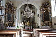
Parish Our Lady of Snow
Gschnitz originally belonged, like most of the villages of Wipptal, to the parish of Matrei am Brenner. The church “Our Lady of the Snow" was built in 1730 and later, in 1755, restored in Baroque style with plans by Franz de Paula Penz. In 1775 Gschnitz was established as Vicariate and in 1891 as Parish.
Sanctuary of St. Magdalena
The Sanctuary of "St. Magdalena" is located near the border, between Gschnitz and Trins, at an altitude of 1661 m. accessible only on foot, under the Schönberg. The church is the oldest in the valley as confirmed by the Romanesque frescoes dating back around 1200 and discovered in 1959.
References
- ↑ Statistik Austria - Bevölkerung zu Jahresbeginn 2002-2016 nach Gemeinden (Gebietsstand 2016-01-01), 2016-01-01.
- ↑ (German) Statistik Austria: Gschnitz
- ↑ (German) Town History
- ↑ (English) Heraldry of the World, Gschnitz
External links
| Wikimedia Commons has media related to Gschnitz. |
- (English) Wipptal Gschnitz