Grundy County, Iowa
| Grundy County, Iowa | |
|---|---|
|
| |
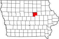 Location in the U.S. state of Iowa | |
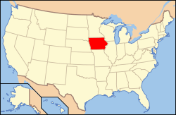 Iowa's location in the U.S. | |
| Founded | 1851 |
| Named for | Felix Grundy |
| Seat | Grundy Center |
| Largest city | Grundy Center |
| Area | |
| • Total | 502 sq mi (1,300 km2) |
| • Land | 502 sq mi (1,300 km2) |
| • Water | 0.04 sq mi (0 km2), 0.01% |
| Population | |
| • (2010) | 12,453 |
| • Density | 25/sq mi (10/km²) |
| Congressional district | 4th |
| Time zone | Central: UTC-6/-5 |
| Website |
www |
Grundy County is a county located in the U.S. state of Iowa. As of the 2010 census, the population was 12,453.[1] The county seat is Grundy Center.[2] The county is named for Felix Grundy, former U.S. Attorney General.[3]
Grundy County is included in the Waterloo-Cedar Falls, IA Metropolitan Statistical Area.[4]
History
Grundy County was formed on January 15, 1851, and became self-governing in 1856. It was named after Felix Grundy of Tennessee, a statesman, Senator, member of the House of Representatives and Attorney General under President James K. Polk.
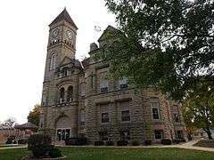
The first courthouse was built in 1861. The wooden, two-story building contained a courtroom, but was used for other purposes, including housing the office of the sheriff, county treasurer, the judge, as well as a chamber for the jury. The cornerstone for a second courthouse was laid on November 11, 1891.[5]
Geography
According to the U.S. Census Bureau, the county has a total area of 502 square miles (1,300 km2), of which 502 square miles (1,300 km2) is land and 0.04 square miles (0.10 km2) (0.01%) is water.[6]
Major highways
Adjacent counties
- Butler County (north)
- Black Hawk County (east)
- Tama County (southeast)
- Marshall County (southwest)
- Hardin County (west)
Demographics
| Historical population | |||
|---|---|---|---|
| Census | Pop. | %± | |
| 1860 | 793 | — | |
| 1870 | 6,399 | 706.9% | |
| 1880 | 12,639 | 97.5% | |
| 1890 | 13,215 | 4.6% | |
| 1900 | 13,757 | 4.1% | |
| 1910 | 13,574 | −1.3% | |
| 1920 | 14,420 | 6.2% | |
| 1930 | 14,133 | −2.0% | |
| 1940 | 13,518 | −4.4% | |
| 1950 | 13,722 | 1.5% | |
| 1960 | 14,132 | 3.0% | |
| 1970 | 14,119 | −0.1% | |
| 1980 | 14,366 | 1.7% | |
| 1990 | 12,029 | −16.3% | |
| 2000 | 12,369 | 2.8% | |
| 2010 | 12,453 | 0.7% | |
| Est. 2015 | 12,435 | [7] | −0.1% |
| U.S. Decennial Census[8] 1790-1960[9] 1900-1990[10] 1990-2000[11] 2010-2013[1] | |||
2010 census
The 2010 census recorded a population of 12,453 in the county, with a population density of 24.7816/sq mi (9.5682/km2). There were 5,530 housing units, of which 5,131 were occupied.[12]
2000 census
As of the census[13] of 2000, there were 12,369 people, 4,984 households, and 3,583 families residing in the county. The population density was 25 people per square mile (10/km²). There were 5,304 housing units at an average density of 11 per square mile (4/km²). The racial makeup of the county was 98.97% White, 0.08% Black or African American, 0.02% Native American, 0.29% Asian, 0.15% from other races, and 0.48% from two or more races. 0.58% of the population were Hispanic or Latino of any race.
There were 4,984 households out of which 30.70% had children under the age of 18 living with them, 63.80% were married couples living together, 5.50% had a female householder with no husband present, and 28.10% were non-families. 25.50% of all households were made up of individuals and 14.20% had someone living alone who was 65 years of age or older. The average household size was 2.45 and the average family size was 2.94.
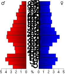
In the county the population was spread out with 25.20% under the age of 18, 6.30% from 18 to 24, 25.10% from 25 to 44, 24.10% from 45 to 64, and 19.30% who were 65 years of age or older. The median age was 41 years. For every 100 females there were 95.70 males. For every 100 females age 18 and over, there were 92.10 males.
The median income for a household in the county was $39,396, and the median income for a family was $46,627. Males had a median income of $32,006 versus $22,003 for females. The per capita income for the county was $19,142. About 3.30% of families and 4.60% of the population were below the poverty line, including 4.60% of those under age 18 and 5.70% of those age 65 or over.
Communities
Townships
- Beaver Township
- Black Hawk Township
- Clay Township
- Colfax Township
- Fairfield Township
- Felix Township
- German Township
- Grant Township
- Lincoln Township
- Melrose Township
- Palermo Township
- Pleasant Valley Township
- Shiloh Township
- Washington Township
Population ranking
The population ranking of the following table is based on the 2010 census of Grundy County.[14]
† county seat
| Rank | City/Town/etc. | Municipal type | Population (2010 Census)
|
|---|---|---|---|
| 1 | † Grundy Center | City | 2,706 |
| 2 | Reinbeck | City | 1,664 |
| 3 | Dike | City | 1,209 |
| 4 | Conrad | City | 1,108 |
| 5 | Wellsburg | City | 707 |
| 6 | Holland | City | 282 |
| 7 | Stout | City | 224 |
| 8 | Beaman | City | 191 |
| 9 | Morrison | City | 94 |
See also
References
- 1 2 "State & County QuickFacts". United States Census Bureau. Retrieved July 17, 2014.
- ↑ "Find a County". National Association of Counties. Retrieved 2011-06-07.
- ↑ Gannett, Henry (1905). The Origin of Certain Place Names in the United States. Govt. Print. Off. p. 145.
- ↑ United States Office of Management and Budget. "Update of Statistical Area Definitions and Guidance on Their Uses" (PDF). pp. 5, 36. Archived from the original (PDF) on 2006-05-14. Retrieved 2006-07-21.
- ↑ http://www.grundycounty.org/features/history.asp
- ↑ "US Gazetteer files: 2010, 2000, and 1990". United States Census Bureau. 2011-02-12. Retrieved 2011-04-23.
- ↑ "County Totals Dataset: Population, Population Change and Estimated Components of Population Change: April 1, 2010 to July 1, 2015". Retrieved July 2, 2016.
- ↑ "U.S. Decennial Census". United States Census Bureau. Retrieved July 17, 2014.
- ↑ "Historical Census Browser". University of Virginia Library. Retrieved July 17, 2014.
- ↑ "Population of Counties by Decennial Census: 1900 to 1990". United States Census Bureau. Retrieved July 17, 2014.
- ↑ "Census 2000 PHC-T-4. Ranking Tables for Counties: 1990 and 2000" (PDF). United States Census Bureau. Retrieved July 17, 2014.
- ↑ "Population & Housing Occupancy Status 2010". United States Census Bureau American FactFinder. Retrieved May 12, 2011.
- ↑ "American FactFinder". United States Census Bureau. Retrieved 2008-01-31.
- ↑ http://www.census.gov/2010census/
External links
| Wikimedia Commons has media related to Grundy County, Iowa. |
- Grundy County, Iowa Official website
 |
Butler County | | ||
| Hardin County | |
Black Hawk County | ||
| ||||
| | ||||
| Marshall County | Tama County |
Municipalities and communities of Grundy County, Iowa, United States | ||
|---|---|---|
| Cities | ||
| Unincorporated communities | ||

Coordinates: 42°24′06″N 92°47′15″W / 42.40167°N 92.78750°W