Fort Heath
| Fort Heath | |
|---|---|
| Part of Harbor Defenses of Boston | |
| location: Winthrop Highlands[1] at Grovers Cliff[2] | |
|
Southeastward view with the face of Grovers Cliff along foreground shore, large rectangular white area on west (right). Pictured items not on the 1921 map include the roads through the barracks area connecting to the off-post intersection that is now the Highland Av & Pond St intersection (right). | |
 Fort Heath Location in Massachusetts | |
| Coordinates |
42°23′22″N 70°58′08″W / 42.389455°N 70.968786°W
|
| Type |
coastal artillery site and radio/radar station eponym: General William Heath (Continental Army)[4] namesake: Fort Heath Apartments |
| Site information | |
| Owner | private and municipal |
| Condition |
private apartment complex and municipal park |
| Site history | |
| Built | c. 1898 |
| In use | 1898-1966 |
| Demolished |
1947 - buildings 1969 - control site tbd - nuclear bunker 1979-1980 - FAA radar & building |
| Battles/wars |
World War I World War II Cold War |

Fort Heath was a US seacoast military installation for defense of the Boston and Winthrop Harbors with an early 20th-century Coast Artillery fort, a 1930s USCG radio station, prewar naval research facilities, World War II batteries, and a Cold War radar station. The fort was part of the Harbor Defenses of Boston (Coast Defenses of Boston 1913-1925) and was garrisoned by the United States Army Coast Artillery Corps. The fort's military structures have been replaced by a residential complex, including the luxurious Forth Heath Apartments, and recreation facilities of Small Park, which has both a commemorative wall and an historical marker for Fort Heath.


Grover's Cliff Military Reservation
The Grover Cliff geodetic survey station marker was emplaced in 1847 (42°23′22.79″N 070°58′08.643″W / 42.3896639°N 70.96906750°W, lost by 1922),[3] and the military site was renamed Grover's Cliff Military Reservation.[7] November 1890 planning for the military site was for 3 artillery rifles and 16 mortars,[8] and by spring 1898 Lieutenant Sewail was in charge of construction.[1] A spur of the Boston, Revere Beach and Lynn Railroad was built to the site by March 29,[9] bids for lumber were received in April,[10] and the "Winthrop Mortar Batteries" of the regular army[11] (Battery F and Battery M) were ordered to Grovers Cliff in May 1898[12] for the 16 mortars, with the batteries encamping May 16 on Cherry Street.[11] Constructed during the Endicott modernization period for fortifications, "the first concrete foundation for one of the disappearing guns at Grovers Cliff" was complete in May 1898,[13] and in 1900 the installation was renamed Fort Heath.[7]
Battery Theodore Winthrop
Battery Theodore Winthrop construction was complete by 1901 with three 12-inch M1888 guns on M1896 disappearing carriages, the heaviest guns in the United States Army Coast Artillery Corps at the time.[14] "Major Morris of the Seventh Heavy Artillery"[15] was the initial commander,[12] and "Batteries P and O of the Regular Army" manned the guns.[16] Additional land was considered in 1901 for a Fort Heath garrison[17] (temporary barracks were on the west side in 1921),[18] and the fort was inspected by the Ordnance Department in 1902.[19]
Fort Heath was a secondary station for a 1907 naval exercise,[20] and in 1908 the Massachusetts Volunteer Militia had a Fort Heath unit.[21] In 1908 the fort had a "range-finders house" and a sea wall was considered[22] (constructed on the south shore by February 1921).[18] In 1917 a "duct line" between Fort Banks and Fort Heath was contracted to New England Telephone and Telegraph,[23] and for 3 batteries—Winthrop and Battery Kellogg & Battery Lincoln at Ft Banks—Ft Heath had the primary base end stations and the Battery Commanders' stations[24] (a commander's station was atop the Ft Heath parapet).[25]
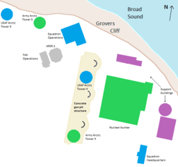
After the 1925 renaming of the Coast Defenses of Boston to the Harbor Defenses of Boston,[26] the fort's ammunition hoists were authorized for disposal in January 1932. A federal survey marker (MY0121—GROVERS) was set in the roof of the southernmost of the three fire control buildings at the fort in line at the northern end of Battery Winthrop. The marker on the "BC" (battery control) structure is roughly indicated on the 1921 map. Gun #3 (the most westerly one) of Battery Winthrop was about 120 ft. southeast of this marker, and the line between this gun and Gun #1 (the most easterly one) was 270 ft. in length.
Coast Guard radio station
The United States Coast Guard radio station at Fort Heath (call sign "NMF") opened on November 12, 1931, and was initially used for testing "traffic…relayed from Point Bonita, California." The station had three 50-foot masts in 1934 (e.g., "Heath Northwest Radio Mast")[27] but as a trial for determining if Navy facilities could instead handle USCG radio traffic, the "station at Winthrop" closed from 1934 to 1936.[28] Subsequently operating "until 1939 when the site was taken over by the Army", the USCG equipment "relocated to a former intelligence monitoring station at North Truro, Massachusetts."[28]
A. A. Battery No. 4
Antiaircraft Artillery Battery No. 4 was designated in 1935 after the 3rd gun pad was constructed in 1934 for 3" AAA guns.[7] The three emplacements were south of a radar and west of the "Theo. Winthrop"[18] foundations, and the three guns were approved on January 8, 1942, to be moved to Fort Ruckman.[7]
Navy Field Test Station
The United States Navy Field Test Station, Fort Heath, established by 1938 included a Massachusetts Institute of Technology research facility for "Fire Control Systems"[29]:240 (cf. Army Signal Corps research at the Twin Lights station at the New Jersey Highlands).
AMTB Battery 945
Anti-Motor Torpedo Boat Battery 945 at the eastern tip of Fort Heath (42°23′18″N 70°58′01″W / 42.388281°N 70.966822°W)[30] covered the northern harbor approaches with a pair of 90 mm Anti-Motor Torpedo Boat (AMTB) guns, and the HHB 3rd Battalion of the 9th Coast Artillery (United States) activated at Fort Heath on June 1, 1941.[31] From September–November 1941 the camouflage training school for the First Coast Artillery District was conducted by the Corps of Engineers at Fort Heath.[32] Gun #1 (42°23′17″N 70°58′01″W / 42.387972°N 70.967081°W)[33] was north of the second gun, and Battery 945 was declared surplus on December 28, 1943 (a very large apartment building is on the Battery 945 position.)
Cold War radar station
The Fort Heath radar station was a NORAD Control Center of the USAF and US Army from 1960-9 for coordinating interceptors of the Boston Air Defense Sector and Project Nike surface-to-air missiles of the Boston-Providence Defense Area. The station also had an FAA ARSR-1A Air Route Surveillance Radar, and the "control site" was demolished in 1969[34] (the bunker remained in 1971),[35] and after a Rhode Island AN/TSQ-51 had opened by July 1, 1970,[36] Project Concise closed the remaining Nike batteries in 1974.
Small Park
The FAA operated the ARSR-1 until the mid-to-late 1990's,[37] and by 2005, the "Fort Heath property" of tbd acres (tbd hectares) acquired by the town had been converted to a municipal park[38] (the fort land is a Formerly Used Defense Site MA19799F184300).[39]
|
| |
|
| |
|
|
References
- 1 2 "Would Have a Warm Reception: Batteries Protecting the Harbor Will Be Ready…" (Google News archive). Boston Evening Transcript. April 29, 1898. Retrieved 2013-03-14.
Lieutenant Sewail, who is overseeing the work of erecting fortification at Grover's Cliff, Winthrop Highlands, and getting in readiness for defence the batteries at Fort Warren and Long Island…
- ↑ Wing, Betty (July 19, 2012). "Fort Heath and Fort Dawes -- Winthrop MA". The Pye Plate.
Fort Heath was in a section of the town called the Highlands. This area was hilly compared to the rest of the town. Winthrop Beach ended its northward trek as the land began to get hillier and rockier, ending in a headland in the Highlands known as Grover’s Cliff
- 1 2 Sutherland, O.P.--U.S. Coast and Geodetic Survey (1922). Triangulation in Massachusetts (Special Publications No. 76) (Report). Government Printing Office. p. 193. Retrieved 2013-03-19.
Lost Stations...Grover Cliff, 1847
- ↑
 This article incorporates public domain material from the Air Force Historical Research Agency website http://www.afhra.af.mil/.
 - ↑ Berhow, p. 138
- ↑ Fort Hancock article at FortWiki.com
- 1 2 3 4 "Fort Heath". FortWiki.com. 11 June 2012. Retrieved 2013-03-13.
- ↑ "Boston to Become a Fortified Port" (Newspaper Archive image). Chicago Tribune. November 2, 1890. Retrieved 2013-03-07.
On the high land in Winthrop, back of Grover's Cliff, three batteries will be built, one [with] three 10-inch breech rifles, and two with 12-inch mortars, sixteen in all.
- ↑ https://news.google.com/newspapers?id=8oo-AAAAIBAJ&sjid=7FkMAAAAIBAJ&pg=3993,3099248&dq=grover's+cliff&hl=en
- ↑ https://news.google.com/newspapers?id=CIs-AAAAIBAJ&sjid=7FkMAAAAIBAJ&pg=3406,5970252&dq=grovers-cliff&hl=en
- 1 2 "Fortifying Grover's Cliff" (Google News archive). Boston Evening Transcript. May 17, 1898. Retrieved 2013-03-13.
Excavations Will Be Completed by the End of This Month--Regulars at Winthrop Mortar Battery Comfortably Settled … The excavations for the platform for the first or lower gun is completed and the masonry for the platform has taken shape and will soon be completed. Yesterday [May 16] the regulars came in to man the sixteen guns in the mortar battery. Cherry street, a private way leading in to the battery, has been turned into a camp.
- 1 2 "Guns and Men from Regular Organizations Now Being Ordered This Way" (Google News archive). Boston Evening Transcript. May 12, 1898. Retrieved 2013-03-13.
…Fort Slocum, New York, where the Seventh United States Artillery is being organized… Battery F, Seventh, has been ordered to Grovers Cliff and Battery G of the same regiment to Fort Warren, while Battery M, now at Fort Warren, will go to Grovers Cliff. This will very much strengthen the mortar batteries at Grovers Cliff of which Major Charles Morris, Seventh, will have charge. Major Carl A. Woodruff, Second, has been assigned to command the general defences of Boston Harbor.
- ↑ https://www.google.com/search?q=%22Grovers+Cliff%22&tbs=nws:1,ar:1&source=newspapers
- ↑ Berhow, pp. 138, 158
- ↑ Berhow, p. 425
- ↑ "Batteries on Grovers Cliff". Boston Daily Globe. May 17, 1898. Retrieved 2013-03-07.
- ↑ Message from the President of the United States (February 28, 1903). "Certain Lands Owned by the United States and Held by the Several Executive Departments". Elihu Root collection of United States documents (Report). Retrieved 2013-03-28.
- 1 2 3 Boston Harbor, Mass.; Fort Heath, Grovers Cliff (Map). Cartography by US military. Revision of Feb 17, 1921 (edition of March 4, 1914). Check date values in:
|date=(help) - ↑ https://news.google.com/newspapers?id=7fBBAAAAIBAJ&sjid=w7gMAAAAIBAJ&pg=2907,4488071&dq=fort-heath&hl=en
- ↑ https://news.google.com/newspapers?id=EgNAAAAAIBAJ&sjid=MaQMAAAAIBAJ&pg=1826,676067&dq=batteries+regular-army+heath+-health&hl=en
- ↑ Extracts from Reports by Regular and Militia Officers on the Joint (Report). War Department Division of Militia Affairs. 1908. Retrieved 2013-03-07.
Capt. H. D. Todd, Jr., Coast Artillery Corps, fire commander (northern battle command), Fort Heath, Mass. … Col. Charles P. Nutter, commanding Coast Artillery Corps, Massachusetts Volunteer Militia, Fort Heath, Mass.
- ↑ House Appropriations Committee. Fortification appropriation bill: hearings [February 17-20, 1908] before the … (Report). Retrieved 2013-03-14.
- ↑ Congressional edition, Volume 7350 (Report). date tbd. Retrieved 2013-03-13. Check date values in:
|date=(help) - ↑ Fort Ruckman. Coastdefense.com. Retrieved on 2013-09-18.
- ↑ "Hub's Coastal Armaments Expanding". Christian Science Monitor. February 20, 1941. Retrieved 2013-03-07.
- ↑ Kaufmann. Fortress America. Retrieved 2013-03-07.
Harbor Defense Command was the name given after 1925 to the coastal
- ↑ http://www.mhd.state.ma.us/mhds/main.asp?SID=204413329&MHDId=&orderId=&datumId=&townId=&stationId=hea&quad=&ACTION=GC_VQ_PTS&sort=7
- 1 2 "title tbd" (Google Viewer display of Word doc). United States Coast Guard. Retrieved 2013-03-07.
"After negotiations with the War Department in 1930, the Coast Guard was granted permission to erect a radio station [at Ft Heath, and it] was placed in commission at 10:00 a.m. on 12 November 1931. …call sign "NMF"… On the initial test, stations along the east coast were worked with ease, and traffic was relayed from Point Bonita, California. The station at Winthrop was closed experimentally from 1 September 1934 until 17 September 1936 and an attempt was made to pass all Coast Guard messages through Navy facilities. The experiment clearly indicated a need for the Coast Guard to provide its own radio facilities.
- ↑ Butler, Gerald W; Shaner, Mary; Shaner, Richard (12 December 2001). The Guns of Boston Harbor. Retrieved 2013-03-01.
In 1958, the Federal Aviation Administration (FAA) constructed long-range acquisition radar at Fort Heath. Commissioned in 1959, the ARSR-1 radar was used to track aircraft 220 miles distant for flight-following" purposes. …the army and air force also used this surveillance radar for Air Defense Control and Coordination Systems (ADCCS).
- ↑ Battery AMTB 945 - FortWiki Historic U.S. and Canadian Forts. Fortwiki.com. Retrieved on 2013-09-18.
- ↑ "Coast Artillery Corps". Military.com. 25 March 2012. Retrieved 2013-03-26.
- ↑ Army Engineers in New England…. p. 130.
The instructor was First Lieutenant Walter Krotee, sent from the faculty of the Engineer School at Fort Belvoir, Virginia.
- ↑ title tbd (geographical report) (Report). publisher tbd. Report describes the transformation using the 2010 Jerry L. Wahl model applied to the WW2 grid coordinates of Gun #1 supplied by Paul Grigorieff from the 1945 Army Engineers' report on the Boston Harbor Defenses.
- ↑ "Harbor Defenses of Boston (MA)". keyhole.com. Retrieved 2011-09-13.
Became a MISSILE MASTER control site in the 1950's (demolished 1969). The FAA obtained a radar site here from 1965 to 1986
- ↑ http://www.HistoricAerials.com image
- ↑ McMaster, B. N., et al (December 1984). Historical Overview of the Nike Missile System (PDF) (Report). Environmental Science and Engineering, Inc. Retrieved 2011-09-16. NOTE: The annual July 1 maps in McMaster's report show 6 AN/TSQ-51 Missile Mentors in 1966 at former AN/FSG-1 sites, with Ft Heath instead shown with the following: an AN/FSG-1 Missile Master in 1964 (near a separate Massachusetts BIRDIE), then a Ft Heath BIRDIE in 1966 & 1967, a Ft Heath Missile Mentor in 1968 & 1969, and no Ft Heath AADCP in 1970 (a Rhode Island Missile Mentor was depicted in 1970; but not in 1971.)
- ↑ Note: In the mid-to-late 1990s the FAA assumed control of the JSS ARSR-4 at the North Truro Z-10 SAGE radar station in Massachusetts.
- ↑ Open Space Plan Final - Winthrop, MA (PDF) (Report). Town of Winthrop. January 2005. Retrieved 2013-03-07.
The acquisition of the Fort Heath property and its conversion to a magnificent park with an unequaled view was truly a milestone
- ↑ http://www.denix.osd.mil/arc/upload/97_TablesB3.pdf
- Berhow, Mark A., Ed. (2015). American Seacoast Defenses, A Reference Guide, Third Edition. McLean, Virginia: CDSG Press. ISBN 978-0-9748167-3-9.
- Lewis, Emanuel Raymond (1979). Seacoast Fortifications of the United States. Annapolis: Leeward Publications. ISBN 978-0-929521-11-4.
See also
- 9th Coast Artillery (United States)
- Seacoast defense in the United States
- United States Army Coast Artillery Corps
External links
- Fort Heath at FortWiki.com
- List of all US coastal forts and batteries at the Coast Defense Study Group, Inc. website
- FortWiki, lists most CONUS and Canadian forts
- Harbor Defenses of Boston at NorthAmericanForts.com
| Active |
|  | |||||||||||||||||||||||||||||||||||||||||||||||||||||||||||||||||||||||||||||||||||||||||||||||||||||||||||||||
|---|---|---|---|---|---|---|---|---|---|---|---|---|---|---|---|---|---|---|---|---|---|---|---|---|---|---|---|---|---|---|---|---|---|---|---|---|---|---|---|---|---|---|---|---|---|---|---|---|---|---|---|---|---|---|---|---|---|---|---|---|---|---|---|---|---|---|---|---|---|---|---|---|---|---|---|---|---|---|---|---|---|---|---|---|---|---|---|---|---|---|---|---|---|---|---|---|---|---|---|---|---|---|---|---|---|---|---|---|---|---|---|---|---|
| Inactive |
| ||||||||||||||||||||||||||||||||||||||||||||||||||||||||||||||||||||||||||||||||||||||||||||||||||||||||||||||||