Grindel Point Light
 Grindel Point Light | |
 | |
| Location | Ferry Rd., Islesboro, Maine |
|---|---|
| Coordinates | 44°16′53.151″N 68°56′34.997″W / 44.28143083°N 68.94305472°WCoordinates: 44°16′53.151″N 68°56′34.997″W / 44.28143083°N 68.94305472°W |
| Year first constructed | 1850 |
| Year first lit | 1874 (current structure) |
| Automated | 1934 |
| Deactivated | 1934-1987 |
| Tower shape | Square Tower |
| Markings / pattern | White |
| Focal height | 39 feet (12 m) |
| Original lens | 5th order Fresnel lens |
| Current lens | 9.8 inches (250 mm) |
| Range | 4 nautical miles (7.4 km; 4.6 mi) |
| Characteristic | Fl W 4s |
| Fog signal |
Bell originally None now |
| Admiralty number | J0090 |
| ARLHS number | USA-356 |
| USCG number | |
|
Grindle Point Light Station | |
| Built | 1874 |
| NRHP Reference # | 87000427[3] |
| Added to NRHP | March 13, 1987 |
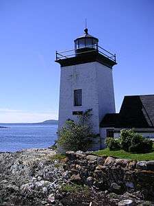
Grindel Point Light (also spelled Grindle Point Light) is a lighthouse in Islesboro, Maine, marking the west entrance to Gilkey Harbor at the westernmost point of the eponymous island. The light station was established in 1850, and the present tower and keeper's house were built in 1874. The station was deactivated in 1934 and reactivated in 1987. It was listed on the National Register of Historic Places in 1987.[3] The keeper's house now houses the Grindle Point Sailor's Museum and the lighthouse tower is open for tours in the summer.
Description and history
The town of Islesboro occupies an eponymous island in Penobscot Bay, on the central Maine coast. The island is roughly shaped as two lobes joined by a narrow isthmus. The westernmost point of the island, called Grindel's (or "Grindle's") Point, is located at the southern tip of a peninsula extending southwest from the southern lobe. The light stands to the west of Ferry Road, near the wharf serving the ferry connecting Islesboro to the mainland at Lincolnville. The lighthouse is a short tapered square brick structure, topped by a lantern house surrounded by a metal deck with rounded railing. A covered passageway, slightly below ground level, connects the tower to the keeper's house, a rectangular wood frame structure with a gable roof. Just northwest of the house stands a wooden boathouse, and a small brick oilhouse stands further north.[4]
The light station was authorized by the United States Navy in 1849, and the first tower and keeper's house were completed the following year. These brick structures were deemed beyond repair in 1874, and the present station was built on the foundations of the old one. The title name is the official USCG name[2] and is derived from the name of the second lightkeeper, Francis Grindle.[5] The USCG History site calls it "Grindle Point".[1] The United States Coast Guard planned to automate the light as early as 1923. After public resistance delayed this, the Coast Guard in 1934 mounted a new light on a steel tower nearby in 1934.[4] The town of Islesboro bought the light for $1,200 and established the Sailors' Memorial Museum there. After considerable public pressure, the Coast Guard reestablished the light in 1987.
See also
| Wikimedia Commons has media related to Grindel Point Light. |
References
- 1 2 "Historic Light Station Information and Photography: Maine". United States Coast Guard Historian's Office. 2009-08-06.
- 1 2 United States Coast Guard (2009). Light List, Volume I, Atlantic Coast, St. Croix River, Maine to Shrewsbury River, New Jersey. p. 39.
- 1 2 National Park Service (2009-03-13). "National Register Information System". National Register of Historic Places. National Park Service.
- 1 2 "NRHP nomination for Grindle Point Light Station" (PDF). National Park Service. Retrieved 2015-10-11.
- ↑ "Maine Tourism: Grindle Point Lighthouse". ALLTrips Travel Guides. 2009-08-13.
External links

| Topics | |
|---|---|
| Lists by states |
|
| Lists by insular areas | |
| Lists by associated states | |
| Other areas | |
| |