Greta, New South Wales
| Greta Cessnock, New South Wales | |||||||||||||
|---|---|---|---|---|---|---|---|---|---|---|---|---|---|
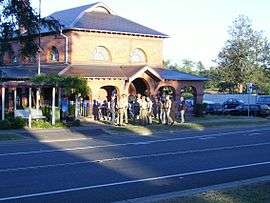 Greta's historic court house | |||||||||||||
|
Greta | |||||||||||||
| Coordinates | 32°41′14″S 151°23′4″E / 32.68722°S 151.38444°ECoordinates: 32°41′14″S 151°23′4″E / 32.68722°S 151.38444°E | ||||||||||||
| Population | 2,483 (2011 census)[1][Note 1] | ||||||||||||
| • Density | 486.9/km2 (1,261/sq mi) [Note 2] | ||||||||||||
| Postcode(s) | 2334 | ||||||||||||
| Elevation | 70 m (230 ft)[Note 3] | ||||||||||||
| Area | 5.1 km2 (2.0 sq mi)[2][Note 4] | ||||||||||||
| Time zone | AEST (UTC+10) | ||||||||||||
| • Summer (DST) | AEDT (UTC+11) | ||||||||||||
| Location | |||||||||||||
| LGA(s) | |||||||||||||
| Region | Hunter[3][4] | ||||||||||||
| County | Northumberland[5] | ||||||||||||
| Parish | Branxton[5] | ||||||||||||
| State electorate(s) | Cessnock[6] | ||||||||||||
| Federal Division(s) | Hunter[7] | ||||||||||||
| |||||||||||||
Greta is a suburb of the Cessnock and Maitland local government areas in the Hunter Region of New South Wales, Australia.[3][4][8] Most of the population lives in the town of the same name, located in the north of the suburb, which is bisected by the New England Highway.[8][9] At the 2011 census the town had a population of 2,483.[1] It is largely a commuter town located midway between Cessnock, Singleton and Maitland. The town is linked to nearby Branxton especially during community events. Greta is close to major grape-growing areas of the Hunter Region.
Greta Army Camp
The Greta Army Camp, located on the town's outskirts, was opened in 1939 as a training ground for World War II soldier training, and in 1949 was transferred to the Department of Immigration who transformed it into one of Australia's largest migrant reception and training centres between June 1949 and January 1960 as part of the post-war immigration to Australia. Over 100,000 new migrants seeking a new life in Australia passed through Greta Camp throughout its 11-years in operation.[10]
Sport
Greta is heavily associated with Branxton, which is only 3.6 km (2.2 mi) to the northwest, with many combined sporting ventures, the most notable being "The Greta-Branxton Wildcats" soccer and "Greta-Branxton Colts" rugby league clubs.
Tidy Towns
Greta's Tidy Towns projects have also been nationally recognised and even achieved multiple awards and prestige for its beautification of what was once considered an unfashionable place to live. Greta Tidy Towns Committee meets regularly to discuss changes to the town and to manage its continuing beautification.
Transport
Greta is located on the New England Highway, approximately 183 km (114 mi) north of Sydney. Access to Sydney will be possible via the Hunter Expressway when it is completed. NSW TrainLink's Hunter Line passes through Greta railway station, which opened in 1869.[11]
Images of Greta
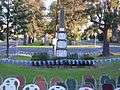 Greta War Memorial Cenotaph
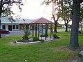 Greta Rest area shelter
 The welcoming sign to Greta's Hunter River Catchment
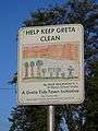 A Child's litter prevention sign. These signs were commissioned by Greta Tidy Towns to help children understand the importance of maintaining a Tidy Town
Notes
- ↑ ABS QuickStats only provides population data for the town of Greta, not the entire suburb.
- ↑ This is the average density of the actual town, based on figures provided by the ABS.
- ↑ Average elevation of the suburb as shown on 1:100000 map 9132 Cessnock.
- ↑ This is the area of the town, not the entire suburb.
References
- 1 2 Australian Bureau of Statistics (31 October 2012). "Greta (NSW) (State Suburb)". 2011 Census QuickStats. Retrieved 25 September 2012.
- ↑ Australian Bureau of Statistics (31 October 2012). "2011 Community Profiles: Greta (NSW) (State Suburb)". 2011 Census of Population and Housing. Retrieved 25 September 2012.
- 1 2 3 "Suburb Search – Local Council Boundaries – Hunter (HT) – Cessnock City Council". New South Wales Division of Local Government. Retrieved 25 September 2012.
- 1 2 3 "Suburb Search – Local Council Boundaries – Hunter (HT) – Maitland City Council". New South Wales Division of Local Government. Retrieved 25 September 2012.
- 1 2 "Greta (suburb)". Geographical Names Register (GNR) of NSW. Geographical Names Board of New South Wales. Retrieved 25 September 2012.
- ↑ "Cessnock". New South Wales Electoral Commission. 24 September 2012. Retrieved 25 September 2012.
- ↑ "Hunter". Australian Electoral Commission. 26 July 2012. Retrieved 25 September 2012.
- 1 2 "Greta". Land and Property Management Authority - Spatial Information eXchange. New South Wales Land and Property Information. Retrieved 25 September 2012.
- ↑ "Greta (town)". Geographical Names Register (GNR) of NSW. Geographical Names Board of New South Wales. Retrieved 25 September 2012.
- ↑ Newcastle City Council. "New Lives, New Australians – Snapshots of Greta Migrant Camp, 1949 – 1960". Local Government & Shires Associations of NSW. Retrieved 25 September 2012.
- ↑ "Main North Line". NSWrail.net. Retrieved 25 September 2012.
External links
| Wikimedia Commons has media related to Greta, New South Wales. |
- "Greta". Australian Explorer. Retrieved 25 September 2012.