Gregory County, South Dakota
| Gregory County, South Dakota | |
|---|---|
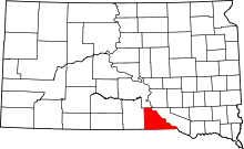 Location in the U.S. state of South Dakota | |
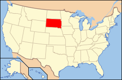 South Dakota's location in the U.S. | |
| Founded | 1898 |
| Seat | Burke |
| Largest city | Gregory |
| Area | |
| • Total | 1,054 sq mi (2,730 km2) |
| • Land | 1,015 sq mi (2,629 km2) |
| • Water | 39 sq mi (101 km2), 3.7% |
| Population (est.) | |
| • (2015) | 4,201 |
| • Density | 4.2/sq mi (2/km²) |
| Congressional district | At-large |
| Time zone | Central: UTC-6/-5 |
Gregory County is a county located in the U.S. state of South Dakota. As of the 2010 census, the population was 4,271.[1] Its county seat is Burke.[2] The county was created in 1862 and organized in 1898.[3] It was named for the politician J. Shaw Gregory.[4]
Geography
According to the U.S. Census Bureau, the county has a total area of 1,054 square miles (2,730 km2), of which 1,015 square miles (2,630 km2) is land and 39 square miles (100 km2) (3.7%) is water.[5]
Major highways
 U.S. Highway 18
 U.S. Highway 281
 South Dakota Highway 43
 South Dakota Highway 44
 South Dakota Highway 47
 South Dakota Highway 251
 South Dakota Highway 1806
Adjacent counties
- Lyman County, South Dakota - north
- Charles Mix County, South Dakota - east
- Boyd County, Nebraska - south
- Keya Paha County, Nebraska - southwest
- Tripp County, South Dakota - west
National protected area
Demographics
| Historical population | |||
|---|---|---|---|
| Census | Pop. | %± | |
| 1890 | 295 | — | |
| 1900 | 2,211 | 649.5% | |
| 1910 | 13,061 | 490.7% | |
| 1920 | 12,700 | −2.8% | |
| 1930 | 11,420 | −10.1% | |
| 1940 | 9,554 | −16.3% | |
| 1950 | 8,556 | −10.4% | |
| 1960 | 7,399 | −13.5% | |
| 1970 | 6,710 | −9.3% | |
| 1980 | 6,015 | −10.4% | |
| 1990 | 5,359 | −10.9% | |
| 2000 | 4,792 | −10.6% | |
| 2010 | 4,271 | −10.9% | |
| Est. 2015 | 4,201 | [6] | −1.6% |
| U.S. Decennial Census[7] 1790-1960[8] 1900-1990[9] 1990-2000[10] 2010-2015[1] | |||
2000 census
As of the census[11] of 2000, there were 4,792 people, 2,022 households, and 1,290 families residing in the county. The population density was 5 people per square mile (2/km²). There were 2,405 housing units at an average density of 2 per square mile (1/km²). The racial makeup of the county was 93.18% White, 0.04% Black or African American, 5.59% Native American, 0.23% Asian, 0.10% from other races, and 0.86% from two or more races. 0.86% of the population were Hispanic or Latino of any race. 50.0% were of German, 7.9% Czech, 6.3% Irish, 5.7% American and 5.5% English ancestry.
There were 2,022 households out of which 26.40% had children under the age of 18 living with them, 55.20% were married couples living together, 5.70% had a female householder with no husband present, and 36.20% were non-families. 33.90% of all households were made up of individuals and 20.30% had someone living alone who was 65 years of age or older. The average household size was 2.32 and the average family size was 2.98.
In the county, the population was spread out with 24.30% under the age of 18, 5.10% from 18 to 24, 22.00% from 25 to 44, 23.80% from 45 to 64, and 24.80% who were 65 years of age or older. The median age was 44 years. For every 100 females there were 94.50 males. For every 100 females age 18 and over, there were 91.90 males.
The median income for a household in the county was $22,732, and the median income for a family was $30,833. Males had a median income of $21,063 versus $16,920 for females. The per capita income for the county was $13,656. About 15.10% of families and 20.10% of the population were below the poverty line, including 24.50% of those under age 18 and 20.60% of those age 65 or over.
2010 census
As of the 2010 United States Census, there were 4,271 people, 1,936 households, and 1,172 families residing in the county.[12] The population density was 4.2 inhabitants per square mile (1.6/km2). There were 2,503 housing units at an average density of 2.5 per square mile (0.97/km2).[13] The racial makeup of the county was 89.6% white, 7.5% American Indian, 0.3% Asian, 0.2% black or African American, 0.2% from other races, and 2.2% from two or more races. Those of Hispanic or Latino origin made up 0.9% of the population.[12] In terms of ancestry, 54.5% were German, 11.4% were Irish, 10.9% were Czech, 7.1% were English, 6.0% were Norwegian, and 2.4% were American.[14]
Of the 1,936 households, 23.7% had children under the age of 18 living with them, 49.9% were married couples living together, 7.4% had a female householder with no husband present, 39.5% were non-families, and 36.6% of all households were made up of individuals. The average household size was 2.18 and the average family size was 2.84. The median age was 48.2 years.[12]
The median income for a household in the county was $33,940 and the median income for a family was $44,333. Males had a median income of $30,401 versus $25,804 for females. The per capita income for the county was $21,311. About 10.7% of families and 16.0% of the population were below the poverty line, including 27.1% of those under age 18 and 19.2% of those age 65 or over.[15]
People
The majority of Gregory County residents identify with the Republican Party. Secondary education is gaining in popularity with 2 year technical school being the most popular choice. Religion is a major identifier. Although many residents are seen at bars and the local strip club.
Gregory County is not extremely tolerable of minorities or people of different religion or sexual preference. While many of the residents have not had interactions with many minorities, people of different religion, or members of the LBGT community, there is strong opposition towards those groups.
Communities
Cities
Towns
Census-designated place
Townships
The county is divided into thirteen townships:
- Burke
- Carlock
- Dickens
- Dixon
- Edens
- Ellston
- Fairfax
- Jones
- Landing Creek
- Pleasant Valley
- Star Valley
- Whetstone
Unorganized territories
The county has four areas of unorganized territory:
- East Gregory
- North Gregory
- Southeast Gregory
- Spring Valley
Economy
Farming and ranching are two main economic factors of the county. However over the past ten years a trend has been noticed where residents are not working but living with parents and being supported by parents or grandparents. This is a troubling trend as the population ages. Many of the farmers depend on subsidies to help make ends meet and pay for their kids and grandkids. The link provided by www.farm.ewg.org lists the recipients and dollar amounts.[16]
Hunting is another strong economic factor in the county and there are numerous hunting lodges and hunting guides for pheasant hunting, deer hunting, and fishing. Many people who work in this industry work during the hunting season and fill the rest of their year with recreational activities.
The county is currently seeing an increase in people moving to the county. This is creating a seller's market for real estate.
National Register of Historic Places sites
References
- 1 2 "State & County QuickFacts". United States Census Bureau. Retrieved November 25, 2013.
- ↑ "Find a County". National Association of Counties. Retrieved 2011-06-07.
- ↑ "Dakota Territory, South Dakota, and North Dakota: Individual County Chronologies". Dakota Territory Atlas of Historical County Boundaries. The Newberry Library. 2006. Retrieved March 29, 2015.
- ↑ Gannett, Henry (1905). The Origin of Certain Place Names in the United States. Govt. Print. Off. p. 144.
- ↑ "2010 Census Gazetteer Files". United States Census Bureau. August 22, 2012. Retrieved March 26, 2015.
- ↑ "County Totals Dataset: Population, Population Change and Estimated Components of Population Change: April 1, 2010 to July 1, 2015". Retrieved July 2, 2016.
- ↑ "U.S. Decennial Census". United States Census Bureau. Retrieved March 26, 2015.
- ↑ "Historical Census Browser". University of Virginia Library. Retrieved March 26, 2015.
- ↑ Forstall, Richard L., ed. (March 27, 1995). "Population of Counties by Decennial Census: 1900 to 1990". United States Census Bureau. Retrieved March 26, 2015.
- ↑ "Census 2000 PHC-T-4. Ranking Tables for Counties: 1990 and 2000" (PDF). United States Census Bureau. April 2, 2001. Retrieved March 26, 2015.
- ↑ "American FactFinder". United States Census Bureau. Retrieved 2011-05-14.
- 1 2 3 "DP-1 Profile of General Population and Housing Characteristics: 2010 Demographic Profile Data". United States Census Bureau. Retrieved 2016-03-11.
- ↑ "Population, Housing Units, Area, and Density: 2010 - County". United States Census Bureau. Retrieved 2016-03-11.
- ↑ "DP02 SELECTED SOCIAL CHARACTERISTICS IN THE UNITED STATES – 2006-2010 American Community Survey 5-Year Estimates". United States Census Bureau. Retrieved 2016-03-11.
- ↑ "DP03 SELECTED ECONOMIC CHARACTERISTICS – 2006-2010 American Community Survey 5-Year Estimates". United States Census Bureau. Retrieved 2016-03-11.
- ↑ Database, EWG's Farm Subsidy. "EWG's Farm Subsidy Database". farm.ewg.org. Retrieved 2016-11-14.
 |
Lyman County | | ||
| Tripp County | |
Charles Mix County | ||
| ||||
| | ||||
| Keya Paha County, Nebraska | Boyd County, Nebraska |
Municipalities and communities of Gregory County, South Dakota, United States | ||
|---|---|---|
| Cities | | |
| Towns | ||
| CDP | ||
| Unincorporated communities | ||
| Indian reservation | ||
| Footnotes | ‡This populated place also has portions in an adjacent county or counties | |
Coordinates: 43°12′N 99°11′W / 43.20°N 99.18°W