Greenville, Kentucky
| Greenville | ||
|---|---|---|
| City | ||
|
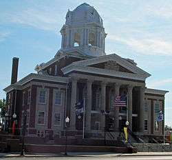
The courthouse in Greenville. | ||
| ||
 Location of Greenville within Kentucky. | ||
| Coordinates: 37°12′26″N 87°10′35″W / 37.20722°N 87.17639°WCoordinates: 37°12′26″N 87°10′35″W / 37.20722°N 87.17639°W | ||
| Country | United States | |
| State | Kentucky | |
| County | Muhlenberg | |
| Settled | 1812 | |
| Incorporated | 1848 | |
| Named for |
Maj. Gen. Nathanael Greene or nearby forests | |
| Government | ||
| • Mayor | Jan Yonts | |
| Area | ||
| • Total | 4.8 sq mi (12.4 km2) | |
| • Land | 4.8 sq mi (12.4 km2) | |
| • Water | 0.0 sq mi (0.0 km2) | |
| Elevation | 525 ft (160 m) | |
| Population (2010) | ||
| • Total | 4,312 | |
| Time zone | CST (UTC-6) | |
| • Summer (DST) | CDT (UTC-5) | |
| ZIP Code | 42345 | |
| Area code(s) | 270 & 364 | |
| FIPS code | 21-33022 | |
| GNIS feature ID | 0493344 | |

Greenville is a city in Muhlenberg County, Kentucky, in the United States. It is the seat of its county.[1] The population was 4,312 at the 2010 census.
History
The town was settled in 1799 on an estate donated by local landowner William Campbell in order to establish a seat of government for a new county. Greenville was not established by the state assembly until 1812, however.[2] It was incorporated as a city in 1848.[3]
The city was probably named for the Revolutionary War general Nathanael Greene.[4] Local lore holds it was named by Campbell's wife after the abundant forests seen from the town's hilltop location.[2]
Geography
Greenville is located at 37°12′26″N 87°10′35″W / 37.20722°N 87.17639°W (37.207158, -87.176499).[5]
According to the United States Census Bureau, the city has a total area of 4.8 square miles (12 km2), of which 4.8 square miles (12 km2) is land and 0.21% is water.
Demographics
| Historical population | |||
|---|---|---|---|
| Census | Pop. | %± | |
| 1830 | 217 | — | |
| 1870 | 557 | — | |
| 1880 | 866 | 55.5% | |
| 1890 | 968 | 11.8% | |
| 1900 | 1,051 | 8.6% | |
| 1910 | 1,604 | 52.6% | |
| 1920 | 1,917 | 19.5% | |
| 1930 | 2,451 | 27.9% | |
| 1940 | 2,347 | −4.2% | |
| 1950 | 2,661 | 13.4% | |
| 1960 | 3,198 | 20.2% | |
| 1970 | 3,875 | 21.2% | |
| 1980 | 4,631 | 19.5% | |
| 1990 | 4,689 | 1.3% | |
| 2000 | 4,398 | −6.2% | |
| 2010 | 4,312 | −2.0% | |
| Est. 2015 | 4,395 | [6] | 1.9% |
As of the census[8] of 2000, there were 4,398 people, 1,859 households, and 1,217 families residing in the city. The population density was 921.7 people per square mile (356.0/km²). There were 2,047 housing units at an average density of 429.0 per square mile (165.7/km²). The racial makeup of the city was 89.88% White, 8.75% African American, 0.16% Native American, 0.09% Asian, 0.11% from other races, and 1.00% from two or more races. Hispanics or Latinos of any race were 0.30% of the population.
There were 1,859 households out of which 25.4% had children under the age of 18 living with them, 49.8% were married couples living together, 12.9% had a female householder with no husband present, and 34.5% were non-families. 32.7% of all households were made up of individuals and 18.2% had someone living alone who was 65 years of age or older. The average household size was 2.19 and the average family size was 2.75.
The age distribution was 19.1% under the age of 18, 7.6% from 18 to 24, 23.7% from 25 to 44, 25.2% from 45 to 64, and 24.4% who were 65 years of age or older. The median age was 45 years. For every 100 females there were 77.7 males. For every 100 females age 18 and over, there were 73.9 males.
The median income for a household in the city was $25,521, and the median income for a family was $35,571. Males had a median income of $37,454 versus $18,375 for females. The per capita income for the city was $19,708. About 14.2% of families and 19.0% of the population were below the poverty line, including 24.1% of those under age 18 and 15.4% of those age 65 or over.
Economy
The 1987 Encyclopedia of Kentucky refers to Greenville as "the unofficial capital of the Black Belt", a reference to the area's production of coal and dark tobacco.[9]
Sites of interest
Veterans Plaza
The Muhlenberg County Veterans Mall and Plaza was originally constructed in the mid 1980s as the "Muhlenberg County War Memorial" to honor veterans who fought in World War I, World War II, the Korean War and the Vietnam War. The construction of the current plaza began in the mid 2000s as a part of the Muhlenberg County Courthouse renovations. New additions to the memorial include the Lt. Ephraim McLean Brank Memorial, located at the entrance of the plaza and the Historic Gristmill Stone which is a tribute to the song "Paradise" by John Prine.[10][11]
Thistle Cottage

Thistle Cottage, formerly the Duncan Cultural Center, occupies the former home of William Graham Duncan on Cherry Street in Greenville. Constructed in 1912, the home was donated to the city of Greenville by Hamilton Richardson Duncan, Sr., the last of the Duncan family to reside there, in 1986. It became the Duncan Cultural Center a year later but did not open to the public until 1989. The house became a part of Muhlenberg County Public Libraries in 2013, at which time the name reverted to Thistle Cottage, as the home was originally christened by builder William G. Duncan.[12]
Today, the Center displays a number of artifacts related to the history and culture of Muhlenberg County, including a coal museum. It is also available for rent to host parties and other special events.
Muhlenberg County Rail Trail
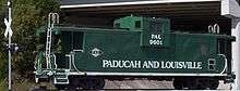
The Muhlenberg County Rail Trail is a paved trail following an old Paducah and Louisville railway route between Central City, Kentucky and Greenville that is open to pedestrian and non-motorized vehicle traffic. Kentucky's most extensive rail trail conversion to date, the Muhlenberg Rail Trail opened October 20, 2000 and was named "Trail of the Month" by the Rails to Trails Conservancy in May 2004.[13] A viewing platform and birding guide are available where the trail passes through a local wetland.[14] The Muhlenberg County Rails to Trails Committee has railbanked an additional 3 miles (4.8 km) of abandoned rail, possibly for a later extension into McLean County.[15]
Annual events
- Saturday's on the Square, a free summer concert series in downtown Greenville
- Squash & Gobble, an arts bazaar and fall festival in downtown Greenville.
- The "Clodhopper" Vintage Tractor Show in downtown Greenville.
Notable people
- Alney McLean was a United States Representative from Kentucky.
- Edward Rumsey was a United States Representative from Kentucky.
- Vernard Eugene Bivin was a recipient of the Navy Cross and was the namesake of the destroyer escort USS Bivin (DE-536)
- Actor Miles Heizer is an actor.
- Musician Jim Walker is a flautist.
- Ephraim McLean Brank, soldier and lawyer
- Danny Morris, baseball player
- Jonathan E. Spilman, composer, attorney and minister
See also
- Other places named Greenville
References
- ↑ "Find a County". National Association of Counties. Retrieved 2011-06-07.
- 1 2 Rennick, Robert M. (1987). Kentucky Place Names. University Press of Kentucky. p. 126. Retrieved 28 Apr 2013.
- ↑ Commonwealth of Kentucky. Office of the Secretary of State. Land Office. "Greenville, Kentucky". Accessed 28 Jul 2013.
- ↑ "History of Greenville, Muhlenberg County, Kentucky".
- ↑ "US Gazetteer files: 2010, 2000, and 1990". United States Census Bureau. 2011-02-12. Retrieved 2011-04-23.
- ↑ "Annual Estimates of the Resident Population for Incorporated Places: April 1, 2010 to July 1, 2015". Retrieved July 2, 2016.
- ↑ "Census of Population and Housing". Census.gov. Retrieved June 4, 2015.
- ↑ "American FactFinder". United States Census Bureau. Retrieved 2008-01-31.
- ↑ "Dictionary of Places: Greenville". Encyclopedia of Kentucky. New York, New York: Somerset Publishers. 1987. ISBN 0-403-09981-1.
- ↑
- ↑
- ↑
- ↑ Trail of the Month - Muhlenberg County Rail Trail
- ↑ Rails to Trails Conservancy - Muhlenberg County Rail Trail
- ↑ Kentucky Rails to Trails Council - Muhlenberg County Rail Trail
External links
Municipalities and communities of Muhlenberg County, Kentucky, United States | ||
|---|---|---|
| Cities | 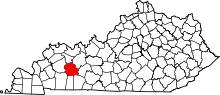 | |
| CDPs | ||
| Unincorporated communities | ||
| Ghost town | ||
| Footnotes | ‡This populated place also has portions in an adjacent county or counties | |