Greenup, Kentucky
| Greenup, Kentucky | |
|---|---|
| City | |
|
Greenup County Courthouse in Greenup | |
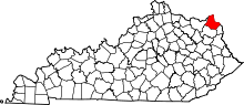
 Location of Greenup, Kentucky | |
| Coordinates: 38°34′25″N 82°50′1″W / 38.57361°N 82.83361°WCoordinates: 38°34′25″N 82°50′1″W / 38.57361°N 82.83361°W | |
| Country | United States |
| State | Kentucky |
| County | Greenup |
| Established | February 4, 1818 |
| Incorporated | February 29, 1848 |
| Named for | its county |
| Government | |
| • Type | Mayor-Council |
| • Mayor | Lundie Meadows |
| Area | |
| • Total | 1.2 sq mi (3.1 km2) |
| • Land | 0.8 sq mi (2.0 km2) |
| • Water | 0.4 sq mi (1.1 km2) |
| Elevation | 525 ft (160 m) |
| Population (2000) | |
| • Total | 1,198 |
| • Density | 1,523.0/sq mi (588.0/km2) |
| Time zone | Eastern (EST) (UTC-5) |
| • Summer (DST) | EDT (UTC-4) |
| ZIP code | 41144 |
| Area code(s) | 606 |
| FIPS code | 21-33004 |
| GNIS feature ID | 0493340 |

Greenup is a home rule-class city[1] located at the confluence of the Little Sandy River with the Ohio River in Greenup County, Kentucky, in the United States. The population was 1,198 at the 2000 U.S. census. Greenup is one of three county seats in the Commonwealth of Kentucky to share its name with its county; the other two being Harlan and Henderson.[2]
Greenup is a part of the Huntington-Ashland, WV-KY-OH Metropolitan Statistical Area (MSA). As of the 2000 census, the MSA had a population of 288,649.
History
Greenup was laid out from 1803–1804 by Robert Johnson, a pioneer and legislator who owned the land. Upon the formation of Greenup County (named for the former representative and future governor Christopher Greenup) out of land separated from Mason, Johnson's settlement was chosen to be the seat of government and adopted the name Greenupsburg. Its post office was erected on July 1, 1811.[3] The state assembly formally established the town on February 4, 1818, and incorporated the city thirty years later on February 29, 1848. The name was shortened to Greenup on March 13, 1872, partially to avoid confusion with Greensburg.[4]
The Ohio River Flood of 1937 brought devastation to Greenup.[5]
Geography
Greenup is located at 38°34′25″N 82°50′1″W / 38.57361°N 82.83361°W (38.573503, -82.833549).[6]
According to the United States Census Bureau, the city has a total area of 1.2 square miles (3.1 km2), of which 0.8 square miles (2.1 km2) is land and 0.4 square miles (1.0 km2) (34.17%) is water.
Government
The city of Greenup is governed by a mayor-council form of government. The city's current mayor is Lundie Meadows. Its representative body is the city council, which consists of a panel of six individuals.
Public safety
Greenup is protected by its own police and fire departments. In addition, surrounding fire and police departments are in a mutual aid agreement with the city of Greenup. Also, the Greenup County Sheriff's Department offices are located in the Greenup County Courthouse in Downtown Greenup. Emergency medical service is provided by Greenup County Emergency Medical Services.
- Greenup Fire Department (Station 70) is located at 1110 Walnut Street.
- Greenup Police Department is located in the city's municipal building located at 1005 Walnut Street.
- Greenup County Emergency Medical Service operates a station on U.S. 23 in Greenup.
Demographics
| Historical population | |||
|---|---|---|---|
| Census | Pop. | %± | |
| 1870 | 507 | — | |
| 1880 | 833 | 64.3% | |
| 1890 | 669 | −19.7% | |
| 1900 | 711 | 6.3% | |
| 1910 | 680 | −4.4% | |
| 1920 | 910 | 33.8% | |
| 1930 | 1,125 | 23.6% | |
| 1940 | 1,063 | −5.5% | |
| 1950 | 1,276 | 20.0% | |
| 1960 | 1,240 | −2.8% | |
| 1970 | 1,284 | 3.5% | |
| 1980 | 1,386 | 7.9% | |
| 1990 | 1,158 | −16.5% | |
| 2000 | 1,198 | 3.5% | |
| 2010 | 1,188 | −0.8% | |
| Est. 2015 | 1,157 | [7] | −2.6% |
As of the census[9] of 2000, there were 1,198 people, 478 households, and 321 families residing in the city. The population density was 1,523.0 people per square mile (585.5/km²). There were 526 housing units at an average density of 668.7 per square mile (257.1/km²). The racial makeup of the city was 90.07% White, 8.85% African American, 0.25% Native American, 0.17% Asian, 0.17% from other races, and 0.50% from two or more races. Hispanic or Latino of any race were 0.75% of the population.
There were 478 households out of which 24.3% had children under the age of 18 living with them, 54.0% were married couples living together, 11.7% had a female householder with no husband present, and 32.8% were non-families. 31.0% of all households were made up of individuals and 17.2% had someone living alone who was 65 years of age or older. The average household size was 2.27 and the average family size was 2.83.
In the city the population was spread out with 18.5% under the age of 18, 10.2% from 18 to 24, 30.1% from 25 to 44, 22.8% from 45 to 64, and 18.4% who were 65 years of age or older. The median age was 39 years. For every 100 females there were 96.4 males. For every 100 females age 18 and over, there were 94.0 males.
The median income for a household in the city was $33,158, and the median income for a family was $41,548. Males had a median income of $33,750 versus $23,036 for females. The per capita income for the city was $15,926. About 6.2% of families and 10.7% of the population were below the poverty line, including 10.7% of those under age 18 and 12.1% of those age 65 or over.
See also
References
- ↑ "Summary and Reference Guide to House Bill 331 City Classification Reform" (PDF). Kentucky League of Cities. Retrieved December 30, 2014.
- ↑ "Find a County". National Association of Counties. Retrieved 2011-06-07.
- ↑ Rennick, Robert M. (1988). "Place Names". Kentucky Place Names. Lexington: The University Press of Kentucky. ISBN 0-8131-0179-4. Accessed 17 Apr 2009.
- ↑ Commonwealth of Kentucky. Office of the Secretary of State. Land Office. "Greenup, Kentucky". Accessed 28 Jul 2013.
- ↑ Federal Writers' Project (1996). The WPA Guide to Kentucky. University Press of Kentucky. p. 234. Retrieved 24 November 2013.
- ↑ "US Gazetteer files: 2010, 2000, and 1990". United States Census Bureau. 2011-02-12. Retrieved 2011-04-23.
- ↑ "Annual Estimates of the Resident Population for Incorporated Places: April 1, 2010 to July 1, 2015". Retrieved July 2, 2016.
- ↑ "Census of Population and Housing". Census.gov. Retrieved June 4, 2015.
- ↑ "American FactFinder". United States Census Bureau. Retrieved 2008-01-31.