Greensborough, Victoria
| Greensborough Melbourne, Victoria | |||||||||||||
|---|---|---|---|---|---|---|---|---|---|---|---|---|---|
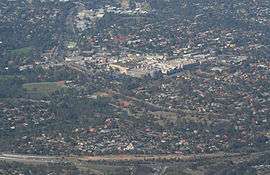 Aerial view from the north, Greensborough Bypass just in foreground, Greensborough Plaza in centre of image, and Greensborough railway station to left. | |||||||||||||
 Greensborough | |||||||||||||
| Coordinates | 37°41′10″S 145°07′01″E / 37.686°S 145.117°ECoordinates: 37°41′10″S 145°07′01″E / 37.686°S 145.117°E | ||||||||||||
| Population | 20,552 (2011 census)[1] | ||||||||||||
| • Density | 1,819/km2 (4,711/sq mi) | ||||||||||||
| Postcode(s) | 3088 | ||||||||||||
| Area | 11.3 km2 (4.4 sq mi) | ||||||||||||
| Location | 19 km (12 mi) from Melbourne CBD | ||||||||||||
| LGA(s) | |||||||||||||
| State electorate(s) | |||||||||||||
| Federal Division(s) | |||||||||||||
| |||||||||||||
Greensborough is a suburb of Melbourne, Victoria, Australia, 19 km north-east from Melbourne's Central Business District.[2] Its local government areas are the City of Banyule and the Shire of Nillumbik. At the 2011 Census, Greensborough had a population of 20,552.
The suburb was named after settler Edward Bernard Green, who was also the district mail contractor.[3] Formerly it was known as Keelbundoora, Aboriginal for "a round swamp".[4]
History
The township was established in the late 1850s, with the Post Office opening on 17 July 1858.[5]
Geography
Greensborough borders the beginning of the Green Wedge, an area of bush land left running out northward into Eltham and Diamond Creek. The Plenty River, a tributary of the Yarra River, runs through Greensborough, joining the Yarra at Templestowe.
Greensborough Plaza
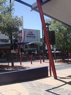
One of the major buildings in Greensborough is the [Lend Lease] owned Greensborough Plaza. Greensborough Plaza is a large shopping centre commonly regarded as one of the major shopping centres in Melbourne's north-east. It was built in 1976 and has since had many major renovations which have changed it from a small, basic shopping centre for local residents into a massive multi-level facility catering to many of the north-east suburbs.
The Plaza is not the only shopping option. The town centre contains many shops along Main Street. These days Main Street is a busy bustling street with many shops of different varieties.
In 2009, the Greensborough Town Centre was set to receive a major upgrade to bring back life into the Greensborough Town Centre. Much of it did not go ahead. A new aquatic centre, Watermarc, was built along with a multi level car park. Future development of the area is planned.
Transport
Greensborough and the suburb is serviced by a network of roads including the Greensborough Highway, which bypasses it. The main street is Main Street which runs into Diamond Creek Road, while other main arterials are Para Road which runs south and Grimshaw Street which runs west.
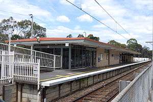
Greensborough railway station is the main passenger train station and is on the Hurstbridge railway line. After Greensborough it becomes a single line, making it a major commuter hub on that line.
Education
Greensborough College is a school in Greensborough which is home to over 1000 students and teachers, located between Greensborough and Watsonia. Greensborough is also home to several primary schools including Greensborough Primary School, established in 1878, St Mary's Catholic Primary School, St Thomas the Apostle Catholic Primary School, Greenhills Primary School, Watsonia Heights Primary School and Apollo Parkways Primary School.
Sport and recreation
Greensborough has a football team playing in the Northern Football League.
Greensborough has a polyurethane athletic track at Willinda Park, which is the home of the Diamond Valley Little Athletics Centre, the largest Little Athletics Centre in Victoria with over 750 athletes, the Diamond Valley Athletic Club and the Ivanhoe Harriers.
The DVE Aquatic Club operates out of Watermarc, a new state-of-the-art aquatic and leisure centre.
See also
- Shire of Diamond Valley - the former local government area of which Greensborough was a part
References
- ↑ Australian Bureau of Statistics (31 October 2012). "Greensborough (State Suburb)". 2011 Census QuickStats. Retrieved 1 July 2012.
- ↑ http://www.postcodes-australia.com/areas/vic/preston/greensborough
- ↑ "Prahran Mechanics' Institute – Greensborough, Victoria, Australia � History". pmi.net.au. Retrieved 20 May 2008. replacement character in
|title=at position 67 (help) - ↑ "Darebin Parklands – History". dcmc.org.au. Retrieved 20 May 2008.
- ↑ Premier Postal History. "Post Office List". Retrieved 11 April 2008.