Greenleaf, Wisconsin
| Greenleaf, Wisconsin | |
|---|---|
| Census-designated place | |
|
| |
 Location in Brown County and the state of Wisconsin. | |
| Coordinates: 44°18′48″N 88°05′46″W / 44.31333°N 88.09611°WCoordinates: 44°18′48″N 88°05′46″W / 44.31333°N 88.09611°W | |
| Country | United States |
| State | Wisconsin |
| County | Brown |
| Town | Wrightstown |
| Area[1] | |
| • Total | 1.042 sq mi (2.70 km2) |
| • Land | 1.042 sq mi (2.70 km2) |
| • Water | 0 sq mi (0 km2) |
| Elevation | 712 ft (217 m) |
| Population (2010)[2] | |
| • Total | 607 |
| • Density | 580/sq mi (220/km2) |
| Time zone | Central (CST) (UTC-6) |
| • Summer (DST) | CDT (UTC-5) |
| Area code(s) | 920 |
| GNIS feature ID | 1565848[3] |

Greenleaf is an unincorporated census-designated place in Brown County, Wisconsin, United States, in the town of Wrightstown.[3] As of the 2010 census it had a population of 607.[4]
Geography
It is located at the intersection of Wisconsin Highways 57/32 and 96.[5] It uses ZIP code 54126.[6] Greenleaf has an area of 1.042 square miles (2.70 km2), all of it land. The community is part of the Green Bay Metropolitan Statistical Area.
References
- ↑ "US Gazetteer files: 2010, 2000, and 1990". United States Census Bureau. 2011-02-12. Retrieved 2011-04-23.
- ↑ "American FactFinder". United States Census Bureau. Retrieved 2011-05-14.
- 1 2 "Greenleaf, Wisconsin". Geographic Names Information System. United States Geological Survey.
- ↑ "Geographic Identifiers: 2010 Demographic Profile Data (G001): Greenleaf CDP, Wisconsin". U.S. Census Bureau, American Factfinder. Retrieved May 13, 2014.
- ↑ "Greenleaf, Wisconsin". Google Maps. Retrieved 2009-09-19.
- ↑ United States Postal Service (2012). "USPS - Look Up a ZIP Code". Retrieved 2012-02-15.
Images
-

Looking north at the intersection of Wisconsin Highways 57/32 and 96 in Greenleaf
-

The sign for Greenleaf
-

Post office
-

Looking east at Greenleaf along WIS 96
-

Fire department
Municipalities and communities of Brown County, Wisconsin, United States | ||
|---|---|---|
| Cities | 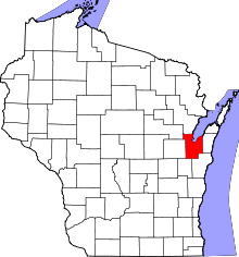 | |
| Villages | ||
| Towns | ||
| CDPs | ||
| Unincorporated communities |
| |
| Indian reservation | ||
| Ghost towns/ neighborhoods | ||
| Footnotes | ‡This populated place also has portions in an adjacent county or counties | |
This article is issued from Wikipedia - version of the 11/8/2016. The text is available under the Creative Commons Attribution/Share Alike but additional terms may apply for the media files.