Green Township, Noble County, Indiana
| Green Township | |
|---|---|
| Township | |
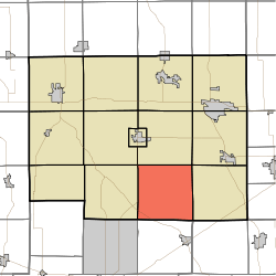 Location in Noble County | |
| Coordinates: 41°18′54″N 85°22′31″W / 41.31500°N 85.37528°WCoordinates: 41°18′54″N 85°22′31″W / 41.31500°N 85.37528°W | |
| Country |
|
| State |
|
| County | Noble |
| Government | |
| • Type | Indiana township |
| Area | |
| • Total | 36.03 sq mi (93.3 km2) |
| • Land | 35.67 sq mi (92.4 km2) |
| • Water | 0.37 sq mi (1.0 km2) 1.03% |
| Elevation | 988 ft (301 m) |
| Population (2010) | |
| • Total | 2,123 |
| • Density | 59.5/sq mi (23.0/km2) |
| ZIP codes | 46701, 46710, 46723, 46763 |
| GNIS feature ID | 0453345 |
Green Township is one of thirteen townships in Noble County, Indiana, United States. As of the 2010 census, its population was 2,123 and it contained 734 housing units.[1]
History
The Stanley School-District No. 2 was listed on the National Register of Historic Places in 2014.[2]
Geography
According to the 2010 census, the township has a total area of 36.03 square miles (93.3 km2), of which 35.67 square miles (92.4 km2) (or 99.00%) is land and 0.37 square miles (0.96 km2) (or 1.03%) is water.[1]
Unincorporated towns
- Egans Point at 41°20′09″N 85°21′38″W / 41.335882°N 85.360533°W
- Green Center at 41°18′30″N 85°21′58″W / 41.308381°N 85.366089°W
(This list is based on USGS data and may include former settlements.)
Cemeteries
The township contains Grays Cemetery.
Major highways
Airports and landing strips
- Green Center Airport
Lakes
- Bowen Lake
- Dock Lake
- Hickman Lake
- Krieger Lake
- Lindsey Lake
- Long Lake
- Mc Henry Lake
- Millers Lake
- Norman Lake
- River Lake
- Sand Lake
- Sucker Lake
- Summit Lake
School districts
- Smith-Green Community Schools
Political districts
- Indiana's 3rd congressional district
- State House District 83
- State Senate District 13
References
- "Green Township, Noble County, Indiana". Geographic Names Information System. United States Geological Survey. Retrieved 2009-10-17.
- United States Census Bureau 2008 TIGER/Line Shapefiles
- IndianaMap
- 1 2 "Population, Housing Units, Area, and Density: 2010 - County -- County Subdivision and Place -- 2010 Census Summary File 1". United States Census. Retrieved 2013-05-10.
- ↑ "National Register of Historic Places Listings". Weekly List of Actions Taken on Properties: 12/15/14 through 12/19/14. National Park Service. 2014-12-24.
External links
- Indiana Township Association
- United Township Association of Indiana
- City-Data.com page for Green Township
 |
York Township | Jefferson Township | Allen Township | |
| Noble Township | |
Swan Township | ||
| ||||
| | ||||
| Thorncreek Township, Whitley County | Smith Township, Whitley County | Eel River Township, Allen County |
Municipalities and communities of Noble County, Indiana, United States | ||
|---|---|---|
| Cities | ||
| Towns | ||
| Townships | ||
| CDP | ||
| Unincorporated communities |
| |
| Footnotes | ‡This populated place also has portions in an adjacent county or counties | |
This article is issued from Wikipedia - version of the 6/5/2016. The text is available under the Creative Commons Attribution/Share Alike but additional terms may apply for the media files.