Nottingham Urban Area

The Nottingham Built-up Area, or Nottingham Urban Area, is an area of land defined by the Office for National Statistics. It is the city of Nottingham and the adjoining urban areas of Nottinghamshire and Derbyshire, in the East Midlands of England. It had a total population of 729,977 at the time of the 2011 census.[1] An increase of almost 10% since the 2001 census recorded population of 666,358;[2] comprising population increases/reductions in 2001 areas plus the addition of the 'enclitics'; Stapleford, Sandiacre, West Hallam and Awsworth.
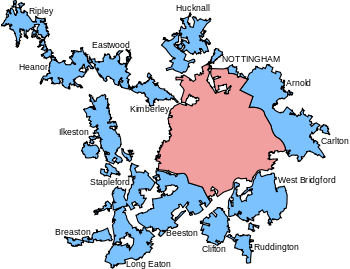
Geography
The Nottingham Urban Area is bounded to the west by a narrow gap between Breaston and Borrowash. In the 1991 census, Ilkeston was considered outside of the Nottingham Urban Area.[3] Clifton is within the current city boundaries but is considered separately for ONS purposes.
Greater Nottingham is largely within the three districts of Rushcliffe, Broxtowe and Gedling surrounding the city, though the area spills into the Nottinghamshire district of Ashfield, and also to the Amber Valley and Erewash districts of Derbyshire. The Nottingham Urban Area is, by the ONS' figures, the 8th largest in England, with a size between that of the Tyneside Built-up area and Sheffield Urban Area.
The Heanor/Ripley north-western extension has a somewhat tenuous linkage through to the core of Nottingham City and might warrant inclusion in a wider city region rather than in the Nottingham Urban Area, especially as the extension falls into Derbyshire. In the future, these towns may be associated with rather an incipient Derby Urban Area or even tend towards the rural.
| Urban Subdivision | Population | District | County | |
|---|---|---|---|---|
| 2001 census | 2011 census | |||
| Nottingham | 249,584 | 305,680 | City of Nottingham | Nottinghamshire |
| Beeston | 66,683 | 51,479 | Broxtowe | Nottinghamshire |
| Carlton | 48,493 | 49,235 | Gedling | Nottinghamshire |
| Long Eaton | 46,490 | 37,760 | Erewash | Derbyshire |
| West Bridgford | 43,395 | 45,509 | Rushcliffe | Nottinghamshire |
| Arnold | 37,402 | 37,768 | Gedling | Nottinghamshire |
| Ilkeston | 37,270 | 38,640 | Erewash | Derbyshire |
| Hucknall | 29,188 | 32,107 | Ashfield | Nottinghamshire |
| Heanor | 22,620 | 25,644 | Amber Valley | Derbyshire |
| Clifton | 22,312 | 22,407 | City of Nottingham | Nottinghamshire |
| Eastwood | 18,612 | 18,422 | Broxtowe | Nottinghamshire |
| Ripley | 18,523 | 19,315 | Amber Valley | Derbyshire |
| Stapleford | 16,190 | Broxtowe | Nottinghamshire | |
| Kimberley | 11,027 | 11,353 | Broxtowe | Nottinghamshire |
| Sandiacre | 9,600 | Erewash | Derbyshire | |
| Breaston | 7,305 | 7,545 | Erewash | Derbyshire |
| Ruddington | 6,264 | 7,020 | Rushcliffe | Nottinghamshire |
| West Hallam | 6,016 | Erewash | Derbyshire | |
| Awsworth | 2,517 | Broxtowe | Nottinghamshire | |
| Total Urban Area | 666,358 | 744,207 | ||
Notes:
- At the time of the 2001 census Awsworth and West Hallam were not part of the Nottingham Urban Area.
- At the time of the 2001 census the Beeston subdivision included Stapleford and was named Beeston and Stapleford.
- In the 2001 census Sandiacre was included as part of the Long Eaton subdivision.
Greater Nottingham Partnership
The local authorities collaborate in some ways. The Greater Nottingham Partnership considers Greater Nottingham to consist of the City of Nottingham plus the entirety of the Rushcliffe, Broxtowe and Gedling boroughs, along with Hucknall from Ashfield, but no part of Derbyshire, as no Derbyshire council is a member of the Partnership.[4]
Nottingham-Derby metropolitan area
The conurbation forms a large part of the Nottingham-Derby metropolitan area, which has an estimated population of 1.5 million.[5] The Urban Areas of both Derby and Nottingham are almost continuous with Draycott (part of the Breaston Urban sub-division) being almost continuous with Borrowash part of the Derby Urban Area.[6] The Mansfield Urban Area also forms part of this metropolitan area. This Urban Area is not continuous with the Nottingham Urban Area. However, it is almost continuous with the Alfreton Urban Area, which had a population of 41,289 according to the last census,[6] with the South Normanton/Pinxton Urban sub-division of the Alfreton Urban Area being almost continuous with the Sutton-in-Ashfield Urban sub-division of the Mansfield Urban Area. The Alfreton Urban Area is also nearly continuous with Ripley part of the Nottingham Urban Area.
See also
References
- ↑ "2011 Census – Built-up areas". ONS. Retrieved 3 July 2013.
- ↑ Office for National Statistics: Census 2001, Key Statistics for urban areas
- ↑ Statistics.gov.uk.
- ↑ Greater Nottingham Partnership Map of Greater Nottingham
- ↑ "British urban pattern: population data" (pdf). ESPON project 1.4.3 Study on Urban Functions. European Spatial Planning Observation Network. March 2007. p. 119. Retrieved 22 February 2010.
- 1 2 http://www.ons.gov.uk/ons/rel/census/census-2001-key-statistics/urban-areas-in-england-and-wales/urban-areas-in-england-and-wales-ks01-usual-resident-population.xls
External links
- Greater Nottingham partnership (GNP)
- Office for National Statistics: Census 2001, Key Statistics for urban areas
- map depicting ONS definition
- Nottingham Insight - Key datasets
| Unitary authorities | |
|---|---|
| Boroughs or districts | |
| Major settlements | |
| Topics | |
| Unitary authorities | |
|---|---|
| Boroughs or districts | |
| Major settlements |
|
| Rivers | |
| Topics | |
Coordinates: 52°58′N 1°09′W / 52.96°N 1.15°W