Great Valley Sequence
| Great Valley Sequence Stratigraphic range: Late Jurassic through Cretaceous | |
|---|---|
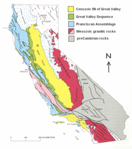 Geologic map showing location of the Great Valley Sequence. Modified from Irwin (1990)[1] | |
| Type | sedimentary |
| Underlies | Cenozoic sedimentary fill |
| Overlies | basement |
| Thickness | up to 40,000 feet (12 km)[2] |
| Lithology | |
| Primary | shale and sandstone |
| Other | minor conglomerate |
| Location | |
| Region |
Great Valley-Central Valley of California |
| Country | United States |
| Type section | |
| Named for |
Great Valley-(Central Valley) of California |
| Named by | Baily, Irwin & Jones (1964)[2] |

The Great Valley Sequence of California is a 40,000 feet (12 km)-thick group of related geologic formations that are Late Jurassic through Cretaceous in age (150–65 Ma) on the geologic time scale. These sedimentary rocks were deposited during the late Mesozoic Era in an ancient seaway that corresponds roughly to the outline of the modern Great Valley (Central Valley) of California.
Description
Although the total thickness of the Great Valley Sequence in places is upwards of 12 kilometres (39,370 ft), most of these rocks today are buried beneath the thick Cenozoic sedimentary fill of the Great Valley of California. A number of gas and oil wells do penetrate these rocks in the subsurface of the valley, and these same rocks also crop out extensively along the west margin of the valley and to a lesser extent along the northern and eastern margins. The sequence overlies the Franciscan Assemblage along the west margin of its extent, and onlaps onto granitic rocks of the Sierra Nevada in the east.[2]
The rocks in Great Valley Sequence are largely shale deposited in a deep-marine setting with thick bodies of sandstone and minor conglomerate that represent ancient deep-sea submarine fans and submarine canyons.[3] Individual sandstone beds within these fans and canyons are typically turbidites and related sediment gravity flow deposits, such as the chaotic, often coarse-grained deposits of submarine mudflows. By contrast, the shales represent clay that was originally suspended in the water column and slowly settled out on the deep ocean floor. Thus, the mudstones represent background sedimentation that took place continuously, whereas the turbidites and mudflow deposits, by and large, represent sudden events.

Depositional setting
The ancient marine basin that the Great Valley Sequence was deposited in very closely approximates the combined extent of the modern Sacramento Valley and San Joaquin Valley as delineated by the California Coast Ranges on the west side and the Sierra Nevada on the east. Geologists believe that the west boundary of this ancient seaway was made up of uplifted rocks of the Franciscan Assemblage that today make up the Coast Ranges. By contrast, the east boundary was a chain of ancient volcanoes located where the Sierra Nevada is today. As these ancient Sierran volcanoes were rapidly eroded they fed volcanic-derived sediment through submarine canyons westward to the ancient submarine fans of the Great Valley Sequence. Additional sediment was fed into the basin as the granitic roots of these volcanoes were uplifted and eroded. As a consequence, the volcanic cover of the Sierra Nevada has been largely stripped off and used by nature to fill the Great Valley basin. Little sediment is believed to have been derived from the uplifted Franciscan rocks of the Coast Ranges.[2]
Like the Franciscan, the Great Valley Sequence was deposited as a consequence of the ancient subduction of oceanic crust beneath the California continental margin prior to formation of the modern San Andreas Fault. Because a chain of volcanoes defined the east boundary, and an ancient subduction zone associated with a deep-sea oceanic trench defined the west boundary, the Great Valley represents a type of forearc basin that is also described as an arc-trench gap, or outer arc trough. Furthermore, because the Great Valley sediments are marine in origin and deposited during mountain-building events in a basin parallel to the mountains, this sequence, together with the younger marine sediments above, represent a type of sedimentary deposit that is also referred to as "flysch". As such, the Pleistocene to Recent, marginal-marine to non-marine, coaser-grained deposits that cap this succession are "molasse" deposits representing the final stage of infilling of the basin.[3][5]
Fossils
The Great Valley Sequence contains a diverse and abundant assemblage of fossils that includes microfossils, plant remains, invertebrate marine creatures, and vertebrates. The microfossils are particularly important, as unique assemblages of microfossils, especially benthic (bottom-dwelling) and planktonic (free-floating) foraminifera, that are abundant in some of the shales are used to assign ages to the rocks. Palynomorphs, which are organic-walled microfossils that include the spores and pollen of ancient plants, can be particularly useful for determining what the ancient climate was like. Another variety of palynomorphs called dinoflagellates can be as valuable for age determinations as foraminifera. Invertebrate fossils found in the Great Valley Sequence include various bivalves, gastropods, and even coiled ammonites.[6] Vertebrate fossils have been found also, mainly in the Chico and Moreno Formations in the uppermost part of the sequence, and include fish, flying reptiles (pterosaurs), and a variety of marine reptiles, including turtles, mosasaurs, plesiosaurs and ichthyosaurs.[7] There is even the recorded find at the canyon of Del Puerto Creek near Patterson in 1936 of the first dinosaur bones ever found in California, the vertebrae and hindquarters of a hadrosaur, a land-dwelling dinosaur that apparently died near the coast and was subsequently washed out to sea by a river.[8]
Formations
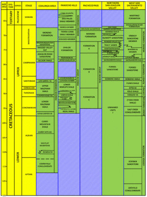
The Great Valley Sequence contains several geologic formations. Because geologists studying this sequence in different areas have used different formation names over the years to describe the same packages of rocks, the nomenclature is complex and confusing. Parts of the sequence are well exposed at several places along a line of outcrops that extends for about 150 miles (241 km) along the west side of the Sacramento and San Joaquin valleys (both of which make up the Great Valley of California). These same rocks are also found in several deep wells in oil and gas fields located in the center of the valley. Geologists working these different areas independent of each other developed different sets of formation names for the different areas. Yet refinements in dating the ages of the different units has led to the realization that an interval of rock in one area may be exactly the same age as the rocks in another area, yet be referred to by a completely different formation name.[10]
Some of the best outcrops for these rocks are on the west side of the southern Sacramento Valley at Putah Creek and Cache Creek canyons. The formation names used here extend to the subsurface where several gas wells in the center of the valley produce from the same rocks, and from younger rocks that overlie them. Although the younger rocks are not exposed in the canyons to the west, most geologists combine the formation names from the west side outcrops with the subsurface names from the gas fields to create a coherent set of names that is largely agreed upon for most of the Sacramento Valley.[11]
The same is not true for the San Joaquin Valley to the south, where another area of well-known outcrops is found in the hills to the west of Coalinga. This area uses a completely different set of formation names for exactly the same group of rocks as are found to the north. Yet another set of formation names is applied to Great Valley rocks penetrated by oil and gas wells in the subsurface northeast of Coalinga in the area near Stockton in the northern part of San Joaquin Valley. In addition, there are several lesser known areas in the San Joaquin Valley that each have their own terminologies. All of these names are firmly established in the geologic literature and attempts to set up a unified set of formation names have not met with success. An exception are the Jurassic-age rocks of the Great Valley Sequence, which most geologists assign to the Knoxville Formation, irrespective of location.[12]
Economic importance
The Sacramento Basin in the northern portion of the Great Valley is a prolific natural gas province, and most of the gas here is produced from sandstone reservoirs in the Upper Cretaceous part of the Great Valley Sequence. Virtually all of this gas is derived from organic-rich shales interbedded with the sandstone reservoirs. As such, a self-contained source-reservoir petroleum system exits. Numerous gas accumulations have been found within this system. Particularly noteworthy is the Rio Vista Gas Field, which has produced more gas than any other field in California. Many active fields continue to produce large volumes of gas from the Great Valley Sequence, and exploration for new accumulations continues.[13][14] The only oil produced from reservoirs in the Great Valley Sequence is from the Oil City pool at Coalinga Oil Field, and from two small pools at the Brentwood Oil Field to the south of Rio Vista.[15]
See also
- Franciscan Assemblage
- Natural history of the Central Valley (California)
Notes
- ↑ map is modified from figure 3.3, p. 62-63 in Irwin (1990)
- 1 2 3 4 Bailey, Irwin and Jones (1964), pp. 123–139.
- 1 2 Ingersoll and Dickinson (1977); Ingersoll and Dickinson (1990), pp. 183–215.
- ↑ diagram is modified from figure 3.11, p. 74 in Irwin (1990).
- ↑ Irwin (1990), pp. 61–82.
- ↑ Bailey, Irwin and Jones (1965), pp. 115–123.
- ↑ Hilton (2003), pp. 149–223.
- ↑ Hilton (2003), pp. 169–178.
- ↑ Based on Bartow and Nilsen (1990), Fig. 5, p. 258; Ingersoll and Dickinson (1990), Table 2, p. 197; Magoon and Valin (1996), Fig. 1, p. 8.
- ↑ Ingersoll (1990), p. 1–4 discusses the nomenclature problems of the Great Valley Sequence.
- ↑ Ingersoll and Dickinson (1990) in their Table 2 on p. 197 show the formation names used for the outcrops on the westside of the Sacramento Valley; and Magoon and Valin (1990) in their Fig. 1 show the subsurface names generally used in the Sacramento Valley gas fields.
- ↑ Bartow and Nilsen (1990) in Fig. 5 on p. 258 compare the various formation names used in the San Joaquin Valley.
- ↑ Zieglar and Spotts (1978), pp. 813–826.
- ↑ Magoon and Valin (1996), pp. 1–2.
- ↑ see "Coalinga Oil Field". In Summary of Operations, Calif. Div. of Oil & Gas, v. 31, No. 2 (1945); and
"Brentwood Oil Field". In Summary of Operations, Calif. Div. of Oil & Gas, v. 49, No. 2 (1963).
References
- Bailey, E.H., Irwin, W.P. and Jones, D.L. (1964). Franciscan and related rocks and their significance in the geology of western California. California Div. Mines and Geology Bull. 177 p.
- Bartow, J. Alan and Nilsen, Tor H. (1990). "Review of the Great Valley Sequence, eastern Diablo Range and northern San Joaquin Valley, central California". In Kuespert, J.G.; Reid, S.A. Structure, stratigraphy and hydrocarbon occurrences of the San Joaquin basin, California. Pacific of the Society of Economic Paleontologists and Mineralogists, Guidebook No. 64, p. 253–265.
- Hilton, Richard P. (2003). Dinosaurs and Other Mesozoic Reptiles of California. University of California Press. 356 p.
- Ingersoll, R.V. (1990). "Nomenclature of Upper Mesozoic strata of the Sacramento Valley of California: Review and recommendations". In Ingersoll, R.V.; Nilsen, T.H. Sacramento Valley Symposium and Guidebook. Pacific Section of the Society of Economic Paleontologists and Mineralogists. pp. 1–4.
- Ingersoll, R.V.; Dickinson, W.R. (1977). Field Guide: Great Valley Sequence, Sacramento Valley. Geological Society of America. pp. 144 p.
- Ingersoll, R.V.; Dickinson, W.R. (1990). "Great Valley Group (Sequence), Sacramento, California". In Ingersoll, R.V.; Nilsen, T.H. Sacramento Valley Symposium and Guidebook. Pacific Section of the Society of Economic Paleontologists and Mineralogists. pp. 183–215.
- Irwin, William P. (1990). "Geology and plate-tectonic development". In Robert E. Wallace. The San Andreas Fault System, California. U.S. Geological Survey Professional Paper 1515. pp. 61–82.
- Magoon, L.B.; Valin, Z.C. (1996). "Sacramento Basin Province". In Gautier, D. L.; et al. National Assessment of United States Oil and Gas Resources - Results, Methodology, and Supporting Data. United States Geological Survey, Digital Data Series DD-30, release 2. 8 p.
- Zieglar, D.L.; Spotts, J.H. (1978). "Reservoir and source-bed history of Great Valley, California". American Association of Petroleum Geologists Bulletin: v. 62, p. 813–826.
| Preceded by Proterozoic Eon | Phanerozoic Eon | |||||||||||
|---|---|---|---|---|---|---|---|---|---|---|---|---|
| Paleozoic Era | Mesozoic Era | Cenozoic Era | ||||||||||
| Cambrian | Ordovician | Silurian | Devonian | Carboniferous | Permian | Triassic | Jurassic | Cretaceous | Paleogene | Neogene | 4ry | |