Great Clarendon Street

Great Clarendon Street is one of the principal thoroughfares of the Jericho district of Oxford, England, an inner suburb northwest of the centre of the city.[1]
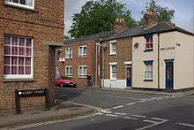
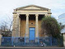
At the northeast end of the street is a junction with Walton Street.[2] Opposite is Freud's, a cafe in a historic classical former church building. To the south is the Oxford University Press, which also houses the Oxford University Press Museum. The southwest end of the street ends near the Oxford Canal, just past the junction with Canal Street.
Many of the houses here were built in the first half of the 19th century.[1] In the early 19th century, Grey Coat's (University) School was located here. The street was named in 1890–1.[3] The street is named after the Clarendon Press (aka the Oxford University Press) of Oxford University, which established itself in Jericho in 1830.
See also
- Little Clarendon Street, a nearby shopping street
References
- 1 2 Hibbert, Christopher, ed. (1988). "Great Clarendon Street". The Encyclopaedia of Oxford. Macmillan. p. 160. ISBN 0-333-39917-X.
- ↑ "Great Clarendon Street on Oxford Street Map". Oxford.StreetMapOf.co.uk. UK. Retrieved 29 December 2015.
- ↑ Symonds, Ann Spokes; Morgan, Nigel (2010). "Great Clarendon Street". The Origins of Oxford Street Names. Robert Boyd Publications. p. 116. ISBN 978 1 899536 99 3.
Coordinates: 51°45′30″N 1°16′02″W / 51.7582°N 1.2671°W