Graysontown, Virginia
| Graysontown, Virginia | |
|---|---|
| Unincorporated community | |
|
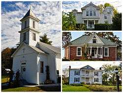
National Register of Historic Places for Graysontown Virginia. Starting clockwise, Grayson-Gravely House, Bishop House, John Grayson House, and Graysontown Methodist Church. | |
 Graysontown, Virginia  Graysontown, Virginia | |
| Coordinates: 37°02′18″N 80°33′40″W / 37.03833°N 80.56111°WCoordinates: 37°02′18″N 80°33′40″W / 37.03833°N 80.56111°W | |
| Country | United States |
| State | Virginia |
| County | Montgomery |
| Elevation | 1,854 ft (565 m) |
| Time zone | Eastern (EST) (UTC-5) |
| • Summer (DST) | EDT (UTC-4) |
| Area code(s) | 540 |
| GNIS feature ID | 1499492[1] |
Graysontown is an unincorporated community in Montgomery County, Virginia, United States. Graysontown is located on the Little River 6.5 miles (10.5 km) south of Radford.
History
Graysontown was named for John Grayson, a pioneer settler.[2]
The Bishop House, John Grayson House, Grayson-Gravely House, and Graysontown Methodist Church are listed on the National Register of Historic Places in 1989.[3]
References
- ↑ "Graysontown". Geographic Names Information System. United States Geological Survey.
- ↑ Tennis, Joe (2004). Southwest Virginia Crossroads: An Almanac of Place Names and Places to See. The Overmountain Press. p. 140. ISBN 978-1-57072-256-1.
- ↑ National Park Service (2010-07-09). "National Register Information System". National Register of Historic Places. National Park Service.
Municipalities and communities of Montgomery County, Virginia, United States | ||
|---|---|---|
| Towns |  | |
| CDPs | ||
| Unincorporated communities | ||
| Footnotes | ‡This populated place also has portions in an adjacent county or counties | |
This article is issued from Wikipedia - version of the 11/2/2016. The text is available under the Creative Commons Attribution/Share Alike but additional terms may apply for the media files.