Gray's Ferry Bridge
| Grays Ferry Avenue Bridge | |
|---|---|
 This 1999 photo looks northwest at the Philadelphia, Wilmington & Baltimore Railroad Bridge No. 1. and, behind it, the Grays Ferry Avenue Bridge. | |
| Coordinates | 39°56′28″N 75°12′18″W / 39.9411°N 75.205°WCoordinates: 39°56′28″N 75°12′18″W / 39.9411°N 75.205°W |
| Carries | Grays Ferry Avenue |
| Crosses | Schuylkill River, Northeast Corridor |
| Locale | Philadelphia, Pennsylvania |
| Owner | State Highway Agency |
| Maintained by | State Highway Agency |
| Preceded by | University Avenue Bridge |
| Followed by | Philadelphia, Wilmington and Baltimore Railroad Bridge No. 1 |
| Characteristics | |
| Design | Stringer/multi-beam or girder |
| Material | Steel continuous |
| Total length | 1,482 feet (452 m) |
| History | |
| Construction begin | 1976 |
| Opened | 1976 |
| Replaces | 1901 Grays Ferry Bridge |
| Statistics | |
| Daily traffic | 9,625 (in 2011) |
| References | |
| [1] | |
Gray's Ferry Bridge (more recently, Grays Ferry Bridge) has been the formal or informal name of several floating bridges and four permanent ones that have carried highway and rail traffic over the Schuylkill River in Philadelphia. The bridge today is a four-lane divided highway bridge, built in 1976, that carries Grays Ferry Avenue from the Grays Ferry neighborhood on the east bank over the river and the Northeast Corridor railroad tracks to the Southwest Philadelphia neighborhood of Kingsessing. An abandoned 1902 railroad bridge, the Philadelphia, Wilmington and Baltimore Railroad Bridge No. 1, sits just south of the highway bridge.
Ferry
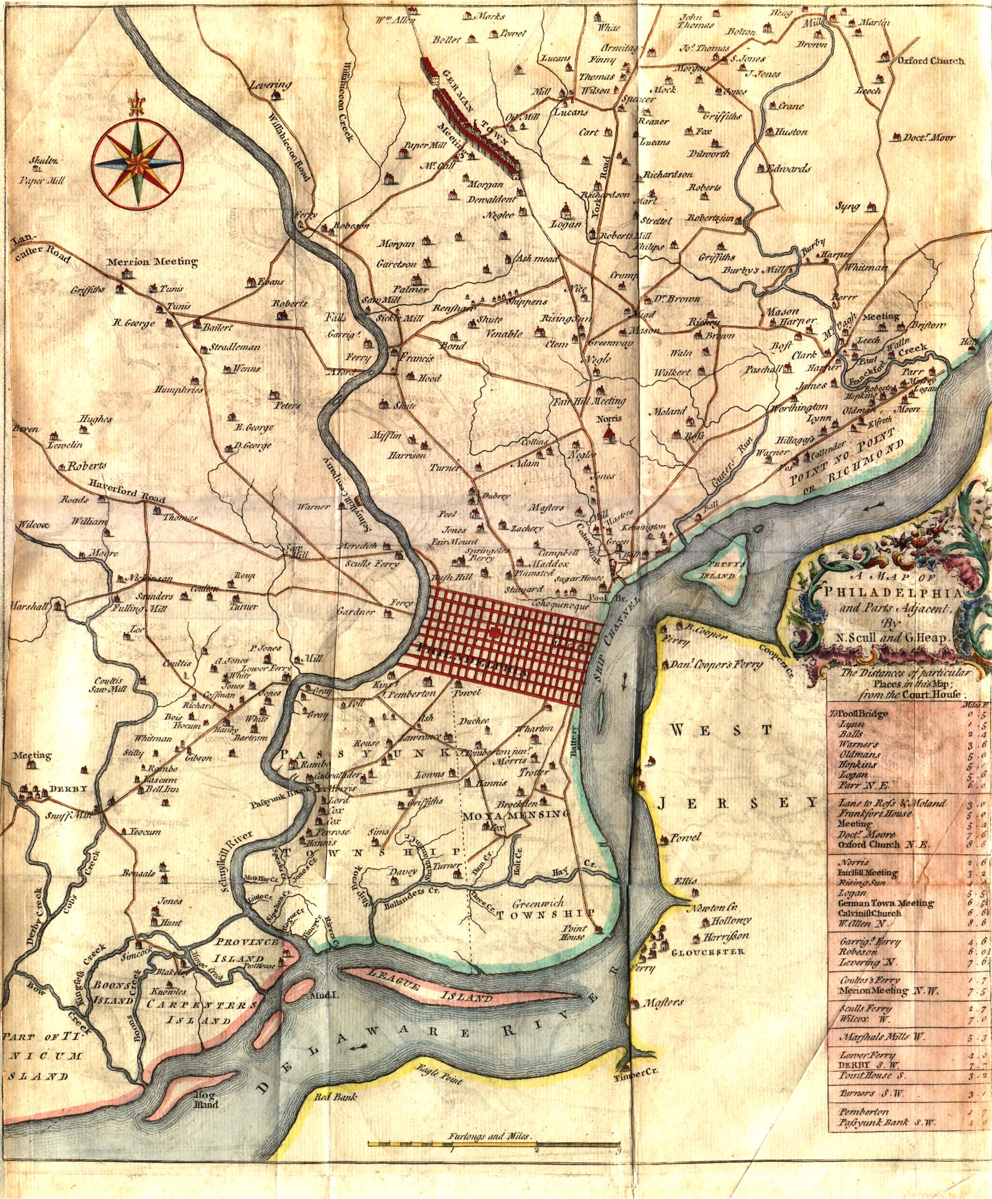
Before bridges crossed the Schuylkill, three ferries provided the main connections between Philadelphia and points west and south. Two of them crossed the river in or near the city limits:
- Upper, or Sculls, Ferry, near the present-day Spring Garden Street Bridge.
- Middle Ferry, near today's Market Street Bridge.
The third, dubbed Lower Ferry, crossed south of the city proper and just south of the mouth of Mill Creek. It was likely established in 1673 or shortly thereafter by Benjamin Chambers, who was licensed to operate the ferry after Swedish settlers complained that they were blocked from passage on the Middle Ferry.[2][3][4]
In 1696, the government directed that two roads be laid out from either end of the Lower Ferry, also called Chambers' Ferry: one from the east landing north to Philadelphia, and the other westward toward Darby, Pennsylvania.[2] The ferry thereby came to connect Philadelphia to the Darby Road (now Woodland Avenue at 47th Street), which was part of the King's Highway, the main land route to Delaware, Baltimore, and the southern colonies. It remained virtually the only conduit to the city from points south until 1781, when the construction of a federal road connected the ferry environs to Market Street in what would become West Philadelphia.[5]
It was still marked as "Lower Ferry" on a 1753 map,[6] but it would soon take the name of its new proprietors, the brothers Robert and George Gray. George (1725–1800) owned large tracts of land near the ferry's eastern landing (in today's Grays Ferry neighborhood of South Philadelphia) and in 1787 became a signatory to Pennsylvania's ratification of the U.S. Constitution.[3][7]
Floating bridges

The first bridge across the Schuylkill River was a pontoon bridge built in 1777 by British troops occupying the city. Its construction was anticipated on the American side by General John Armstrong, Sr. of the Pennsylvania militia, who wrote on October 8, "I think they will also throw a bridge of some sort over Grey's Ferry, not only to maintain a communication with but secure a retreat to their shipping."[8]
Armstrong was right. The bridge's preparation and construction were described by Captain John Montresor, the engineer on the staff of General William Howe:
- October 17, 1777 — This day principally employed in my department in transporting the materials for the Bridge of Schuylkill at Gray's Ferry together with its boats.
- 18th — The utmost preparation making to forward the Bridge at Gray's Ferry across Schuylkill.
- 20th — At half past 10 this morning the engineers finished the floating Bridge across Schuylkill of 400 feet.[8]
But this bridge remained in place only two days, as British commanders decided that the extra fording capacity was better used farther north. Montresor wrote, "22nd — At 3 o' clock p.m., the works for the tete du pont at Gray's Ferry ordered to be stopt and the Detacht. to return and the bridge to be taken up and carried to Middle Ferry." (He and his men completed this bridge on October 24, only to see it wash away four days later by "the N.E. Stormy High tide and rapid stream and Ebb tide together." A replacement floating-log bridge at Middle Ferry was passable by November 10 and completed on November 11.[8])
Back at Lower Ferry, a new floating bridge was once again in place by December 10, according to diary entries by British Army officer John André, who would go on to be the Army's chief of intelligence. On December 22, a large British force moved westward across the bridge and camped three miles from Darby. On December 28, the bridge was pulled up, perhaps to protect it from winter ice, as the Army moved north to cross back into the city at the Middle Ferry bridge.[8]
The British rebuilt the bridge at Gray's Ferry the following spring. On August 7, 1778, the Supreme Executive Council of the Commonwealth of Pennsylvania wrote to the Pennsylvania General Assembly, saying, "In the course of the war it has been found useful to lay a bridge across the Schuylkill at this city. Another bridge over that river was erected by General Washington at Providence [near Valley Forge] in this county. And a third built by the enemy [the Gray's Ferry bridge] remains entire. It is worthy of consideration how these truly convenient structures may be rendered lastingly useful. The terms on which they may be passed ought to be settled." Later that year, the deal was set: the U.S. government would pay 800 pounds annually to the State of Philadelphia to maintain the bridge.[8]
Ice smashed the bridge to pieces in 1780, leading the Council to pay Major Benjamin Eyre 7,500 pounds to rebuild it. The rebuilt bridge featured a deck over planks attached to the logs, with anchors in mid-stream to steady it and railings for safety. Flexible, it rose and fell with the tide. Heavy wagons often depressed the deck a few inches below the water. A 1796 traveler wrote, "Although this bridge floated when not charged, or charged but lightly, the weight of our waggon depressed it several inches below the surface, the horses splashing through the water so that a foot passenger passing at the same time would have been exposed to serious inconvenience." The bridge had a draw that could be lifted with ropes to allow boats to pass by. The whole span could be unmoored and allowed to float downstream in times of ice or heavy weather, then restored to service.[8][9]
The advantages of a permanent bridge were clear, but none would be built for several decades. In 1806, a "Gray's Ferry Bridge Company" was chartered, but it bore no fruit.[10]
In 1828, Martin Kochersperger noted that 304 vessels passed through the bridge in the month of March: 37 schooners, 106 sloops and shallops, 28 oyster boats, 98 curial boats, 16 fishing boats, seven pleasure boats, and 12 rafts.[11]
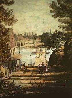
In 1834, a Philadelphia guidebook offered this description, "Gray's Ferry — renowned as the junketing place of our forefathers where our grandfathers and grandmothers danced and sung where the scenery has a right pleasant smack of the antique about it and where the floating bridge still swings as it did in the days of the revolution."[12]
Notable crossings
During the 1787 Constitutional Convention, many delegates eager to escape the hot and humid city crossed the bridge on day trips to visit Gray's Ferry Tavern or Bartram's Garden a bit farther south.[13]
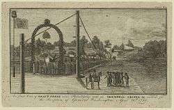
George Washington, who is likely to have used the ferry or its successor bridges whenever he traveled from his home in Mount Vernon, Virginia, to Philadelphia and points north, is known to have crossed the floating bridge at Gray's Ferry on at least two occasions. On May 13, 1787, Washington wrote about his arrival in Philadelphia for the convention to revise the Articles of Confederation: "At Grays Ferry the City light horse commanded by Colo. Miles met me, and escorted me in by the Artillery Officers who stood arranged & saluted me as I passed."[14] On April 20, 1789, when Washington traveled to New York City, then the national capital, to become the first president of the United States, the bridge was decorated for the latter occasion by the Grays, who enlisted the aid of Philadelphia artist Charles Willson Peale, with laurel arches and the flags of the states and the new country.[9]
Permanent bridges
Newkirk Viaduct (1838-1902)
In 1831, the Pennsylvania legislature chartered a new company to build a rail line from Philadelphia to the Delaware state line. A survey of routes was begun in July 1835, and the following year, company officials settled a debate over just how and where to cross the Schuylkill: a permanent bridge at Gray's Ferry. The firm, by now renamed The Philadelphia, Wilmington and Baltimore Railroad Company, bought the necessary land on December 31, 1836.[15]
Over the next two years, the railroad built an 800-foot covered truss bridge supported by five piers; its fifth span, as counted from the east, could be pulled into its sixth span to allow boats to pass. A single track ran along the bridge's southern side, separated by a fence from a roadway that ran along its northern side.[16] The cost, including construction and land acquisition, came to nearly $200,000.[17] The railroad named the bridge for its president, Matthew Newkirk (1794–1868), a Philadelphia business and civic leader, and erected an obelisk, the Newkirk Viaduct Monument, along its western approach.[18]
Construction on the rest of the 17 miles of track proceeded, and when the bridge opened in 1838, it was the final link in the first direct rail service between Philadelphia and Wilmington.[9][16] It did not initially allow locomotives to pass, nor were locomotives particularly welcomed on city streets, so the cars were pulled by horses over the river and northward along three miles of track to the terminus of the PW&B.[16] That was the Southern and Western Railroad Station, a grand six-track station and PW&B office building erected in 1840 at Broad Street and Washington Avenue (the former Prime Avenue).[19]
The new bridge was less than a year old when it was severely damaged. On January 26, 1839, historian Daniel Bowen wrote that a "great ice freshet ... swept away one of the piers and two of its sections. The floating bridge at Gray's Ferry was also carried away by the violence of the same flood. We are happy to learn that all the damages occurring from that rapid rise of the Schuylkill are in rapid progress of repair and that both the bridges are now passable." (It is not clear when the floating bridge finally ceased to exist.) The damage was repaired within weeks for less than $15,000.[20]
A toll was charged for road traffic until 1847, when Philadelphia County paid the PW&B $50,000 to eliminate the tolls. The deal also bound the railroad to rebuild the bridge if necessary.[21]
In June 1846, the Viaduct was chosen as the route for the telegraph line that completing the first telecommunications link from New York to Washington; operators complained of interruptions whenever the draw was opened.[22] In 1852, the bridge was strengthened to handle more weight, and steam power at last replaced horses.[17][23]
During the Civil War, the PW&B's Philadelphia terminal became the great embarkation and debarkation point for Philadelphia men going to and returning from war in the southern states.[24] At least one source says the bridge was destroyed by fire (except for the westernmost span) in 1863, and rebuilt as a Town Lattice truss that was left uncovered. In 1865, the bridge was cited in the 1865 U.S. Supreme Court case Gilman v. Philadelphia, which upheld the power of Congress to regulate interstate commerce, including navigable streams in a particular state.[25]


By 1889, the Newkirk Viaduct was a four-span, 503-foot bridge, including a 92-foot Howe truss span with a 144-foot cover.[26]
The several acres around the Viaduct's western end had become a hub of railroad activity. The area had had an enginehouse since the Viaduct opened;[27] by 1876, a bigger, eight-stall roundhouse had been erected. By 1877, passenger trains stopped at the Gray's Ferry station, on 49th Street between Grays and Paschall Streets.[28] Here, northbound express trains from Washington, Baltimore, or Wilmington and heading farther north would be switched from PW&B tracks to the Junction Railroad and on to the PRR's Philadelphia depot, allowing their passengers to continue their journey without switching trains.
In 1873, the route south of the bridge was shifted somewhat away from the riverbank as far as Chester, a shift that drew the tracks away from marshy ground and eliminated several drawbridges from the route.[29] The first train ran over this Darby Improvement route on May 12.[19][30]
The Viaduct's importance as a rail bridge waned after 1880-81, when the Pennsylvania Railroad took control of the PW&B. The PRR, whose passenger trains ran through West Philadelphia, used the Viaduct only to run freight to the Delaware River docks via Washington Street, while the Baltimore & Ohio, which had previously run trains over the bridge, was forced to build its own bridge one-third of a mile to the south.[2]
A new draw span was constructed in 1891, but maintenance remained difficult for the rest of the decade.[16] Moreover, the city of Philadelphia itched for a broader bridge to carry trolley and other street traffic between the rapidly developing neighborhoods of Grays Ferry and Kingsessing.
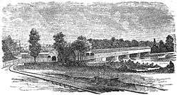
Grays Ferry Bridge (1901-76)

By the end of the 19th century, the narrow Newkirk Viaduct was a roadway bottleneck. "Much of the traffic that would naturally cross the river at Gray's Ferry has been diverted to the South Street bridge because of the congested conditions that exist from morning until night at the railroad crossing," wrote the Philadelphia Record in 1900. "The steep incline at the western end of the old bridge has always been a obstacle to heavily-laden wagons, and at times during the day the crush of teams is actually dangerous."[31] In December 1896, the city of Philadelphia appropriated $400,000 to build the new Grays Ferry Bridge (it ultimately cost about $475,000). The appropriation was authorized by ordinance the following April.[31]
The stonework was completed in December 1898 by Jutte and Foley Company of Pittsburgh for $250,000. The five river piers were excavated to bedrock, as were most of the bridge's abutments and pedestals. The masonry was "rockfaced ashlar, with coping and bridge seats of Port Deposit granite."[31]
The metal superstructure, plus a timber fender on the eastern side of the west draw channel and a cluster of wooden pilings at the north end of the west draw pier, were built by the Phoenix Bridge Company, which completed its work on March 1, 1901, under a $145,959.98 contract. The pavement, railings, and "other appurtenances" were completed May 20, by the Alcatraz Paving Company for $66,870.[32]
The bridge was 1,190 feet long, including 1,660 feet of metal superstructure, with a 36-foot-wide roadway and two 10-foot-wide sidewalks. It also held two trolley tracks belonging to the Union Traction Company, "connecting the Spruce and Pine streets division with the Darby lines on Woodland Avenue at Gray's Ferry road." The west end was far higher than the old Newkirk Viaduct, for it crossed over the 14-track PW&B railyard. River traffic was accommodated by a 223-foot, 6-inch swing span that allowed 75 feet of open water to each side of its central pier. The span could open in just one minute, thanks to electric motors powered by cables under the river (a backup system required 12 men to crank for 10 minutes against "a moderate wind"), although its 22-foot clearance allowed police and fireboats to pass without opening.[31]
The bridge opened on March 9, 1901, releasing the railroad from the obligation to maintain the highway portion of its Newkirk Viaduct, and the PW&B promptly closed the road.[16][33] Under the deal, the railroad gave back the $55,000 it had received for perpetual maintenance under the agreement of 1847, and $20,000 for city-funded improvements to the Viaduct over the years.[31]
By January 1, 1902, the draw had been opened 2,653 times for the passage of 4,969 ships and boats.[32]
A 1902 U.S. Geologic Survey report called the area "Grays Ferry" without the apostrophe.[34]
PW&B No. 1 (1902; abandoned 1976)
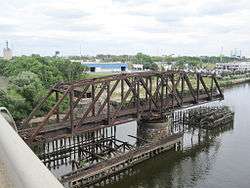
The railroad promptly began construction of a one-track bridge, completed in October 1902. This bridge has a 226-foot-7-inch (69.1 m) swing span pivoting on a cylindrical stone pier at mid-stream, flanked by a 97-foot-9 3⁄8-inch (29.8 m) approach span on either side.[16][35] A wooden pile fender protects the pivot pier and the opened swing span from collisions with boat traffic on the river.[16]
On April 14, 1945, the funeral train carrying the body of President Franklin D. Roosevelt passed over the bridge, where mourners gathered to watch its passage.[9]
In 1976, Conrail abandoned the bridge shortly after it acquired the Pennsylvania Railroad properties and left it permanently open. An unknown party purchased the bridge in 1987.[16] Today, the bridge and the fender pilings continue to exist, deteriorating.
In 2012, Philadelphia Mayor Michael Nutter proposed to return the bridge to service as a part of the Schuylkill River Trail, a bike trail.[36]
Grays Ferry Avenue Bridge (1976-present)
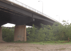
In 1976, the Pennsylvania State Highway Agency built a highway bridge to replace the 1901 structure. The new bridge was erected between the old road bridge and the PW&B railroad bridge.[37]
The 1,482-foot (452 m) bridge carries Grays Ferry Avenue across the river and the Northeast Corridor main line. Built of steel girders, it has four traffic lanes and two pedestrian sidewalks.[1] There are also "painted, unbuffered bike lanes, but high prevailing speeds on the immediately adjacent motor vehicle lanes and significant debris in the bike lanes make the bike lanes uncomfortable for many bicyclists," said a 2012 City of Philadelphia report.[38]
In 2007, PennDOT recorded average daily traffic volume of around 30,000 motor vehicles.[38]
See also
- List of bridges documented by the Historic American Engineering Record in Pennsylvania
- List of crossings of the Schuylkill River
- The Woodlands Cemetery
References
- 1 2 Svirsky, Alexander. "GRAYS FERRY AVENUE". The National Bridge Inventory Database. Retrieved November 23, 2012. Note: this site is a front-end to what the author says is a database built from data obtained annually from the Federal Highway Administration's National Bridge Inventory.
- 1 2 3 Scharf, John Thomas (1884). History of Philadelphia, 1609-1884, Volume 3. L. H. Everts & Company.
- 1 2 Report By Daughters of the American Revolution (1902)
- ↑ The Pennsylvania Magazine of History and Biography, Volume 46
- ↑ The Building of West Philadelphia / 18th Century Landscape & Settlement Patterns
- ↑ 1753 map in the Library of Congress
- ↑ History Of The Friendly Sons Of St. Patrick And Of The Hibernian Society For The Relief Of Emigrants From Ireland, March 17, 1771-March 17, 1892
- 1 2 3 4 5 6 Powers, Fred P. (1917). "Early Schuylkill Bridges". Publications of the City History Society of Philadelphia. 1: 267–316.
- 1 2 3 4 Philadelphia: A 300 Year History. W. W. Norton & Company. 1982. pp. 162, 168, 232, 644. Retrieved November 20, 2012.
- ↑ Russell Frank Weigley; Nicholas B. Wainwright; Edwin Wolf (1982). Philadelphia: A 300 Year History. W. W. Norton & Company. p. 232. Retrieved September 9, 2014.
- ↑ Hazard, Samuel (1828). The Register of Pennsylvania, Volume 1. Retrieved December 3, 2012.
- ↑ Philadelphia as it is: And Citizens' Advertising Directory Containing a General Description of the City and Environs, List of Officers, Public Institutions, and Other Useful Information : for the Convenience of Citizens, as a Book of Reference, and a Guide to Strangers : with a New Map of the City. Philadelphia: P.J. Gray. 1834.
- ↑ Wulf, Andrea (2011). Founding Gardeners: The Revolutionary Generation, Nature, and the Shaping of the American Nation. Random House Digital. p. 304. ISBN 978-0307269904.
- ↑ Washington, George (May 13, 1787). "Diary Entry: 13 May 1787". Founders Online. National Archive. Retrieved September 3, 2015.
- ↑ History of the Pennsylvania Railroad Company: With Plan of Organization, Portraits of Officials and Biographical Sketches, Volume 1 (1895)
- 1 2 3 4 5 6 7 8 Spivey, Justin M. (April 2000). "Philadelphia, Wilmington & Baltimore Railroad, Bridge No. 1" (PDF). Historic American Engineering Record. Washington, D.C.: Library of Congress. Retrieved January 29, 2014.
- 1 2 Dare, Charles P. (1856). Philadelphia, Wilmington and Baltimore Railroad Guide: Containing a Description of the Scenery, Rivers, Towns, Villages, and Objects of Interest Along the Line of Road : Including Historical Sketches, Legends, &c. Philadelphia: Fitzgibbon & Van Ness. p. 142.
- ↑ Wilson, William Bender. History of the Pennsylvania Railroad Company with Plan of Organization, Portraits of Officials and Biographical Sketches. 1. pp. 296–299.
- 1 2 Possibly Charles P. Dare (1877). Philadelphia, Wilmington and Baltimore Railroad Guide Book. p. 140.
- ↑ Second Annual Report of the Philadelphia, Wilmington and Baltimore Rail Road Company. Philadelphia: Philadelphia, Wilmington and Baltimore Rail Road Company. 1840. p. 62.
- ↑ West Philadelphia Illustrated: Early History of West Philadelphia and Its Environs, Its People, and Its Historical Points (1903)
- ↑ Philadelphia History, Volume 2 By City History Society of Philadelphia
- ↑ "1948 original railroads in Philadelphia". From a 1948 PRR Board of Directors Inspection of Physical Property. 1948. Retrieved November 24, 2012 – via WikiMedia Commons. This map inaccurately shows the PW&B crossing the Schuylkill on the PRR's Arsenal Bridge.
- ↑ Philaphilia: Empty Lot of the Week-- June 16th
- ↑ http://supreme.justia.com/us/70/713/
- ↑ Caswell, Bill (2007). "Lower Ferry or Gray's Ferry or Matthew Newkirk's Viaduct, Philadelphia County". Documenting North America's past & present covered bridges. lostbridges.org. Retrieved November 23, 2012.
- ↑ First Annual Report of the Philadelphia, Wilmington and Baltimore Rail Road Company. Philadelphia: Philadelphia, Wilmington and Baltimore Rail Road Company. 1839. p. 62.
- ↑ "New Map of the City of Philadelphia (J.L. Smith, publisher, 1907)". GeoHistory Resources. Greater Philadelphia GeoHistory Network. Retrieved December 3, 2012.
- ↑ McBride's Magazine, Volume 12 (1873)
- ↑ After the Improvement opened, the PW&B's stations, from the northern terminal at Broad and Washington, were: Arsenal, Gray's Ferry, 58th Street, Mount Moriah, Bonnafon, Paschal, Darby, Sharon Hill, Glenolden, Norwood, etc.
- 1 2 3 4 5 "City's Fine New Bridge". Philadelphia. Philadelphia Record. August 12, 1900. p. 15. Retrieved September 25, 2013.
- 1 2 Ashbridge, Samuel H.; William C. Haddock, et. al (1902). Annual Message of the Mayor of the City of Philadelphia with the Annual Reports of Directors of Departments, Volume 2. Philadelphia, Pennsylvania: City of Philadelphia. pp. 431–434.
- ↑ West Philadelphia Illustrated: Early History of West Philadelphia and Its Environs, Its People, and Its Historical Points (1903)
- ↑ Water Resources of the Philadelphia District, p.54
- ↑ Amman & Whitney (February 2012). "Grays Ferry Pedestrian Bridge Conceptual Design Report" (PDF). Schuylkill River Development Corporation. p. 174. Retrieved November 23, 2012.
- ↑ Hill, Miriam (November 20, 2012). "Proposed bike trail would cross Schuylkill, access Bartram's Garden". Philadelphia Inquirer.
- ↑ Aerial Survey of Philadelphia, PA, 1930 (circa) Plate 9
- 1 2 "APPENDIX E: LOCATIONS FOR BICYCLE NETWORK IMPROVEMENTS REQUIRING ADDITIONAL STUDY" (PDF). CITY OF PHILADELPHIA PEDESTRIAN & BICYCLE PLAN. City of Philadelphia. April 2012. Retrieved September 3, 2015.
External links
| Wikimedia Commons has media related to Gray's Ferry Bridge. |
- Letter of Capt. Richard Delafield, of the U.S. Engineer corps, to Matthew Newkirk, esq., president of the Philadelphia, Wilmington and Baltimore Rail Road Company, relative to a rail road bridge to be constructed over the Schuylkill at Gray's Ferry (1837).
- Reviving Schuylkill: Eight Miles From the Dam to Ft. Mifflin
- "The River As It Was, The River As It Is, The River As It Should Be" By John Frederick Lewis of the City Parks Association, Philadelphia, 1924.
- Three 1924 photos from Gray's Ferry Bridge north to the outlet of Mill Creek and The Woodlands: Photo 1, Photo 2, Photo 3
- 1924 photo labeled "The Present State of the East Bank of the Schuylkill at Gray's Ferry Where Our Citizens Met Washington on His Way to His Inauguration."
- 1924 photo labeled "Looking down the River, East Bank, Below Gray's Ferry Where Our Citizens Assembled to Greet Washington."
- 1924 photo labeled "The West Bank of the River, South of Gray's Ferry Bridge, Open Sewers and Filth Having Replaced Beauty."
- "Mirror of the City": images through the years
- 1925 aerial photo of the bridges and surrounding area
- 1928 aerial photo of the bridges and surrounding area
- 1936 aerial photo shows Grays Ferry Bridge and PW&B No. 1
- 1956 drawing of proposed Gray's Ferry Avenue Bridge