Grasshopper Township, Atchison County, Kansas
| Grasshopper Township | |
|---|---|
| Township | |
 Location in Atchison County | |
| Coordinates: 39°35′48″N 095°26′15″W / 39.59667°N 95.43750°WCoordinates: 39°35′48″N 095°26′15″W / 39.59667°N 95.43750°W | |
| Country | United States |
| State | Kansas |
| County | Atchison |
| Area | |
| • Total | 66.0 sq mi (170.9 km2) |
| • Land | 65.7 sq mi (170.2 km2) |
| • Water | 0.3 sq mi (0.7 km2) 0.41% |
| Elevation | 1,076 ft (328 m) |
| Population (2010) | |
| • Total | 567 |
| • Density | 9/sq mi (3.3/km2) |
| GNIS feature ID | 0473240 |
Grasshopper Township is a township in Atchison County, Kansas, United States. As of the 2010 census, its population was 567.[1]
History
Grasshopper Township was established in 1855 as one of the three original townships of Atchison County.[2]
Geography
Grasshopper Township covers an area of 66.0 square miles (170.9 km2) and contains one incorporated settlement, Muscotah. According to the USGS, it contains three cemeteries: Brush Creek, Forest Grove and Wheatland.
The streams of Brush Creek, Clear Creek, Little Delaware River, Little Grasshopper Creek, Mission Creek, Otter Creek and South Creek run through this township.
References
- ↑ "Geographic Identifiers: 2010 Demographic Profile Data (G001): Grasshopper township, Atchison County, Kansas". U.S. Census Bureau, American Factfinder. Retrieved May 13, 2013.
- ↑ Ingalls, Sheffield (1916). History of Atchison County, Kansas. Standard Publishing Company. p. 64.
External links
Municipalities and communities of Atchison County, Kansas, United States | ||
|---|---|---|
| Cities | 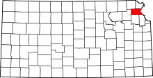 | |
| Unincorporated communities | ||
| Indian reservations | ||
| Townships | ||
| Ghost towns | ||
| Footnotes | ‡This populated place also has portions in an adjacent county or counties | |
This article is issued from Wikipedia - version of the 10/30/2016. The text is available under the Creative Commons Attribution/Share Alike but additional terms may apply for the media files.