| Name |
Location |
Date Listed |
Grid Ref.[note 1]
Geo-coordinates |
Function |
Notes |
HB No[note 2] |
Image |
| Pele Tower |
Angle |
000000001970-05-14-000014 May 1970 |
SM8660702994
51°41′06″N 5°05′18″W / 51.685002246264°N 5.0884378337723°W / 51.685002246264; -5.0884378337723 (Pele Tower) |
Pele tower |
About 100 m N of St Mary's Church, close to Castle Farm. |
5923 |
 Upload another image
|
| Caldey Priory, including church and monastery remains |
Tenby |
000000001970-05-14-000014 May 1970 |
SS1408596316
51°38′05″N 4°41′16″W / 51.634831481567°N 4.6878826669659°W / 51.634831481567; -4.6878826669659 (Caldey Priory, including church and monastery remains) |
Priory |
Situated some 300m S of the Abbey, on the W side of the road to the lighthouse. |
5932 |
 Upload another image
See more images
|
| Carew Castle |
Carew |
000000001970-05-14-000014 May 1970 |
SN0450003769
51°41′55″N 4°49′49″W / 51.698500981562°N 4.8303804204776°W / 51.698500981562; -4.8303804204776 (Carew Castle) |
Castle |
At the W of Carew Castle, 600 m N of the A477 |
5937 |
 Upload another image
See more images
|
| The Carew Cross |
Carew |
000000001970-05-14-000014 May 1970 |
SN0467603708
51°41′53″N 4°49′40″W / 51.698014678274°N 4.8278027897843°W / 51.698014678274; -4.8278027897843 (The Carew Cross) |
Cross |
In Carew village, in a small roadside enclosure taken from Castle Green opposite the Carew Inn. |
5938 |
 Upload another image
See more images
|
| Old Mortuary Chapel |
Carew |
000000001970-05-14-000014 May 1970 |
SN0453302831
51°41′24″N 4°49′46″W / 51.690089138599°N 4.8293777654072°W / 51.690089138599; -4.8293777654072 (Old Mortuary Chapel) |
Chapel |
In St Mary's Churchyard, about 30m NW of the Church. |
5945 |
.jpg) Upload another image
|
| St Michael's Church |
Castlemartin |
000000001970-05-14-000014 May 1970 |
SR9106098880
51°38′59″N 5°01′18″W / 51.649745206237°N 5.0216556179063°W / 51.649745206237; -5.0216556179063 (St Michael's Church) |
Church |
In a lane NW of Castlemartin village. |
5948 |
 Upload another image
|
| St James's Church |
Manorbier |
000000001970-05-14-000014 May 1970 |
SS0650197645
51°38′39″N 4°47′53″W / 51.644200724086°N 4.7980689201978°W / 51.644200724086; -4.7980689201978 (St James's Church) |
Church |
|
5975 |
 Upload another image
See more images
|
| Manorbier Castle |
Manorbier |
000000001970-05-14-000014 May 1970 |
SS0639597793
51°38′44″N 4°47′59″W / 51.645493225248°N 4.79968091366°W / 51.645493225248; -4.79968091366 (Manorbier Castle) |
Castle |
|
5976 |
 Upload another image
See more images
|
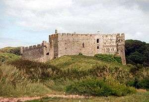
| Lydstep Palace |
Manorbier |
000000001970-05-14-000014 May 1970 |
SS0863098375
51°39′05″N 4°46′04″W / 51.651487604333°N 4.767736624142°W / 51.651487604333; -4.767736624142 (Lydstep Palace) |
Bishop's palace |
At N of the A4139 in the centre of Lydstep Village, immediately opposite to Lydstep Tavern. |
5991 |
 Upload another image
|
| Church Of St Mary |
Carew |
000000001970-05-14-000014 May 1970 |
SN0456902804
51°41′23″N 4°49′44″W / 51.689859249631°N 4.8288424824323°W / 51.689859249631; -4.8288424824323 (Church Of St Mary) |
Church |
In Carew Cheriton, 300m S of the A477. |
6007 |
.jpg) Upload another image
|
| St Elidyr's Church |
Stackpole Elidor, Stackpole, Stackpole and Castlemartin |
000000001970-05-14-000014 May 1970 |
SR9872597303
51°38′18″N 4°54′36″W / 51.638391003695°N 4.9101065262818°W / 51.638391003695; -4.9101065262818 (St Elidyr's Church) |
Church |
|
6020 |
 Upload another image
|
| Upton Chapel |
Cosheston |
000000001970-05-14-000014 May 1970 |
SN0209104699
51°42′22″N 4°51′57″W / 51.706005073458°N 4.8657210817632°W / 51.706005073458; -4.8657210817632 (Upton Chapel) |
Chapel |
A small chapel in close proximity to Upton Castle. It is reached by a private path from the Castle. |
6032 |
 Upload another image
See more images
|
| Amroth Castle |
Amroth |
000000001951-04-12-000012 April 1951 |
SN1697007241
51°44′02″N 4°39′07″W / 51.733903677124°N 4.6519738112808°W / 51.733903677124; -4.6519738112808 (Amroth Castle) |
Country House |
At the N side of the unclassified coast road about ? km E of the village of Amroth. A high wall screens the castle grounds from the road, with an entrance archway at the SW corner. A tree-lined drive leads to the Castle. |
6041 |
.jpg) Upload another image
|
| Picton Castle |
Slebech |
000000001971-06-21-000021 June 1971 |
SN0107613430
51°47′03″N 4°53′07″W / 51.784046211355°N 4.8853859624894°W / 51.784046211355; -4.8853859624894 (Picton Castle) |
Castle |
2 km S of the A40(T) road, in extensive private grounds overlooking the Daugleddau confluence. |
6043 |
 Upload another image
See more images
|
| Llawhaden Castle |
Llawhaden |
000000001971-06-21-000021 June 1971 |
SN0730317465
51°49′21″N 4°47′51″W / 51.822468097315°N 4.7974692811161°W / 51.822468097315; -4.7974692811161 (Llawhaden Castle) |
Castle |
To the W of Llawhaden Village, standing within a wide dry moat, at the head of a steep slope above the Eastern Cleddau. |
6065 |
 Upload another image
See more images
|
| Church of Saint Mary in Liberty |
Tenby |
000000001951-03-19-000019 March 1951 |
SN1342400447
51°40′18″N 4°41′59″W / 51.671713308694°N 4.6996277776225°W / 51.671713308694; -4.6996277776225 (Church of Saint Mary in Liberty) |
Church |
In a prominent position on the SW side of the High Street just NW of Tudor Square. |
6177 |
 Upload another image
See more images
|
| Tudor Merchant's House |
Tenby |
000000001951-03-19-000019 March 1951 |
SN1353000440
51°40′18″N 4°41′53″W / 51.671685745827°N 4.6980929209997°W / 51.671685745827; -4.6980929209997 (Tudor Merchant's House) |
House |
Situated on the W side of Quay Hill facing down Bridge Street. |
6226 |
 Upload another image
|
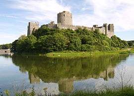
| Pembroke Castle |
Pembroke |
000000001951-02-10-000010 February 1951 |
SM9816401620
51°40′37″N 4°55′15″W / 51.676953714184°N 4.9206956084913°W / 51.676953714184; -4.9206956084913 (Pembroke Castle) |
Castle |
Situated prominently at the high W end of the ridge on which the old town of Pembroke is built. |
6314 |
 Upload another image
See more images
|
| Priory Church of Saint Nicholas |
Monkton, Pembroke |
000000001951-02-10-000010 February 1951 |
SM9796201451
51°40′31″N 4°55′25″W / 51.675363309528°N 4.9235153718462°W / 51.675363309528; -4.9235153718462 (Priory Church of Saint Nicholas) |
Church |
In a prominent position in Monkton approximately 200m SW of Pembroke Castle. |
6330 |
 Upload another image
|
| Monkton Old Hall |
Monkton, Pembroke |
000000001951-02-10-000010 February 1951 |
SM9805401432
51°40′31″N 4°55′20″W / 51.675225900933°N 4.9221756346237°W / 51.675225900933; -4.9221756346237 (Monkton Old Hall) |
Hall |
On the N side of Church Terrace in Monkton some 60m E of the Priory Church of Saint Nicholas. |
6332 |
 Upload another image
|
| Parish Church of Saint Mary |
Pembroke |
000000001951-02-10-000010 February 1951 |
SM9835801540
51°40′35″N 4°55′04″W / 51.676305282553°N 4.9178473688°W / 51.676305282553; -4.9178473688 (Parish Church of Saint Mary) |
Church |
In a prominent position on the N side of Main Street just E of its junction with Northgate Street. |
6400 |
.jpg) Upload another image
|
| Church of Saint Daniel |
Pembroke |
000000001951-02-10-000010 February 1951 |
SM9821200476
51°40′00″N 4°55′10″W / 51.666698513145°N 4.9193412503401°W / 51.666698513145; -4.9193412503401 (Church of Saint Daniel) |
|
In a prominent position on a hill some 1.1km S of Pembroke Castle. |
6453 |
 Upload another image
|
| Narberth Castle |
Narberth |
000000001951-09-25-000025 September 1951 |
SN1097814392
51°47′46″N 4°44′33″W / 51.796130042304°N 4.7425342640491°W / 51.796130042304; -4.7425342640491 (Narberth Castle) |
Castle |
|
6473 |
 Upload another image
See more images
|
| St Decuman's Church |
Rhoscrowther, Hundleton |
000000001970-05-14-000014 May 1970 |
SM9039502204
51°40′46″N 5°02′00″W / 51.67934146215°N 5.0332480739914°W / 51.67934146215; -5.0332480739914 (St Decuman's Church) |
Church |
|
6591 |
 Upload another image
See more images
|
| Tower at Eastington Manor House |
Hundleton |
000000001970-05-14-000014 May 1970 |
SM9009702512
51°40′55″N 5°02′16″W / 51.681995121804°N 5.0377372135488°W / 51.681995121804; -5.0377372135488 (Tower at Eastington Manor House) |
Farmhouse |
|
6594 |
 Upload another image
|
| Ffynone Mansion |
Manordeifi |
000000001952-01-16-000016 January 1952 |
SN2422338605
52°01′05″N 4°33′47″W / 52.017940473921°N 4.5630325133808°W / 52.017940473921; -4.5630325133808 (Ffynone Mansion) |
Country House |
|
11980 |
 Upload another image
|
| Roch Castle |
Roch, Nolton and Roch |
000000001951-12-13-000013 December 1951 |
SM8802921212
51°50′57″N 5°04′44″W / 51.84910498642°N 5.0790178766808°W / 51.84910498642; -5.0790178766808 (Roch Castle) |
Castle |
Situated in centre of Roch village, on a rocky knoll visible from considerable distances. |
11982 |
 Upload another image
See more images
|
| St Michael's Church |
Rudbaxton |
000000001963-01-03-00003 January 1963 |
SM9602720561
51°50′47″N 4°57′46″W / 51.846250689277°N 4.9626816243236°W / 51.846250689277; -4.9626816243236 (St Michael's Church) |
Church |
Situated some 600m E of the A40 in the centre of Rudbaxton just NW of Great Rudbaxton. |
12009 |
 Upload another image
|
| Haverfordwest Castle |
Haverfordwest |
000000001951-12-10-000010 December 1951 |
SM9534315728
51°48′09″N 4°58′11″W / 51.802604861847°N 4.9697399165267°W / 51.802604861847; -4.9697399165267 (Haverfordwest Castle) |
Castle |
Situated on hill in centre of the town. |
12031 |
 Upload another image
See more images
|
| St Mary's Church |
Haverfordwest |
000000001951-12-10-000010 December 1951 |
SM9519115569
51°48′04″N 4°58′19″W / 51.801121370591°N 4.9718473569213°W / 51.801121370591; -4.9718473569213 (St Mary's Church) |
Church |
Situated at the head of the High Street. |
12226 |
 Upload another image
See more images
|
| Remains of Priory of Saint Mary and Saint Thomas the Martyr |
Haverfordwest |
000000001974-01-07-00007 January 1974 |
SM9569115219
51°47′53″N 4°57′52″W / 51.798162322961°N 4.9643998172684°W / 51.798162322961; -4.9643998172684 (Remains of Priory of Saint Mary and Saint Thomas the Martyr) |
Priory (ruined) |
Situated on the riverside at the end of Quay Street. |
12240 |
 Upload another image
See more images
|
| St David's Cathedral |
St David's and the Cathedral Close |
000000001963-01-03-00003 January 1963 |
SM7515625430
51°52′55″N 5°16′06″W / 51.881910318675°N 5.2683484460942°W / 51.881910318675; -5.2683484460942 (St David's Cathedral) |
Cathedral |
|
12537 |
 Upload another image
See more images
|
| St David's Cathedral Hall (formerly chapel of St Mary's College) and attached cloister ruins |
St David's and the Cathedral Close |
000000001951-12-13-000013 December 1951 |
SM7514425474
51°52′56″N 5°16′07″W / 51.882300410337°N 5.26855117324°W / 51.882300410337; -5.26855117324 (St David's Cathedral Hall (formerly chapel of St Mary's College) and attached cloister ruins) |
Chapel |
|
12538 |
 Upload another image
See more images
|
| Porth-y-Tŵr, including gateway and South Tower |
St Davids and the Cathedral Close |
000000001963-01-03-00003 January 1963 |
SM7520425363
51°52′53″N 5°16′03″W / 51.881328350578°N 5.2676085880808°W / 51.881328350578; -5.2676085880808 (Porth-y-Tŵr, including gateway and South Tower) |
Gateway |
|
12541 |
 Upload another image
See more images
|
| Cloister Hall |
St David's and the Cathedral Close |
000000001963-01-03-00003 January 1963 |
SM7517825487
51°52′57″N 5°16′05″W / 51.882430868617°N 5.2680664951354°W / 51.882430868617; -5.2680664951354 (Cloister Hall) |
Cloister hall |
|
12553 |

|
| Outbuilding to the north of the Cloister Hall |
St David's and the Cathedral Close |
000000001963-01-03-00003 January 1963 |
SM7518525499
51°52′57″N 5°16′05″W / 51.882541416989°N 5.2679727835366°W / 51.882541416989; -5.2679727835366 (Outbuilding to the north of the Cloister Hall) |
Outbuilding |
|
12554 |
|
| Undercrofts of the former St Mary's Colle, beneath and to the rear of the Cloister Hall |
St David's and the Cathedral Close |
000000001963-01-03-00003 January 1963 |
SM7516125496
51°52′57″N 5°16′06″W / 51.882504770272°N 5.2683189357454°W / 51.882504770272; -5.2683189357454 (Undercrofts of the former St Mary's Colle, beneath and to the rear of the Cloister Hall) |
Undercroft |
|
12555 |
|
| Enclosing wall and gateway on the north side of the rear yard of the Cloister Hall |
St David's and the Cathedral Close |
000000001963-01-03-00003 January 1963 |
SM7515925507
51°52′57″N 5°16′06″W / 51.882602698175°N 5.2683551133647°W / 51.882602698175; -5.2683551133647 (Enclosing wall and gateway on the north side of the rear yard of the Cloister Hall) |
Wall/Gateway |
|
12556 |
|
| Bishop's Palace |
St David's and the Cathedral Close |
000000001963-01-03-00003 January 1963 |
SM7502825469
51°52′56″N 5°16′13″W / 51.882208540317°N 5.2702304196862°W / 51.882208540317; -5.2702304196862 (Bishop's Palace) |
Bishop's palace |
|
12558 |
 Upload another image
See more images
|
| Ruins of St Justinian's Chapel |
St Justinian's |
000000001963-01-03-00003 January 1963 |
SM7231525240
51°52′45″N 5°18′34″W / 51.879047166887°N 5.3094283210591°W / 51.879047166887; -5.3094283210591 (Ruins of St Justinian's Chapel) |
Chapel (ruined) |
|
12692 |
 Upload another image
|
| St David's Church |
Hubberston, Milford Haven |
000000001951-07-17-000017 July 1951 |
SM8906806233
51°42′54″N 5°03′17″W / 51.715016441932°N 5.054850391453°W / 51.715016441932; -5.054850391453 (St David's Church) |
Church |
Situated in churchyard behind C20 shops in Gelleswick Road. |
12925 |
.jpg) Upload another image
|
| Newport Castle, Feidr Felin |
Newport |
000000001952-01-16-000016 January 1952 |
SN0570838870
52°00′51″N 4°49′58″W / 52.014127074192°N 4.8326642743407°W / 52.014127074192; -4.8326642743407 (Newport Castle, Feidr Felin) |
Castle |
|
13083 |
 Upload another image
See more images
|
| Ruins of St Mary's Abbey, Shinrig |
St Dogmaels (part) |
000000001993-11-15-000015 November 1993 |
SN1640445855
52°04′50″N 4°40′51″W / 52.080511295027°N 4.6807443334662°W / 52.080511295027; -4.6807443334662 (Ruins of St Mary's Abbey, Shinrig) |
Abbey (ruined) |
|
13102 |
 Upload another image
See more images
|
| Paterchurch Tower, The Dockyard |
Pembroke Dock |
000000001981-07-14-000014 July 1981 |
SM9576303558
51°41′37″N 4°57′23″W / 51.693484302558°N 4.956507736873°W / 51.693484302558; -4.956507736873 (Paterchurch Tower, The Dockyard) |
Tower |
|
14341 |
|
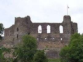
| Cilgerran Castle |
Cilgerran |
000000001994-04-15-000015 April 1994 |
SN1949843135
52°03′26″N 4°38′03″W / 52.057103422072°N 4.6342049013012°W / 52.057103422072; -4.6342049013012 (Cilgerran Castle) |
Castle |
|
14491 |
 Upload another image
See more images
|
| Stable and kitchen court, Ffynnonau |
Manordeifi |
000000001952-01-16-000016 January 1952 |
SN2426738641
52°01′06″N 4°33′45″W / 52.018277790528°N 4.5624104781571°W / 52.018277790528; -4.5624104781571 (Stable and kitchen court, Ffynnonau) |
House |
|
15122 |
|
| West Tarr Mediaeval House |
Penally |
000000001996-04-26-000026 April 1996 |
SN0889600800
51°40′24″N 4°45′55″W / 51.673356571632°N 4.765222792103°W / 51.673356571632; -4.765222792103 (West Tarr Mediaeval House) |
House |
At the rear of West Tarr farmhouse, 0.5 km SE of St Florence village. |
16920 |
|
| Whitewell Ruins – structure A |
Penally |
000000001970-05-14-000014 May 1970 |
SS0948499060
51°39′29″N 4°45′21″W / 51.657930439143°N 4.7557804918382°W / 51.657930439143; -4.7557804918382 (Whitewell Ruins – structure A) |
Manor house (ruined) |
At the N side of the A4139 about 1 km E of Lydstep. The ruins are situated at the S of a caravan park behind Whitewell Farm. |
6004 |
|
| Whitewell Ruins – Structure B |
Penally |
000000001996-04-26-000026 April 1996 |
SS0948999035
51°39′28″N 4°45′21″W / 51.657707620188°N 4.7556946655567°W / 51.657707620188; -4.7556946655567 (Whitewell Ruins – Structure B) |
Ruin |
At the N side of the A4139 about 1 km E of Lydstep. The ruins are situated at the S of a caravan park behind Whitewell Farm. |
16922 |
|
| Whitewell Ruins – Structure C |
Penally |
000000001996-04-26-000026 April 1996 |
SS0947299053
51°39′28″N 4°45′21″W / 51.657863492862°N 4.7559499486243°W / 51.657863492862; -4.7559499486243 (Whitewell Ruins – Structure C) |
Ruin |
At the N side of the A4139 about 1 km E of Lydstep. The ruins are situated at the S of a caravan park behind Whitewell Farm. |
16923 |
|
| Sailors' Chapel |
Angle |
000000001970-05-14-000014 May 1970 |
SM8663902926
51°41′04″N 5°05′17″W / 51.684403945751°N 5.0879340565568°W / 51.684403945751; -5.0879340565568 (Sailors' Chapel) |
Chapel |
At N side of St Mary's Church, within the Churchyard. |
17147 |
|
| Lamphey Bishop's Palace |
Lamphey |
000000001970-05-14-000014 May 1970 |
SN0185000895
51°40′18″N 4°52′01″W / 51.671760370698°N 4.8670436123277°W / 51.671760370698; -4.8670436123277 (Lamphey Bishop's Palace) |
Bishop's palace |
Reached by minor road at N of Lamphey village. |
17393 |
 Upload another image
See more images
|
| St Govan's Chapel |
Stackpole, Stackpole and Castlemartin |
000000001996-08-02-00002 August 1996 |
SR9670592962
51°35′55″N 4°56′12″W / 51.598682365878°N 4.936737789589°W / 51.598682365878; -4.936737789589 (St Govan's Chapel) |
Chapel |
|
17980 |
 Upload another image
See more images
|
| Tenby Town Walls |
Tenby |
000000002002-03-28-000028 March 2002 |
SN1334600380
51°40′16″N 4°42′03″W / 51.671085578505°N 4.7007186322418°W / 51.671085578505; -4.7007186322418 (Tenby Town Walls) |
Town walls |
The walls run W along White Lion Street from corner of Upper Frog St, and then S along South Parade and St Florence Parade to the sea. |
26434 |
 Upload another image
See more images
|
| Wiston Castle |
Wiston |
000000002004-06-16-000016 June 2004 |
SN0226118180
51°49′38″N 4°52′15″W / 51.827121083612°N 4.8709400359035°W / 51.827121083612; -4.8709400359035 (Wiston Castle) |
Castle |
In a prominent position near the centre of Wiston some 200m N of the Church of Saint Mary. |
82851 |
 Upload another image
|