| Name |
Location |
Date Listed |
Grid Ref.[note 1]
Geo-coordinates |
Function |
Notes |
HB No[note 2] |
Image |
| Church of St Margaret Marloes, Eglwyscummin |
Eglwyscummin |
000000001966-11-30-000030 November 1966 |
SN2309010649
51°45′59″N 4°33′55″W / 51.766485359737°N 4.5651784716532°W / 51.766485359737; -4.5651784716532 (Church of St Margaret Marloes, Eglwyscummin) |
Church |
Situated in a prominent position on the N side of the B4314, some 2.5km SE of Rhos-goch. |
9389 |
 Upload another image
See more images
|
| Llansteffan Castle |
Llansteffan |
000000001966-11-30-000030 November 1966 |
SN3514110148
51°45′56″N 4°23′26″W / 51.765673538851°N 4.3904680276349°W / 51.765673538851; -4.3904680276349 (Llansteffan Castle) |
Castle |
Prominently situated on a rocky promontery, overlooking the mouth of the Tywi. |
9405 |
 Upload another image
See more images
|
| St Peter's Church, Carmarthen |
Carmarthen |
000000001954-08-18-000018 August 1954 |
SN4152320221
51°51′29″N 4°18′10″W / 51.858014060302°N 4.3026750809433°W / 51.858014060302; -4.3026750809433 (St Peter's Church, Carmarthen) |
Church |
Situated in rounded churchyard at end of King Street. |
9435 |
 Upload another image
See more images
|
| Carmarthen Castle |
Carmarthen |
000000001954-08-18-000018 August 1954 |
SN4130820006
51°51′22″N 4°18′21″W / 51.856021331313°N 4.3056956078448°W / 51.856021331313; -4.3056956078448 (Carmarthen Castle) |
Castle |
Situated behind buildings on E side of Nott's Square. |
9507 |
 Upload another image
See more images
|
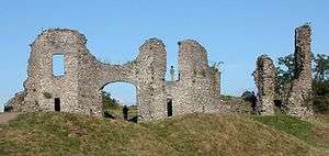
| Outer Gatehouse to Laugharne Castle |
Laugharne Township |
000000001986-09-25-000025 September 1986 |
SN3020210794
51°46′12″N 4°27′44″W / 51.769996314861°N 4.4622874287369°W / 51.769996314861; -4.4622874287369 (Outer Gatehouse to Laugharne Castle) |
Gatehouse |
At the bottom of the street near the Town Hall, reached by path in front of Castle House. |
9652 |
 Upload another image
|
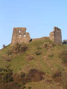
| Laugharne Castle |
Laugharne Township |
000000001966-11-30-000030 November 1966 |
SN3021710752
51°46′11″N 4°27′43″W / 51.769623603298°N 4.462049709389°W / 51.769623603298; -4.462049709389 (Laugharne Castle) |
Castle |
On an elevated coastal site near the Town Hall, reached by path in front of Castle House. |
9653 |
 Upload another image
See more images
|
| Newcastle Emlyn Castle |
Newcastle Emlyn |
000000001991-05-08-00008 May 1991 |
SN3114240724
52°02′21″N 4°27′48″W / 52.039128924761°N 4.4633503651072°W / 52.039128924761; -4.4633503651072 (Newcastle Emlyn Castle) |
Castle |
Sited on a peninsula to W of the town. Pedestrian access from Castle Street. |
9716 |
 Upload another image
See more images
|
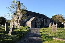
| Church of St Michael, Cilycwm |
Cilycwm |
000000001966-08-07-00007 August 1966 |
SN7533340029
52°02′41″N 3°49′09″W / 52.044611649089°N 3.8192098171757°W / 52.044611649089; -3.8192098171757 (Church of St Michael, Cilycwm) |
Church |
Situated on E side of village street, in centre of village. |
10906 |
 Upload another image
|
| Plas Taliaris |
Manordeilo and Salem |
000000001966-08-07-00007 August 1966 |
SN6400427984
51°56′01″N 3°58′46″W / 51.93371443426°N 3.9795174176033°W / 51.93371443426; -3.9795174176033 (Plas Taliaris) |
Hall |
Situated 2km NE of Salem. |
10911 |
 Upload another image
|
| Dryslwyn Castle |
Llangathen |
000000001966-08-07-00007 August 1966 |
SN5540320365
51°51′47″N 4°06′05″W / 51.863086444876°N 4.1013355233841°W / 51.863086444876; -4.1013355233841 (Dryslwyn Castle) |
Castle |
On high ground overlooking the Tywi Valley, to the E of the B4297 and on the N side of the river. |
10934 |
 Upload another image
See more images
|
| Church of St Michael, Myddfai |
Myddfai |
000000001966-08-07-00007 August 1966 |
SN7723830139
51°57′22″N 3°47′16″W / 51.956163311575°N 3.7879016017424°W / 51.956163311575; -3.7879016017424 (Church of St Michael, Myddfai) |
Church |
Situated in rounded churchyard in centre of the village. |
10957 |
 Upload another image
|
| Dolauhirion Bridge |
Llandovery |
000000001966-08-03-00003 August 1966 |
SN7619736098
52°00′34″N 3°48′19″W / 52.009481070973°N 3.8051949579892°W / 52.009481070973; -3.8051949579892 (Dolauhirion Bridge) |
Bridge |
Situated some 1.5km north of Llandovery, carrying road to Cilycwm and Porthrhyd across River Tywi. |
10964 |
 Upload another image
|
| Church of St Mary, Llandovery |
Llandovery |
000000001966-08-03-00003 August 1966 |
SN7698335161
52°00′04″N 3°47′36″W / 52.001236071187°N 3.7934124878727°W / 52.001236071187; -3.7934124878727 (Church of St Mary, Llandovery) |
Church |
Situated on small hill above the modern A483 in large churchyard. |
10967 |
 Upload another image
See more images
|
| Dinefwr Castle |
Llandeilo |
000000001966-08-07-00007 August 1966 |
SN6114921730
51°52′37″N 4°01′07″W / 51.876814284337°N 4.0184949735057°W / 51.876814284337; -4.0184949735057 (Dinefwr Castle) |
Castle |
Situated on a rocky, wooded ridge above Afon Tywi. |
11117 |
 Upload another image
See more images
|
| Kidwelly Castle |
Kidwelly |
000000001963-12-05-00005 December 1963 |
SN4089707049
51°44′22″N 4°18′21″W / 51.739502562072°N 4.305709926741°W / 51.739502562072; -4.305709926741 (Kidwelly Castle) |
Castle |
Situated on a bluff above W bank of Gwendraeth Fach, across river from modern town centre. |
11876 |
 Upload another image
See more images
|
| Church of Saint Mary, Kidwelly |
Kidwelly |
000000001963-12-05-00005 December 1963 |
SN4084206750
51°44′12″N 4°18′23″W / 51.736800754749°N 4.3063689606529°W / 51.736800754749; -4.3063689606529 (Church of Saint Mary, Kidwelly) |
Church |
Situated in centre of Kidwelly in large walled churchyard. |
11878 |
 Upload another image
|
| Llanelly House (2 Bridge Street) |
Llanelli |
000000001966-06-17-000017 June 1966 |
SN5067300503
51°41′00″N 4°09′41″W / 51.683385690127°N 4.1614288066676°W / 51.683385690127; -4.1614288066676 (Llanelly House (2 Bridge Street)) |
House |
Situated on corner of Vaughan Street and Bridge Street, facing Parish Church. |
11892 |
 Upload another image
See more images
|
| Llanelly House (4 Bridge Street) |
Llanelli |
000000001966-06-17-000017 June 1966 |
SN5068000503
51°41′00″N 4°09′41″W / 51.683387556025°N 4.1613276288578°W / 51.683387556025; -4.1613276288578 (Llanelly House (4 Bridge Street)) |
House |
|
11893 |
Upload another image
See more images
|
| Llanelly House, rear wing (20 Vaughan Street) |
Llanelli |
000000001966-06-17-000017 June 1966 |
SN5066900489
51°41′00″N 4°09′41″W / 51.683258837302°N 4.1614806295338°W / 51.683258837302; -4.1614806295338 (Llanelly House, rear wing (20 Vaughan Street)) |
House |
|
11894 |
 Upload another image
|
| Llanelly House, rear wing (22 Vaughan Street) |
Llanelli |
000000001966-06-17-000017 June 1966 |
SN5066800496
51°41′00″N 4°09′41″W / 51.683321464011°N 4.1614980799895°W / 51.683321464011; -4.1614980799895 (Llanelly House, rear wing (22 Vaughan Street)) |
House |
|
11895 |

|
| Llanelly House (24 Vaughan Street) |
Llanelli |
000000001966-06-17-000017 June 1966 |
SN5066700502
51°41′00″N 4°09′41″W / 51.683375105962°N 4.1615151024159°W / 51.683375105962; -4.1615151024159 (Llanelly House (24 Vaughan Street)) |
House |
|
11896 |
|
| Dolauhirion Bridge |
Cilycwm |
000000001966-08-03-00003 August 1966 |
SN7620636100
52°00′34″N 3°48′18″W / 52.00950105493°N 3.8050646240583°W / 52.00950105493; -3.8050646240583 (Dolauhirion Bridge) |
Bridge |
Situated some 1.5km north of Llandovery, carrying road to Cilycwm and Porthrhyd across River Tywi |
16996 |
Upload another image
|
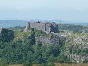
| Carreg Cennen Castle |
Dyffryn Cennen |
000000001998-11-24-000024 November 1998 |
SN6681419093
51°51′16″N 3°56′07″W / 51.854503676338°N 3.9352338825242°W / 51.854503676338; -3.9352338825242 (Carreg Cennen Castle) |
Castle |
Spectacularly set on a crag over the upper Cennen valley, approached from Carreg Cennen Farm, about 1.5 km E of Trap. |
20923 |
 Upload another image
See more images |