Grade I and II* listed buildings in Enfield
There are over 9,000 Grade I listed buildings and 20,000 Grade II* listed buildings in England. This page is a list of these buildings in the London Borough of Enfield.
Grade I
| Name | Location | Type | Completed [note 1] | Date designated | Grid ref.[note 2] Geo-coordinates |
Entry number [note 3] | Image |
|---|---|---|---|---|---|---|---|
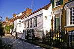
| Forty Hall | Forty Hill, Enfield | House | 1629–36 | 19 March 1951 | TQ3364098561 51°40′12″N 0°04′08″W / 51.669936°N 0.068881°W |
1294469 |  |
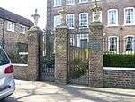
| Screen wall, gateway and north pavilions to west of Forty Hall | Forty Hill, Enfield | Gate | c. 1630 | 19 March 1951 | TQ3366598576 51°40′12″N 0°04′07″W / 51.670065°N 0.068514°W |
1079565 |  |
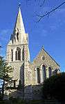
| Grovelands Park Hospital (original Block Only) | Enfield | Hospital | 1797 | 31 January 1974 | TQ3038694275 51°37′56″N 0°07′03″W / 51.632184°N 0.117504°W |
1078925 |  |
Grade II*


.jpg)


Notes
- 1 2 The date given is the date used by Historic England as significant for the initial building or that of an important part in the structure's description.
- 1 2 Sometimes known as OSGB36, the grid reference is based on the British national grid reference system used by the Ordnance Survey.
- 1 2 The "List Entry Number" is a unique number assigned to each listed building and scheduled monument by Historic England.
External links
-
 Media related to Grade I listed buildings in the London Borough of Enfield at Wikimedia Commons
 - Media related to Grade II* listed buildings in the London Borough of Enfield at Wikimedia Commons
| Districts |
|  |
|---|---|---|
| Attractions | ||
| Parks and open spaces | ||
| Constituencies | ||
| Tube and rail stations | ||
| Other topics | ||
This article is issued from Wikipedia - version of the 9/9/2016. The text is available under the Creative Commons Attribution/Share Alike but additional terms may apply for the media files.