Grade II* listed buildings in Medway
There are over 20,000 Grade II* listed buildings in England. This page is a list of these buildings in the district of Medway in Kent.
Medway
| Name | Location | Type | Completed [note 1] | Date designated | Grid ref.[note 2] Geo-coordinates |
Entry number [note 3] | Image |
|---|---|---|---|---|---|---|---|
| Slough Fort | Allhallows, Medway | Fort | 1867 | 12 November 2009 | TQ8377178519 51°28′33″N 0°38′41″E / 51.475779°N 0.64485°E |
1393526 | 
|
| The Rectory House | Cliffe and Cliffe Woods | House | 1679 | 21 November 1966 | TQ7333874867 51°26′47″N 0°29′35″E / 51.446263°N 0.492987°E |
1204092 |
|
| High Birch | Upper Bush, Cuxton | House | Later | 27 August 1952 | TQ6953066795 51°22′30″N 0°26′04″E / 51.3749°N 0.434387°E |
1281324 |
|
| Building LU001 (former B Magazine), Upnor Depot | Upnor, Frindsbury Extra | Magazine | 1856 to 1857 | 17 April 2009 | TQ7589470774 51°24′31″N 0°31′40″E / 51.408709°N 0.527699°E |
1393292 |
|
| 94–96 High Street | Halling | House | 19th century | 14 November 1986 | TQ7043164039 51°21′00″N 0°26′46″E / 51.349872°N 0.446°E |
1336494 |
|
| Church of St Mary | St Mary Hoo | House | 1966 | 21 November 1966 | TQ8037176593 51°27′34″N 0°35′42″E / 51.459572°N 0.594963°E |
1085756 |  |
| Berkeley House | Eastgate | House | Early 19th century | 24 October 1950 | TQ7454468195 51°23′09″N 0°30′25″E / 51.385959°N 0.507041°E |
1086501 |  |
| Bishop's Court with Bishop's Court Flat and Rear Flat Attached | Medway | Bishops Palace | 1845 | 24 October 1950 | TQ7412368338 51°23′15″N 0°30′04″E / 51.387372°N 0.501067°E |
1086434 |  |
| Bloors Place | Rainham | House | Early 16th century | 24 February 1950 | TQ8148067478 51°22′38″N 0°36′22″E / 51.377345°N 0.606246°E |
1267763 |
|
| Boer War Memorial Arch, Brompton Barracks | Brompton | Triumphal Arch | 1902 | 8 July 1998 | TQ7642869040 51°23′35″N 0°32′04″E / 51.392967°N 0.534508°E |
1375606 |  |
| Boilershop | Chatham Dockyard | Boiler Shop | 1984 | 6 June 1984 | TQ7640369941 51°24′04″N 0°32′05″E / 51.401068°N 0.534596°E |
1267821 |
|
| Brompton Barracks, Gymnasium | Brompton | Barracks | 1863 | 8 July 1998 | TQ7638968895 51°23′30″N 0°32′02″E / 51.391677°N 0.533876°E |
1375603 |
|
| Chatham Dock Pumping Station South | Chatham Dockyard | Boiler House | 1816-1823 | 13 August 1999 | TQ7595069294 51°23′43″N 0°31′40″E / 51.395397°N 0.52777°E |
1378623 |  |
| Chatham Memorial Synagogue | Rochester | Tower | 1865 | 2 December 1985 | TQ7511367905 51°22′59″N 0°30′54″E / 51.383178°N 0.515067°E |
1086467 |  |
| Church of St John the Divine | Chatham | Church | 1820-1821 | 29 October 1952 | TQ7563267820 51°22′56″N 0°31′21″E / 51.382255°N 0.522476°E |
1268218 |  |
| Church of St Mary Magdalen | Gillingham Green | Church | Early 13th century | 24 February 1950 | TQ7837468816 51°23′25″N 0°33′44″E / 51.390347°N 0.562337°E |
1267814 |  |
| Clock Tower Building | Chatham Dockyard | Mould Loft | 1723 | 24 May 1971 | TQ7593869214 51°23′41″N 0°31′39″E / 51.394682°N 0.527558°E |
1268241 |  |
| Cloudesley House, with Walls Attached at Rear | Medway | House | 1950 | 24 October 1950 | TQ7425568659 51°23′25″N 0°30′11″E / 51.390216°N 0.50312°E |
1299563 |  |
| College Green and Southgate and Garden Wall to Front | Rochester | Bishops Palace | 1459 | 24 October 1950 | TQ7420168496 51°23′20″N 0°30′08″E / 51.388768°N 0.502264°E |
1086427 |  |
| Crimean War Memorial Arch and Gates, Brompton Barracks | Brompton | Gate | 1856 | 8 July 1998 | TQ7637169063 51°23′35″N 0°32′01″E / 51.393191°N 0.533701°E |
1375607 |  |
| Foord Almshouses | Rochester | Statue | 1932 | 24 October 1950 | TQ7372067220 51°22′39″N 0°29′41″E / 51.377453°N 0.494735°E |
1329712 |  |
| Foord Almshouses Nos 1-47 with Gate and Forecourt Walls Attached | Medway | Gate | 1926 | 24 October 1950 | TQ7371567162 51°22′37″N 0°29′41″E / 51.376933°N 0.494635°E |
1329912 |  |
| Former Admirals Offices and Forecourt Walls and attached Iron Railings | Chatham Dockyard | Wall | 1809 | 24 May 1971 | TQ7590769144 51°23′39″N 0°31′37″E / 51.394063°N 0.527079°E |
1268199 |  |
| Former Assistant Queen's Harbourmaster's Office | Chatham Dockyard | Dockmasters Office | c. 1770 | 13 August 1999 | TQ7578769107 51°23′38″N 0°31′31″E / 51.393768°N 0.525337°E |
1378596 |
|
| Former Captain of the Dockyards House and Attached Front Area Railings | Chatham Dockyard | Naval Officers House | Early 19th century | 24 May 1971 | TQ7595569085 51°23′37″N 0°31′40″E / 51.393518°N 0.527739°E |
1268221 |
|
| Former Cashiers Office | Chatham Dockyard | Pay Office | Late 18th century | 24 May 1971 | TQ7594369074 51°23′36″N 0°31′39″E / 51.393423°N 0.527561°E |
1268222 |
|
| Former Guard House | Chatham Dockyard | Guardhouse | Early 19th century | 13 August 1999 | TQ7570368666 51°23′23″N 0°31′26″E / 51.389832°N 0.523913°E |
1378598 |  |
| Former Hatchelling House and Engine Room | Chatham Dockyard | Hatchelling House | 1787-1791 | 24 May 1971 | TQ7582569009 51°23′34″N 0°31′33″E / 51.392876°N 0.525834°E |
1268248 |  |
| Former Hemp House, Spinning Room and Offices | Chatham Dockyard | Ropery | Mid 19th century | 13 August 1999 | TQ7583968955 51°23′33″N 0°31′34″E / 51.392386°N 0.526009°E |
1378608 |
|
| Former Police Offices and attached Wall | Chatham Dockyard | Wall | 1764 | 24 May 1971 | TQ7590368926 51°23′32″N 0°31′37″E / 51.392106°N 0.526913°E |
1268200 |
|
| Former Tarred Yarn House | Chatham Dockyard | Capstan House | 1786-1791 | 13 August 1999 | TQ7581668868 51°23′30″N 0°31′32″E / 51.391612°N 0.525635°E |
1378610 |  |
| Former Wheelwrights' Shop | Chatham Dockyard | Mast House | Late C18/Early 19th century | 13 August 1999 | TQ7606469400 51°23′47″N 0°31′46″E / 51.396314°N 0.52946°E |
1378637 |  |
| Front and Perimeter Walls to Raised Gardens to Rear of Former Officers Terrace | Chatham Dockyard | Boundary Wall | c. 1731 | 13 August 1999 | TQ7604269120 51°23′38″N 0°31′44″E / 51.393806°N 0.529005°E |
1378599 |
|
| George Vaults | Medway | Public House | Late 18th century | 24 October 1950 | TQ7426768684 51°23′26″N 0°30′12″E / 51.390436°N 0.503304°E |
1186209 | 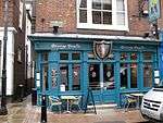 |
| Gordon Hotel | Medway | Town House | Late 17th century | 24 October 1950 | TQ7436368524 51°23′20″N 0°30′17″E / 51.38897°N 0.504604°E |
1336123 |  |
| Guard House West and Store | Chatham Dockyard | Guardhouse | Mid 19th century | 13 August 1999 | TQ7587768902 51°23′31″N 0°31′36″E / 51.391898°N 0.526528°E |
1378624 |
|
| Joiners Shop | Chatham Dockyard | Joiners Shop | Mid/Late 19th century | 13 August 1999 | TQ7598869259 51°23′42″N 0°31′42″E / 51.395071°N 0.528299°E |
1378612 |  |
| Lower Boat Store | Chatham Dockyard | Boat House | 1844 | 13 August 1999 | TQ7624169635 51°23′54″N 0°31′56″E / 51.39837°N 0.532118°E |
1378639 |
|
| Memorial to General Gordon, Brompton Barracks | Brompton | Statue | 1890 | 8 July 1998 | TQ7644969031 51°23′34″N 0°32′05″E / 51.39288°N 0.534805°E |
1375610 |
|
| Milton Cottage | Boley Hill | House | Post 1632 | 19 February 1970 | TQ7411768478 51°23′19″N 0°30′04″E / 51.388632°N 0.50105°E |
1086509 |  |
| No 60 (including Those Parts at Rear Facing College Green) Rear Part of 60 High Street | Medway | House | 1950 | 24 October 1950 | TQ7429468596 51°23′23″N 0°30′13″E / 51.389638°N 0.503649°E |
1299552 |  |
| No 82 with No 82a to Rear No 82 with Philip Lodge to Rear | Medway | House | 1950 | 24 October 1950 | TQ7434768503 51°23′20″N 0°30′16″E / 51.388786°N 0.504364°E |
1336131 |
|
| North Block and attached Basement Area Railings, Brompton Barracks | Brompton | Barracks | Later alterations | 8 July 1998 | TQ7631769143 51°23′38″N 0°31′59″E / 51.393927°N 0.532965°E |
1375611 |
|
| North Tower House and attached Perimeter Wall to the South | Chatham Dockyard | House | c. 1718 | 13 August 1999 | TQ7608469194 51°23′40″N 0°31′47″E / 51.394457°N 0.529645°E |
1378603 |
|
| Nos 1-47, Cupola in Centre Court, Foord Almshouses Nos 48-64, 1-47 | Medway | Doric Temple | 1927 | 24 October 1950 | TQ7371267122 51°22′36″N 0°29′40″E / 51.376575°N 0.494572°E |
1086430 |
|
| Number 1 Smithery | Chatham Dockyard | Boiler House | 1841-1842 | 13 August 1999 | TQ7602669320 51°23′44″N 0°31′44″E / 51.395607°N 0.528875°E |
1378614 |
|
| Number 1 Workbase | Chatham Dockyard | Workshop | 1861 | 13 August 1999 | TQ7585569215 51°23′41″N 0°31′35″E / 51.394717°N 0.526367°E |
1378631 |
|
| Number 2 Dry Dock | Chatham Dockyard | Dry Dock | 1858-1860 | 13 August 1999 | TQ7586369245 51°23′42″N 0°31′35″E / 51.394984°N 0.526497°E |
1378633 |  |
| Number 3 Dry Dock | Chatham Dockyard, Medway | Dry Dock | 1816-1821 | 13 August 1999 | TQ7586969304 51°23′44″N 0°31′36″E / 51.395512°N 0.526612°E |
1378634 |  |
| Number 8 Machine Shop | Chatham Dockyard, Medway | Slip Shed | c. 1845 | 6 June 1984 | TQ7653170022 51°24′06″N 0°32′11″E / 51.401756°N 0.536475°E |
1267822 |  |
| Officers' Block and Attached Front Basement Railings, Brompton Barracks | Brompton | Barracks | Later alterations | 8 July 1998 | TQ7621869125 51°23′38″N 0°31′54″E / 51.393796°N 0.531535°E |
1375612 |
|
| Old Hall and Old Vicarage | Boley Hill, Medway | House | Early 18th century | 24 October 1950 | TQ7411168491 51°23′20″N 0°30′03″E / 51.388751°N 0.50097°E |
1086510 |
|
| Old St Margaret's/The King's School | King's School, Rochester | School | 19th century | 24 October 1950 | TQ7410968300 51°23′13″N 0°30′03″E / 51.387035°N 0.500847°E |
1086435 |  |
| Parish Church of All Saints | Frindsbury | Parish Church | Norman | 24 October 1950 | TQ7441269801 51°24′02″N 0°30′21″E / 51.400426°N 0.505934°E |
1107886 |  |
| Parish Church of St Margaret of Antioch | Rochester | Parish Church | 1458-65 | 24 October 1950 | TQ7402268064 51°23′06″N 0°29′58″E / 51.384942°N 0.499483°E |
1086400 | 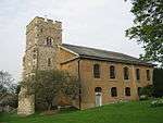 |
| Parish Church of St Mary | Strood | Parish Church | 1868-9 | 16 May 1991 | TQ7387469521 51°23′53″N 0°29′53″E / 51.398076°N 0.498071°E |
1121550 | 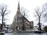 |
| Royal Victoria and Bull Hotel | Rochester | Courtyard | Late 18th century | 24 October 1950 | TQ7420968731 51°23′27″N 0°30′09″E / 51.390876°N 0.502494°E |
1086485 |  |
| South Block and attached Front Basement Area Railings, Brompton Barracks | Brompton | Barracks | Later alterations | 8 July 1998 | TQ7627569052 51°23′35″N 0°31′56″E / 51.393122°N 0.532317°E |
1375615 |
|
| South Tower House | Chatham Dockyard | House | c. 1718 | 13 August 1999 | TQ7599869044 51°23′35″N 0°31′42″E / 51.393136°N 0.528336°E |
1378601 |
|
| St Bartholomew's Chapel | Rochester | Chapel of Ease | 1952 | 29 October 1952 | TQ7524967892 51°22′59″N 0°31′01″E / 51.38302°N 0.517013°E |
1268238 |  |
| Stable, South Range and attached Wall to South | Chatham Dockyard | Wall | Early 18th century | 13 August 1999 | TQ7594268972 51°23′33″N 0°31′39″E / 51.392507°N 0.527496°E |
1378606 |
|
| Stables, North Range and attached Perimeter Wall | Chatham Dockyard | Boundary Wall | c. 1737 | 13 August 1999 | TQ7596068986 51°23′33″N 0°31′40″E / 51.392627°N 0.527761°E |
1378605 |
|
| Star Hill House with Railings to Front | Medway | House | Late 18th century | 24 October 1950 | TQ7459168061 51°23′05″N 0°30′28″E / 51.384741°N 0.50765°E |
1086408 |
|
| The Bell Mast | Chatham Dockyard | Bell Mast | Late C18/Early 19th century | 13 August 1999 | TQ7586168896 51°23′31″N 0°31′35″E / 51.391849°N 0.526295°E |
1378626 |  |
| The Customs House | Chatham Dockyard | Guardhouse | Early 19th century | 13 August 1999 | TQ7586969021 51°23′35″N 0°31′35″E / 51.39297°N 0.526472°E |
1378635 |  |
| The Gleanings with Railings to Rear West | Rochester | House | c. 1830 | 19 February 1970 | TQ7402968134 51°23′08″N 0°29′59″E / 51.385569°N 0.499618°E |
1326284 |
|
| The Guard House (cafe) | Chatham Dockyard | Cafe | 1999 | 13 August 1999 | TQ7585069018 51°23′35″N 0°31′34″E / 51.392949°N 0.526198°E |
1378621 |  |
| The Limes and attached Garden Wall to North | Rochester | House | Mid 19th century | 24 October 1950 | TQ7406768182 51°23′10″N 0°30′01″E / 51.385988°N 0.500187°E |
1086439 |
|
| The Royal Dockyard Church | Chatham Dockyard | Seamen's Church | 1808-1811 | 24 May 1971 | TQ7589768975 51°23′33″N 0°31′37″E / 51.392548°N 0.526851°E |
1268203 |  |
| The Vines | Rochester | Timber Framed House | Early 18th century | 24 October 1950 | TQ7435368202 51°23′10″N 0°30′15″E / 51.38608°N 0.504302°E |
1185370 |
|
| Timber Seasoning Store, North | Chatham Dockyard | Timber Seasoning Shed | 1771 | 13 August 1999 | TQ7611669363 51°23′45″N 0°31′49″E / 51.395965°N 0.530188°E |
1378617 |
|
| Timber Seasoning Store, South | Chatham Dockyard | Timber Seasoning Shed | 1771 | 13 August 1999 | TQ7608069313 51°23′44″N 0°31′47″E / 51.395527°N 0.529647°E |
1378619 |
|
| Wall Surrounding Garden to Rear of former Commissioner's House | Chatham Dockyard | Gate Pier | Mid/Late 19th century | 13 August 1999 | TQ7592669026 51°23′35″N 0°31′38″E / 51.392997°N 0.527293°E |
1378636 |
|
| 156 Eastgate & High Street | Eastgate, Rochester | Timber Framed House | 17th century | 24 October 1950 | TQ7448668288 51°23′13″N 0°30′23″E / 51.386812°N 0.506254°E |
1299474 |  |
| 12 and 14 High Street | Rochester | House | first 1/4 of 16th century | 24 October 1950 | TQ7419768748 51°23′28″N 0°30′08″E / 51.391033°N 0.50233°E |
1336127 |  |
| 168 Eastgate & High Street | Eastgate, Rochester | House | Mid 17th century | 24 October 1950 | TQ7450668259 51°23′12″N 0°30′23″E / 51.386545°N 0.506527°E |
1336136 |  |
| 83 High Street | Rochester | House | Late 17th century | 24 October 1950 | TQ7434668548 51°23′21″N 0°30′16″E / 51.38919°N 0.504372°E |
1116481 |  |
| 351 High Street | Rochester | House | Early 19th century | 2 December 1991 | TQ7514367929 51°23′00″N 0°30′56″E / 51.383385°N 0.51551°E |
1320136 | |
Notes
- ↑ The date given is the date used by Historic England as significant for the initial building or that of an important part in the structure's description.
- ↑ Sometimes known as OSGB36, the grid reference is based on the British national grid reference system used by the Ordnance Survey.
- ↑ The "List Entry Number" is a unique number assigned to each listed building and scheduled monument by Historic England.
External links
![]() Media related to Grade II* listed buildings in Kent at Wikimedia Commons
Media related to Grade II* listed buildings in Kent at Wikimedia Commons
This article is issued from Wikipedia - version of the 8/26/2016. The text is available under the Creative Commons Attribution/Share Alike but additional terms may apply for the media files.