Gongola State
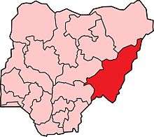
Location map of the Gongola State.
Gongola State is a former administrative division of Nigeria. It was created on 3 February 1976 from Adamawa and Sardauna Provinces of North-Eastern State, together with the Wukari Division of the then Benue-Plateau State; it existed until 27 August 1991, when it was divided into two states - Adamawa and Taraba. The city of Yola was the capital of Gongola State.
Gongola State was governed by an Executive Council.[1]
References
- ↑ "Gongola State of Nigeria Executive Council". Library of Congress Pamphlet Collection - Flickr. Retrieved 2014-05-11.
Coordinates: 8°30′N 11°45′E / 8.500°N 11.750°E
This article is issued from Wikipedia - version of the 5/11/2014. The text is available under the Creative Commons Attribution/Share Alike but additional terms may apply for the media files.