Pervomaisk, Mykolaiv Oblast
| Pervomaisk Первомайськ | |||
|---|---|---|---|
| City | |||
|
Skyline of Pervomaisk | |||
| |||
 Pervomaisk Location of Pervomaisk | |||
| Coordinates: 48°02′38″N 30°51′00″E / 48.04389°N 30.85000°ECoordinates: 48°02′38″N 30°51′00″E / 48.04389°N 30.85000°E | |||
| Country Oblast Municipality |
Ukraine Mykolaiv oblast Pervomaisk | ||
| Founded | 1676 | ||
| City status | 1773 | ||
| Government | |||
| • Mayor | Lyudmyla Dromashko | ||
| Area | |||
| • Total | 25.14 km2 (9.71 sq mi) | ||
| Population (2015)[1] | |||
| • Total | 66 733 | ||
| Postal code | 55200-55219 | ||
| Area code(s) | +380-5161 | ||
| Website | http://www.pervomaisk.mk.ua/ | ||


Pervomaisk (Ukrainian: Первома́йск Pervomajs'k) is a city in Mykolaiv Oblast, Ukraine and the administrative center of the Pervomaisk Raion. Administratively, the city is incorporated as a city of oblast significance and does not belong to the raion. It is located on the Southern Bug river which bisects the city. Population: 66,733 (2015 est.)[1] In 2001, population was 70,170.
Etymology
The name derives from the Russian pervomaj (первомай) meaning "the first of May," (May Day), referring also to the city's formation on 1 May 1919 from the merger of three neighbouring places.
The name for one of the merged towns, Bohopil (or Bogopol),[2] was derived from the name of a local river Southern Bug which in Polish is named Boh.
History
The city was formed when three neighbouring settlements: the village of Holta (Голта) and the town of Bohopil (Богопіль) around a county city of Olviopol (Ольвіополь) were merged. The merger was adopted by the All-Ukrainian Central Executive Committee on June 6, 1919. These cities existed from 1773 and the first settlement in the area was mentioned as early as 1676.
In the 17th century Holta was part of Zaporizhian Sich, Bohopil was the customs point of the Polish-Lithuanian Commonwealth and Olviopol was part of the Russian Empire.[3]
World War II
In World War II, Pervomaisk was occupied by the Axis Powers in 1941 and was divided between German occupation authorities on the east bank (Bohopol and Olviopol) and the Romanian-occupied region of Transnistria to the west (Holta). Holta served as the center of the Golta judeţ (district) of Transnistria. Pervomaisk had been more than 1/3 Jewish before the war but most were murdered during the occupation.
Remarkable buildings and structures
In Pervomaisk, there is at 48°4'0"N 30°51'29"E a 196 metres tall guyed TV mast, equipped with 6 crossbars running from the mast body to the guys.
Pervomaisk was the former location of the 46th Rocket Division of the 43rd Rocket Army of the Soviet Strategic Rocket Forces, formed during the Cold War.[4] One of the commanders of the division, appointed in 1991, was General Major Mikhail Filatov.[5] The RT-23UTTKh intercontinental ballistic missile silos based at Pervomaisk were destroyed, partially with Nunn–Lugar Cooperative Threat Reduction programme funding, during the 1990s.
Gallery
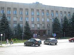 Pervomaisk city council
 Orthodox church of the Intercession of Our Lady in Pervomaisk
 Workers destroying a SS-24 silo at Pervomaisk
See also
References
- 1 2 "Чисельність наявного населення України (Actual population of Ukraine)" (PDF) (in Ukrainian). State Statistics Service of Ukraine. Retrieved 1 July 2016.
- ↑
- ↑ No Holds Barred, The Ukrainian Week (19 July 2013)
- ↑ Michael Holm, 46th Missile Division
- ↑ Woff, Armed Forces of the Soviet Union, B39-16
External links
- Official website of Pervomaisk (Ukrainian)
| Raions | |||||||
|---|---|---|---|---|---|---|---|
| Cities |
| ||||||
| |||||||