Goldsworthy, Western Australia
| Goldsworthy Western Australia | |
|---|---|
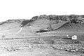
 1964 photograph showing iron ore outcrops on the top of Mount Goldsworthy before mining commenced | |
 Goldsworthy | |
| Coordinates | 20°20′31″S 119°31′16″E / 20.34194°S 119.52111°ECoordinates: 20°20′31″S 119°31′16″E / 20.34194°S 119.52111°E |
| Established | 1965 |
| Elevation | 46 m (151 ft) |
| Location |
|
| LGA(s) | Shire of East Pilbara |
| State electorate(s) | Pilbara |
| Federal Division(s) | Durack |
Goldsworthy (named after the geographical feature Mount Goldsworthy) is a former mining town in Western Australia east of Port Hedland and located in the Shire of East Pilbara. It was the first[1] iron ore mine in the Pilbara Region of Western Australia.
Early discoveries
The explorer Francis Thomas Gregory reported seeing iron ore in the region during his Pilbara explorations in late 1861[2] and the Government Geologist H.P. Woodward confirmed the discovery of iron ore there in 1890.[3] In 1919 Government Geologist Andrew Gibb Maitland confirmed these deposits but at the time mining them was not an economically viable proposition.[2]
In 1938 Geological Survey of Western Australia geologists Finucane and Telford surveyed Mount Goldsworthy and reported preliminary estimates of more than 6,000,000 tons of iron ore at 65.66%.[2] In the lead up to the Second World War, due to the classification of iron as a strategic material the Commonwealth of Australia placed an embargo on the export of ore. The export embargo was lifted in December 1960 and competition to develop the mine commenced in earnest with the government intending to issue an export licence for ore mined at the site.
Frank Thompson Jr, owner of Pardoo Station had established wells, windmills and paddocks in the area and also pegged mining leases there as they were on the southern end of the station, but he allowed these leases to lapse because of this embargo.
The granting of the export licence did not go without controversy. Ernie Mitchell, Chairman of Directors of an indigenous corporation known as the Pindan Group, called for an iron ore export licence to be issued to his organisation. Mitchell argued in a pamphlet issued in the early 1960s that:[4]
The granting of an export licence [for iron ore from Mount Goldsworthy] to us, the only successful self-contained Aboriginal group in Australia, would go a long way towards silencing the many critics of Australia's policy towards the original Australians.Furthermore: We do not ask for an export licence on terms different from those that would be applied to other persons or groups. We do ask that the following facts be considered:
- We are lifetime residents of the district.
- We have the mining skills, and the workforce necessary to handle the project.
- We are familiar with the problems that may arise, and have experience of solving such problems in recent years. We have been basically responsible for producing many thousands of tons of valuable minerals.
- We can make arrangements equivalent to those of any other sound business concern, and we have a pool of labour, resident in the district, and accustomed to working in the climactic and other arduous conditions of the Mount Goldsworthy area.
- We are aware, as all Australians should be, that our country’s policy in New Guinea towards the natives, and in Australia towards us, has been vigorously attacked in the councils of the United Nations Organisation ... We feel to grant us, the Aboriginal people of the Pindan Group, an iron ore export licence, would go a long way towards convincing such critics of our Government's sincerity and goodwill towards us, and would be a major contribution to the realisation of our plans to raise our standards to the level of our white fellow Australians by enterprise and hard work. We do not seek charity.
Early development of the mine
In February 1962, three international mining companies: the British-owned Consolidated Goldfields (Aust) Pty Ltd, Cyprus Mines Corporation of Los Angeles and Utah Development Co.[5] of San Francisco, formed Mount Goldsworthy Mining Associates (GML). The consortium was granted an export licence in early 1963 to ship 4 million tonnes of iron ore per year from a port to be built at Finucane Island at Port Hedland, 100 km west.
The consortium signed a contract with Japanese steel mills in February 1965 with a stipulation that the first shipment of ore had to me made within 15 months.
Construction of the port and town commenced in February 1965 and the first rail-delivery of iron ore was made to Finucane Island on 1 December 1965. The first 24,900 tonnes of ore was loaded at Finucane Island onto the Harvey S. Mudd on 26 June 1966.[6]
700 people lived in 200 houses at Goldsworthy at its peak. The mine at Goldsworthy was closed on 22 December 1982 and mining operations ceased at Shay Gap in 1993. The town was abandoned in 1992. Upon closure, all buildings were removed, all vegetation not indigenous to the local area was burnt and the roads torn up. This was done in accordance with the government's policy of regrowth to avoid the occurrence of ghost towns.[7][8]
Today, very little remains on the site to indicate that the town ever existed. The pit that was the mine still exists, but is flooded. The railway to other mines passes nearby, and there is a (solar powered) radio repeater site to service the railway. The street layout can still be seen from the air.
Climate
| Climate data for Goldsworthy | |||||||||||||
|---|---|---|---|---|---|---|---|---|---|---|---|---|---|
| Month | Jan | Feb | Mar | Apr | May | Jun | Jul | Aug | Sep | Oct | Nov | Dec | Year |
| Record high °C (°F) | 48.5 (119.3) |
47.8 (118) |
46.0 (114.8) |
43.1 (109.6) |
39.9 (103.8) |
34.3 (93.7) |
35.6 (96.1) |
37.7 (99.9) |
42.1 (107.8) |
44.4 (111.9) |
48.0 (118.4) |
47.1 (116.8) |
48.5 (119.3) |
| Average high °C (°F) | 39.6 (103.3) |
38.8 (101.8) |
38.7 (101.7) |
36.5 (97.7) |
31.6 (88.9) |
28.3 (82.9) |
28.0 (82.4) |
30.5 (86.9) |
34.3 (93.7) |
37.6 (99.7) |
39.5 (103.1) |
40.4 (104.7) |
35.3 (95.5) |
| Average low °C (°F) | 26.5 (79.7) |
26.3 (79.3) |
26.1 (79) |
23.8 (74.8) |
19.7 (67.5) |
16.6 (61.9) |
15.0 (59) |
16.5 (61.7) |
19.0 (66.2) |
21.5 (70.7) |
23.7 (74.7) |
25.3 (77.5) |
21.7 (71.1) |
| Record low °C (°F) | 20.5 (68.9) |
19.1 (66.4) |
18.9 (66) |
16.1 (61) |
12.2 (54) |
8.7 (47.7) |
6.9 (44.4) |
9.2 (48.6) |
12.2 (54) |
15.1 (59.2) |
16.3 (61.3) |
17.5 (63.5) |
6.9 (44.4) |
| Average precipitation mm (inches) | 67.6 (2.661) |
93.9 (3.697) |
57.9 (2.28) |
15.0 (0.591) |
23.1 (0.909) |
19.0 (0.748) |
9.8 (0.386) |
3.9 (0.154) |
1.3 (0.051) |
2.5 (0.098) |
2.3 (0.091) |
28.0 (1.102) |
329.7 (12.98) |
| Average precipitation days | 6.3 | 8.0 | 4.3 | 1.5 | 2.1 | 1.9 | 1.0 | 0.4 | 0.2 | 0.2 | 0.3 | 2.5 | 25.7 |
| Average relative humidity (%) | 35 | 37 | 32 | 24 | 27 | 27 | 22 | 21 | 17 | 19 | 21 | 27 | 26 |
| Source: [9] | |||||||||||||
Gallery
 Mount Goldsworthy from the GML exploration camp – Christmas 1963
 Original exploration camp. Note the addition of "Dongas" to accommodate extra staff during the "proving of reserves stage" in 1964.
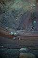 The pit looking eastwards in 1978
 The abandoned pit at Mount Goldsworthy in 2008
References
- ↑ Schubert, Leslie A.(1994), Wiping Out the Tracks – The Northern Odyssey: A Family Biography & Social Commentary, ISBN 0646178938.
- 1 2 3 Hardie, J 1981: Nor'westers of the Pilbara breed, Shire of Port Hedland, ISBN 0-9594155-0-5, p. 235
- ↑ "Towns that need to be remembered". GWN. 2009-08-31.
- ↑ Indigenous accumulation and the question of land in the Kimberley Region of Western Australia: PRE 1968-1975 by: Tony Smith, University of Western Sydney, accessed: 27 May 2010
- ↑ "Utah Development profit reflects Japanese price rise". Sydney Morning Herald. 11 Dec 1973. p. 20. Retrieved 2012-10-01.
- ↑ Hardie, J 1981: Nor'westers of the Pilbara breed, Shire of Port Hedland, ISBN 0-9594155-0-5, p. 247
- ↑ BHP Billiton Limited (3 October 2005). "Form 20-F – Annual Report pursuant to Section 13 or 15 (d) of the Securities Exchange Act of 1934 for the fiscal year ended 30 June 2005". New York Stock Exchange. Retrieved 3 Nov 2013.
- ↑ Federal Court of Australia (29 July 2010). "Brown (on behalf of the Ngarla People) v State of Western Australia (No 2) [2010] FCA 498". Jade 3.0. BarNetwork Pty Limited. Retrieved 3 Nov 2013.
- ↑ "Climate statistics for Goldsworthy, Western Australia". Bureau of Meteorology. Retrieved 9 June 2015.
External links
- Nicolas Rothwell, Memory is all we have, The Australian, 7 October 2006
- "Goldsworthy". Gazetteer of Australia online. Geoscience Australia, Australian Government.
- Bonzle map of Goldsworthy