Kalgoorlie
| Kalgoorlie Western Australia | |||||||
|---|---|---|---|---|---|---|---|
 Kalgoorlie Court House, Hannan Street | |||||||
 Kalgoorlie | |||||||
| Coordinates | 30°44′56″S 121°27′57″E / 30.74889°S 121.46583°ECoordinates: 30°44′56″S 121°27′57″E / 30.74889°S 121.46583°E | ||||||
| Population | 32,797 (2015)[1] (44th) | ||||||
| • Density | 436.71/km2 (1,131.1/sq mi) | ||||||
| Established | 1893 | ||||||
| Elevation | 468 m (1,535 ft) | ||||||
| Area | 75.1 km2 (29.0 sq mi)[2] (2011 urban) | ||||||
| Time zone | AWST (UTC+8) | ||||||
| Location | 595 km (370 mi) E of Perth | ||||||
| LGA(s) | City of Kalgoorlie–Boulder | ||||||
| State electorate(s) | Kalgoorlie, Eyre | ||||||
| Federal Division(s) | O'Connor | ||||||
| |||||||
Kalgoorlie, part of the City of Kalgoorlie-Boulder, is a city in the Goldfields-Esperance region of Western Australia, Australia, located 595 kilometres (370 mi) east-northeast of Perth at the end of the Great Eastern Highway. The town was founded in 1893 during the Coolgardie gold rush, and is located close to the so-called "Golden Mile". It is also the ultimate destination of the Goldfields Water Supply Scheme and the Golden Pipeline Heritage Trail.
At June 2015, Kalgoorlie (including Boulder), had an estimated urban population of 32,797.[1]
The name Kalgoorlie is derived from the Wangai word Karlkurla, meaning "place of the silky pears".[3]
History
In January 1893, prospectors Patrick (Paddy) Hannan, Tom Flanagan, and Dan O'Shea were travelling to Mount Youle when one of their horses cast a shoe. During the halt in their journey, the men noticed signs of gold in the area and decided to stay and investigate. On 17 June 1893, Hannan filed a Reward Claim, leading to hundreds of men swarming to the area in search of gold and Kalgoorlie, originally called Hannan's Find, was born.[4]
The population of the town was 2,018 (1,516 males and 502 females) in 1898.[5]
The mining of gold, along with other metals such as nickel, has been a major industry in Kalgoorlie ever since, and today employs about one-quarter of Kalgoorlie's workforce and generates a significant proportion of its income. The concentrated area of large gold mines surrounding the original Hannan's find is often referred to as the Golden Mile, and was sometimes referred to as the world's richest square mile of earth.
In 1901 the population of Kalgoorlie was 4,793 (3,087 males and 1,706 females) which increased to 6,790 (3,904 males and 2,886 females) by 1903.[6]
The 3 ft 6 in (1,067 mm) narrow-gauge Government Eastern Goldfields Railway line reached Kalgoorlie station in 1896, and the main named railway service from Perth was the overnight sleeper train The Westland which ran until the 1970s. In 1917, a 4 ft 8 1⁄2 in (1,435 mm) standard gauge railway line was completed, connecting Kalgoorlie to Port Augusta, South Australia across 2,000 kilometres (1,243 mi) of desert, and consequently the rest of the eastern states. The standardisation of the railway connecting Perth (which changed route from the narrow-gauge route) in 1968 completed the Sydney–Perth railway, making rail travel from Perth to Sydney possible; the Indian Pacific rail service commenced soon after. During the 1890s, the Goldfields area boomed as a whole, with an area population exceeding 200,000, composed mainly of prospectors. The area gained a notorious reputation for being a "wild west" with bandits and prostitutes. This rapid increase in population and claims of neglect by the state government in Perth led to the proposition of the new state of Auralia but, with the sudden diaspora after the Gold Rush, these plans fell through.
Places, famous or infamous, that Kalgoorlie is noted for include its water pipeline, designed by C. Y. O'Connor and bringing in fresh water from Mundaring Weir near Perth, its Hay Street brothels, its two-up school, the goldfields railway loopline, the Kalgoorlie Town Hall, the Paddy Hannan statue/drinking fountain, the Super Pit and Mount Charlotte lookout. Its main street is Hannan Street, named after the town's founder. One of the infamous brothels also serves as a museum and is a major national attraction.
Kalgoorlie and the surrounding district was serviced by an extensive collection of suburban railways and tramways, providing for both passenger and freight traffic.[7]
On 20 April 2010, Kalgoorlie was shaken by a an earthquake that reached 5.0 on the richter scale. The epicentre was 30 km north east of the town.[8] The quake caused damage to a number of commercial hotels and historic buildings along Burt Street in Boulder. The entire Burt St. precinct was evacuated until 23 April. Work in the Superpit and many other mines around Kalgoorlie was stopped. Two people suffered minor injuries as a result of the quake.[9]
On 26 February 2014, a magnitude 4.6 tremor once again struck the region. This quake was, however, less powerful and no reports of damage or injuries occurred.
On 30 August 2016, Kalgoorlie was the scene of a protest that turned violent over the death of Elijah Doughty, a fourteen-year-old Indigenous Australian who was killed in a crash with a utility vehicle while riding on a stolen motorcycle.[10] Several police officers were injured during the riot and at least ten people were charged.[11]

Industry and commerce
Kalgoorlie–Boulder is a regional centre and has a Chamber of Commerce[12] and a Chamber of Minerals and Energy.[13]
Mining
Since 1992, Kalgoorlie has been home to the Diggers & Dealers conference, held annually in August. It is Australia's premier international mining conference.[14]
It is also home to the Australian Prospectors & Miners' Hall of Fame.
Super Pit
The Super Pit is an open-cut gold mine approximately 3.6 kilometres (2.2 mi) long, 1.6 kilometres (1.0 mi) wide and 512 metres (1,680 ft) deep.[15] It was created by Alan Bond, who bought up a number of old mining leases in order to get the land area needed for the Super Pit. Occasionally the excavating has revealed an old shaft containing abandoned equipment and vehicles from the earlier mines.
The mine operates 24 hours a day, 7 days a week, and a visitor centre overlooks it. The mine blasts at 1:00 pm every day, unless winds would carry dust over the town. Each of the massive trucks carries 225 tonnes of rock and the round trip takes about 35 minutes, most of that time being the slow uphill haul. Employees must live in Kalgoorlie; it is not a fly-in fly-out operation. The mine is expected to be productive until about 2029.
-
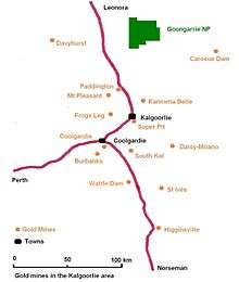
Gold mines in the Kalgoorlie region
-

The Super Pit that gives the mine its name appears in the centre of this image.
Culture
Kalgoorlie–Boulder has a dynamic and diverse cultural scene.[16][17]
Arts
Kalgoorlie–Boulder has many arts organisations and practising artists.[18]
Sports
Kalgoorlie–Boulder's location, being approximately 600 km from Perth, contributes to high levels of participation in Australian rules football, netball, basketball, rugby league, soccer, hockey and cricket. Other popular sports in Kalgoorlie include tennis, lawn bowls, roller derby, rugby union and swimming.
Kalgoorlie also has an international squash tournament held every year at the YMCA.
In a statewide sense, the semi-professional Goldfields Giants basketball team competes in the State Basketball League (SBL), and were SBL Champions in 2007 and 2008.
The Goldfields Titans play in the Western Australia Rugby League Harvey Norman Premiership state rugby league competition. Home games are at the Oasis playing fields on Saturday afternoons.
Horse racing is also very popular in the city, and Kalgoorlie–Boulder is home to the internationally recognised annual "Race Round".
Attractions
Kalgoorlie–Boulder – the largest settlement for many hundreds of kilometres, with many employees at the Super Pit – is the centre of the area's social life. Of particular interest is the Kalgoorlie–Boulder Racecourse, a horse racing venue. Also well known in the area are the Kalgoorlie Skimpies, ladies employed by each pub who walk around in their underwear or burlesque outfits to attract punters and who expect a fee in return.[19] There are two grass sports ovals in the area and a cinema showing recent international releases.[20]
Accommodation
Kalgoorlie has historical hotels still in operation:
- Broken Hill Hotel. Iconic venue in Boulder. Known as the best "local pub" in the region.
- Exchange Hotel, Kalgoorlie. Situated at Kalgoorlie's main intersection.
- Kalgoorlie Hotel. Situated opposite the Kalgoorlie town hall.
- Palace Hotel, Kalgoorlie. Situated at Kalgoorlie's main intersection.
- Piccadilly Hotel. Suburban pub north of the Kalgoorlie CBD.
- Recreation Hotel. Two storied hotel in Boulder.
Many hotels have been put to private use, including:
- Cornwall Hotel, Boulder, extensively damaged during 1934 riots[21][22]
- Mount Lyall (refurbished as a restaurant 2004, currently a Nando's restaurant)[23]
Hotels that have disappeared from the city include:
- Boulder Block (demolished 1991) (Removed due to Super Pit expansion. This pub had a mine shaft so underground workers could access it.)
- Commercial Hotel (burnt down 3 November 1978)[24]
- Fimiston Hotel (demolished February 1980)[25]
- Foundry Hotel (closed 2005 – damaged by fire 3 July 2008, deliberately lit on fire in 2009, Burnt to the ground 2012)
- Glendevon Hotel (burnt down 1986)
- Golden Eagle (The collapsed balcony of the Golden Eagle hotel on the corner of Lane and Wittenoom St in Boulder.)[26] Damaged by fire then demolished in 2012
- Home from Home Family hotel (burnt in the riots of 1934)
- Oriental Hotel (demolished July 1972)[27]
Suburbs

The Kalgoorlie–Boulder metropolitan area consists of the following suburbs:[28]
- Boulder
Known as the home of the Super Pit, it is one of Kalgoorlie–Boulder's historical suburbs featuring many buildings and landmarks dating as far back as 1882. It was once the central business district for the Town of Boulder, but since amalgamation with Kalgoorlie, it is now more of a historical local centre. Boulder has its own post office, town hall and many hotels along its main thoroughfare, Burt Street. A significant refurbishment has been commenced as part of the 'Royalties for Regions' initiative.
- Broadwood (aka – Hampton Heights)
A new housing suburb located next to the Kalgoorlie-Boulder Airport, which was recently expanded.
- Fairways
This area derives its name from the golf course that once occupied the area. It was released to provide affordable property to a growing population in Kalgoorlie–Boulder. Fairways features a private primary school, church, caravan park and small business.
- Golden Grove (formerly Adeline)
Adeline was originally constructed around 1970 by the State Housing Commission. The suburb was built on the "Radburn concept", with houses facing away from the street and common pathways linking homes. The area has been plagued by antisocial problems. In 2003, a significant urban renewal project, including the renaming of the suburb to Golden Grove and re-aligning of homes was commenced. The project has seen some success but has yet to fully eliminate antisocial problems within the area.[29]
- Hampton Heights
See Broadwood.
- Hannans
Located in Kalgoorlie's far north. Hannans was the first suburb to have its own independent shopping centre ("Hannans Boulevard") which includes a Coles Supermarket. The area also has a primary school and an 18-hole golf course. The original course was not formally grassed but was recently refurbished. Several surrounding golf clubs joined together to form one club known as 'The Goldfields Golf Club'. A dam has been constructed to service what is now a luxury grass golf course and club. Alongside the golf course project has been the development and release of Greenview estate. It lies on the western border of Hannans. This ongoing project has been designed as an environmentally friendly estate, and will eventually consist of over 2000 homes, apartments and facilities such as parks and schools. As one of Kalgoorlie's highest growth areas there has been a proposal for a new alternative route, out of the suburb onto the Kalgoorlie Bypass, to avoid traffic problems on the already heavily used Graeme Street which is a direct route to the city centre. Other developments include 'Karkurla Rise' and 'Karkurla View' which have added an additional 400 homes to the area.
- Central Kalgoorlie
The central business district. Hannan Street, named after Paddy Hannan, is the Kalgoorlie's main street and stretches The length of the suburb. The western side of the suburb consists of housing and some light industry. The eastern side contains retail chains, banks, the police station, court house, restaurants, hotels, tourist attractions, schools, university and TAFE.
- Lamington
One of Kalgoorlie's oldest suburbs. Much like other older suburbs, almost every street is parallel with Hannan Street in Central Kalgoorlie and are noticeably wide. It houses North Kalgoorlie Primary School, small businesses, a medical practices, a hotel, tavern and a non-maintained 18 hole golf course.
- Mullingar
Much smaller today than it originally was before the Super Pit expansion. It's located at the far east end of Lamington between the northern Goldfields railway and Goldfields Highway.
- O'Connor
Officially O'Connor is the south-east section of the suburb of Somerville. Much of the area is increasingly now known as O'Connor. It is home to a primary school, private high school Goldfields Baptist College and shopping facilities. It also houses the city's only recreation centre.
- Piccadilly[30]
A narrow suburb following Piccadilly street between Central Kalgoorlie and Lamington. It features the city's regional hospital, small businesses, a hotel, sporting arena and two grassed ovals.
- Somerville
Somerville marks the end of Great Eastern Highway that stretches between Kalgoorlie–Boulder and Perth. Much of the area is now referred to locally as O'Connor. Somerville contains residential area, schools, retail shops, light industry and some horse stables. In the past it also contained market gardens.
- South Kalgoorlie
Stretching from Boundary Street, Kalgoorlie to Holmes Street, Golden Grove and bordering with Central Kalgoorlie, O'Connor and Golden Grove. South Kalgoorlie is mostly residential but also contains the Kalgoorlie–Boulder Racecourse, schools, some light industrial and small businesses. The suburb was expanded in the mid-1990s to include a sub-division named 'Sport of Kings' on Maxwell Street, using a surplus of land from the racecourse.
- Victory Heights
A residential only subdivision within Fairways estate along Burt Street.
- West Kalgoorlie
Kalgoorlie's main industrial area. It is the first suburb as you approach Kalgoorlie on the Great Eastern Highway. It features the city's airport and small, medium and heavy industrial. Currently under expansion further west (ANZAC Drive Industrial Estate.)
- West Lamington
The western tip of Lamington was built in the 1980s. It includes one shop, sporting facilities and an arboretum nature reserve.
- Williamstown
The small existing area features mostly housing with one small primary school. It is also home to the Mount Charlotte mine shaft and Nanny Goat Hill. KCGM, owned by Barrick Gold and Newmont Mining, owner of the Super Pit to the south, has begun mining the Hidden Secret orebody, between 215 metres (705 ft) and 440 metres (1,440 ft) below the surface of Williamstown, using the Mount Charlotte shaft as access.[31]
Transport
Rail
The town is located on the main East-West rail corridor across Australia. the Transwa Prospector operates once to twice daily passenger train services from Kalgoorlie to Perth. The Indian Pacific train also stops here, operating weekly in each direction.
Buses
Town bus services are provided by TransGoldfields, there are three town routes as well as school services. Transwa also operates road coaches that service the town.
Air
Commercial air services connect Kalgoorlie–Boulder with Melbourne and Perth, operating out of the Kalgoorlie-Boulder Airport. Airlines that provide regular flights include Alliance Airlines, Qantas, QantasLink and Virgin Australia. There is a locally owned and operated charter company with a flight school, Goldfields Air Services.[32]
Road
Kalgoorlie is linked to Perth by the Great Eastern Highway, and is also on the Goldfields Highway.
Media
Radio
Radio Services available in Kalgoorlie:
- ABC Goldfields-Esperance: 6GF 648 AM \ 94.3 FM (Part of the ABC Local Radio Network)
- ABC Classic FM: 6ABCFM 95.5 FM;
- ABC Radio National: 6ABCRN 97.1 FM
- ABC Triple J: 6JJJ 93.5 FM \ 98.7 FM
- ABC News Radio: 6PNN 100.3 FM
- Hot FM, (Commercial Station) 6KAR: 91.9 \ 97.9 FM – Top 40 radio format
- RadioWest (Commercial Station) 6 kg: 981 AM \ 92.7 FM – Adult Contemporary / Classic Hits / Talk radio format
- Vision Radio Network 1431 AM : Community Narrowcast Station – Christian praise, worship music and talk.
- Tjuma Pulka (Media) Aboriginal Corporation : 96.3 FM (Aboriginal Community radio service)
- 6TAB Racing Radio – 88FM (LIVE broadcasts of Horse Racing, Greyhound Racing and Harness Racing, with talkback and music played at other times).
Television Television services available include:
- The Australian Broadcasting Corporation (ABC) – ABC, ABC2/KIDS, ABC Me, ABC News 24 (digital channels)
- The Special Broadcasting Service (SBS) – SBS, SBS Viceland, Food Network, NITV (digital channels)
- GWN7 (Golden West Network), an affiliate station of the Seven Network
- WIN Television, an affiliate station of the Ten Network
- West Digital Television, an affiliate station of the Nine Network (provided jointly by Prime Television and WIN Television)
The programming schedule is mainly the same as the Seven, Nine and Ten stations in Perth with variations for News bulletins, sport telecasts such as the Australian Football League and National Rugby League, children's and lifestyle programs and infomercials or paid programming.
GWN7 maintains a newsroom in the city. The GWN7 bureau provides coverage of the surrounding area for the station's nightly 30-minute news program, GWN7 News, at 5:30 pm on weeknights.
A Foxtel subscription television service is available via satellite.
Newspapers
The local newspaper for the Kalgoorlie–Boulder and Goldfields region is The Kalgoorlie Miner.
Newspapers from Perth including The West Australian and The Sunday Times are also available, as well as national newspapers such as The Australian and The Australian Financial Review.
Climate
Kalgoorlie has a semi-arid climate with hot summers and mild winters. The average annual rainfall is 260mm on an average of 68 days and, while the average rainfall is fairly evenly distributed throughout the year, there is considerable variation from year to year.
January is the hottest month with an average maximum temperature of 33.6 °C, but temperatures above 40.0 °C occur nearly once a week when hot, dry, north to northeasterly winds arrive. Such high temperatures are usually followed by a cool change from the south and occasionally with a thunderstorm.
By contrast, winters are cool, with July average maximum and minimum temperatures being 16.5 °C and 4.8 °C, respectively. Cold, wet days with a maximum below 12.0 °C occur about once every winter. The lowest maximum temperature recorded is 7.2 °C on 19 July 1961. Overnight temperatures fall below freezing about four times in a typical winter. Such events occur on clear nights following a day of cold southerly winds.
| Climate data for Kalgoorlie | |||||||||||||
|---|---|---|---|---|---|---|---|---|---|---|---|---|---|
| Month | Jan | Feb | Mar | Apr | May | Jun | Jul | Aug | Sep | Oct | Nov | Dec | Year |
| Record high °C (°F) | 46.5 (115.7) |
44.9 (112.8) |
44.5 (112.1) |
38.9 (102) |
33.4 (92.1) |
27.6 (81.7) |
28.7 (83.7) |
32.0 (89.6) |
36.8 (98.2) |
40.9 (105.6) |
42.9 (109.2) |
45.0 (113) |
46.5 (115.7) |
| Average high °C (°F) | 33.6 (92.5) |
32.1 (89.8) |
29.5 (85.1) |
25.2 (77.4) |
20.6 (69.1) |
17.5 (63.5) |
16.7 (62.1) |
18.6 (65.5) |
22.3 (72.1) |
25.8 (78.4) |
28.9 (84) |
31.9 (89.4) |
25.2 (77.4) |
| Average low °C (°F) | 18.2 (64.8) |
17.8 (64) |
16.0 (60.8) |
12.6 (54.7) |
8.7 (47.7) |
6.2 (43.2) |
5.0 (41) |
5.5 (41.9) |
8.0 (46.4) |
11.0 (51.8) |
14.0 (57.2) |
16.5 (61.7) |
11.6 (52.9) |
| Record low °C (°F) | 8.8 (47.8) |
8.5 (47.3) |
5.7 (42.3) |
1.7 (35.1) |
−1.8 (28.8) |
−3.0 (26.6) |
−3.4 (25.9) |
−2.4 (27.7) |
−0.6 (30.9) |
−1.0 (30.2) |
3.1 (37.6) |
5.5 (41.9) |
−3.4 (25.9) |
| Average precipitation mm (inches) | 23.6 (0.929) |
31.2 (1.228) |
24.0 (0.945) |
21.3 (0.839) |
26.5 (1.043) |
28.9 (1.138) |
24.9 (0.98) |
21.4 (0.843) |
14.0 (0.551) |
14.8 (0.583) |
17.8 (0.701) |
16.4 (0.646) |
264.8 (10.425) |
| Average precipitation days (≥ 0.2mm) | 3.9 | 4.5 | 4.3 | 5.3 | 7.1 | 8.7 | 9.2 | 7.5 | 5.6 | 4.3 | 4.1 | 3.8 | 68.3 |
| Source: [33] | |||||||||||||
Education
There are 10 primary schools, 4 high schools and 1 university in the Kalgoorlie–Boulder area.
Primary schools
- Boulder Primary School
- East Kalgoorlie Primary School
- Goldfields Baptist College (private)
- Hannans Primary School
- Kalgoorlie Primary School
- Kalgoorlie School of the Air
- North Kalgoorlie Primary School
- O'Connor Primary School
- Saint Joseph's Primary School (private)
- Saint Mary's Primary School (Kalgoorlie Catholic Primary School) (private)
- South Kalgoorlie Primary School
High schools
- Eastern Goldfields College (formerly the Eastern Goldfields Senior High School Senior Campus)
- John Paul College (formerly Prendiville College & Christian Bros. College (amalgamated)) (private)
- Kalgoorlie–Boulder Community High School (formerly the Eastern Goldfields Senior High School Middle School Campus)
- Goldfields Baptist College (Year 8–10) (private)
Universities
- Curtin University of Technology – Kalgoorlie Campus (includes the Western Australian School of Mines and Curtin VTEC; formerly Kalgoorlie College)
- University of Western Australia and University of Notre Dame Australia – Rural Clinical School of Western Australia
TAFE
- Central Regional TAFE
Notable people
- Matt Birney, former WA Leader of the Opposition[34]
- John Cornell, actor and movie producer, best known for playing Strop on The Paul Hogan Show.
- Rica Erickson, historian, botanist and author[35]
- Brian Hayes, British radio personality[36]
- Dean Kemp, former Australian rules footballer[34]
- Wallace Kyle, Air Marshall, last leader of RAF Bomber Command[37]
- Walter Lindrum, champion professional billiards player[38]
- Barry Marshall, Nobel Prize winner[39]
- Bob Marshall, champion billiards player
- Tim Rogers, singer/songwriter[40]
- Jenny Talia, singer/songwriter[41]
- Terry Walsh, field hockey striker and coach[42]
- Kevin Bloody Wilson, singer and comedian[43]
- Steve Johnston, speedway rider
- Michael Patrizi, V8 supercar driver
- Dean Fiore, V8 supercar driver
- Melissa Price, Liberal member for Durack
- Ron Manners, prominent ex local business person
- Wendy Duncan, Australian politician from Western Australia
- Elizabeth Truswell, is a former Chief Scientist at the Australian Geological Survey Organisation
Images
<gallery widths="190px" heights="180px""> Image:Kalgoorlie Exchange Hotel DSC04484.JPG|Exchange Hotel. File:Kalgoorlie Gold Mine.JPG|Gold Mine. Image:York Hotel, Kalgoorlie.jpg|York Hotel. Image:Kalgoorlie The Big Pit DSC04498.JPG|The Super Pit, Australia's largest open-cut gold mine. Image:Kalgoorlie Post Office Clock.jpg|The historical Kalgoorlie Post Office, soon to be Courthouse. Image:Kalgoorlie Judds Pub.jpg|The Kalgoorlie Hotel/Judds Pub. </gallery>
See also
- Auralia (proposed Australian state with its capital in Kalgoorlie)
- Yilgarn Craton
Notes
- 1 2 "3218.0 – Regional Population Growth, Australia, 2014-15: Population Estimates by Significant Urban Area, 2005 to 2015". Australian Bureau of Statistics. Australian Bureau of Statistics. 30 March 2016. Retrieved 12 September 2016. Estimated resident population, 30 June 2015.
- ↑ "2011 Census Community Profiles: Kalgoorlie - Boulder". ABS Census. Australian Bureau of Statistics. Retrieved 15 September 2016.
- ↑ Eastern Goldfields Historical Society, Kalgoorlie http://www.kalgoorliehistory.org.au/kalgoorlie.html Retrieved 4 July 2016
- ↑ Raymond Radclyffe, Wealth and Wildcats, Carlisle, Western Australia: Hesperian (1898, reprinted 2004), p.15.
- ↑ "Population of Western Australia". Western Mail. Perth, Western Australia: National Library of Australia. 22 April 1898. p. 23. Retrieved 28 May 2012.
- ↑ "West Australia". Kalgoorlie Western Argus. Western Australia: National Library of Australia. 9 June 1903. p. 32. Retrieved 27 March 2014.
- ↑ Railways and roads of Kalgoorlie Singleton, C.C. Australian Railway Historical Society Bulletin, March/April 1954 pp33-36/40-44
- ↑ "Government to help Kalgoorlie quake victims". ABC News. Australian Broadcasting Corporation. 20 April 2010. Retrieved 22 April 2010.
- ↑ Burke, Louise; O'Connell, Ronan; Pownall, Angela (20 April 2010). "Earthquake strikes Goldfields". Yahoo7. The West Australian. Retrieved 22 April 2010.
- ↑ Allan-Petale, David (30 August 2016). "Indigenous journalist blames Kalgoorlie riots on Facebook crime pages". WAToday. Fairfax Media. Retrieved 4 September 2016.
- ↑ Nicolas Perpitch; Courtney Bembridge (1 September 2016). "Elijah Doughty death: Seven people charged in aftermath of Kalgoorlie riots".
- ↑ http://www.kalgoorliecci.asn.au/
- ↑ http://www.cmewa.com/
- ↑ Diggers and Dealers 2010 – The Song Remains The Same ABC Rural, author: Babs McHugh , published: 2 August 2010, accessed: 26 October 2010
- ↑ Kalgoorlie Consolidated Gold Mines (2007). "The Super Pit – Frequently Asked Questions". Archived from the original on 12 March 2008. Retrieved 2 April 2008.
- ↑ Kalgoorlie-Boulder Pure Gold, Arts and Cultural Experience, 2015 http://www.kalgoorlietourism.com/Arts-Culture-Experience-Kalgoorlie
- ↑ ABC, The multicultural faces of Kalgoorlie-Boulder, 5th May, 2014, http://www.abc.net.au/local/stories/2014/05/05/3998198.htm.
- ↑ http://www.artgold.net.au/
- ↑ The Western Australian on a famous Skimpie retrieved 7 July 2012
- ↑ Link to Kalgoorlie cinemas schedules
- ↑ Le Souef, Leslie (1934), The Cornwall Hotel, Boulder owned by one of the Jordans best friends Jack Osmetti. Looted and destroyed by fire. This hotel will be well remembered by the Walsh, Pitman-Coulter, Treffene murder cases, retrieved 22 March 2012
- ↑ Damage to the Cornwall Hotel from riots, 1900, retrieved 22 March 2012
- ↑ "Nando's restaurants near Kalgoorlie".
- ↑ "Kalgoorlie Miner" Fire Guts Top Floor of Commercial. 4 November 1978. p1.
- ↑ Kalgoorlie Miner "Famous old Hotel being pulled down". 1 February 1980. p3.
- ↑ http://au.news.yahoo.com/thewest/galleries/a/-/article/7085110/image/1/kalgoorlie-earthquake/ Archived 5 October 2013 at the Wayback Machine.
- ↑ Kalgoorlie Miner "Oriental Hotel demolition starts amid protests". 29 June 1972. p1.
- ↑ Greater Perth street directory (54th ed.), Ausway Digital, 2012, retrieved 26 January 2014 The Melway Perth suburban map has a series of maps at the rear of Kalgoorlie suburbs K1 to K6, Western Australia. Dept. of Land Information (2006), Travellers atlas of Western Australia (9th ed.), Dept. of Land Information, ISBN 978-1-921048-13-5the travellers atlas has K2 to K7 – each of these map series are almost identical and show suburb boundaries.
- ↑ "HOMESWEST HOUSING, KALGOORLIE, ANTISOCIAL BEHAVIOUR" (PDF). Government Western Australia. 11 March 2003. Retrieved 14 July 2014.
- ↑ Aerial Surveys Australia; HRRC (1969), Aerial photograph of Kalgoorlie looking south west across the cemetery, the suburb of Piccadilly and the town, 18 Dec. 1969 [picture], retrieved 26 January 2014
- ↑ Lucas, Jarrod (16 July 2015). "Super Pit to reveal Hidden Secret". The West Australian. Perth, WA. Retrieved 26 May 2016.
- ↑ http://www.goldfieldsairservices.com/
- ↑ "Kalgoorlie climate statistics".
- 1 2 "KEMP, MR DEAN, RETIREMENT" (PDF). Western Australia Hansard. 23 August 2001. p. 2923. Retrieved 17 February 2008.
- ↑ "Rica Erickson". State Library of Western Australia. 1 September 2001. Retrieved 17 February 2008.
- ↑ "Brian Hayes". BBC Press Office. 1 June 2004. Archived from the original on 24 January 2007. Retrieved 17 February 2008.
- ↑ "Australian Dictionary of Biography". Kyle, Sir Wallace Hart.
- ↑ "Lindrum, Walter Albert (1898–1960)". Australian Dictionary of Biography:Online. Retrieved 17 February 2008.
- ↑ Helen Wolfenden (4 October 2005). "From Kalgoorlie ward to Nobel award". ABC Radio Goldfields Esperance WA. Archived from the original on 10 March 2008. Retrieved 17 February 2008.
- ↑ "George Negus Tonight:Tim Rogers". Australian Broadcasting Corporation. Retrieved 17 February 2008.
- ↑ Hunter, Brooke (2 July 2014). "Jenny Talia F.O.C.U.S. Interview". femail.com.au. Retrieved 29 August 2016.
- ↑ "Olympic Landcare Project". Kalgoorlie-Boulder Urban Landcare Group. Retrieved 17 February 2008.
- ↑ "WTF is Kev??". Kevin Bloody Wilson official site. Archived from the original on 29 August 2007. Retrieved 17 February 2008.
References
- Casey, Gavin and Mayman, Ted.(1964) The Mile That Midas Touched Rigby, Adelaide..
Further reading
- 100th anniversary of rail link (History of the Eastern Goldfields railway, officially completed on 1 January 1897, to the present, including introduction of the Prospector train on 29 November 1971) Kalgoorlie Miner 1 January 1997, p. 2
- Early Railways in the Kalgoorlie Area, Shepley, W.H. Australian Railway Historical Society Bulletin, November 1965
External links
![]() Kalgoorlie-Boulder travel guide from Wikivoyage
Kalgoorlie-Boulder travel guide from Wikivoyage
| Wikimedia Commons has media related to Kalgoorlie, Western Australia. |
- City of Kalgoorlie-Boulder official website
- Kalgoorlie Australia Travel Guide
- Kalgoorlie official tourism website