Gmina Moskorzew
| Gmina Moskorzew Moskorzew Commune | |||
|---|---|---|---|
| Gmina | |||
| |||
 Gmina Moskorzew | |||
| Coordinates (Moskorzew): 50°39′47″N 19°56′30″E / 50.66306°N 19.94167°E | |||
| Country |
| ||
| Voivodeship | Świętokrzyskie | ||
| County | Włoszczowa | ||
| Seat | Moskorzew | ||
| Area | |||
| • Total | 71.29 km2 (27.53 sq mi) | ||
| Population (2006) | |||
| • Total | 2,930 | ||
| • Density | 41/km2 (110/sq mi) | ||
| Postal code | 29-130 | ||
| Area code(s) | +48 34 | ||
| Car plates | TLW | ||
| Website | http://www.moskorzew.pl/ | ||

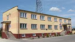
Building of the Commune Office
Gmina Moskorzew is a rural gmina (administrative district) in Włoszczowa County, Świętokrzyskie Voivodeship, in south-central Poland. Its seat is the village of Moskorzew, which lies approximately 22 kilometres (14 mi) south of Włoszczowa and 54 km (34 mi) south-west of the regional capital Kielce.
The gmina covers an area of 71.29 square kilometres (27.5 sq mi), and as of 2006 its total population is 2,930.
Villages
Gmina Moskorzew contains the villages and settlements of Chebdzie, Chlewice, Chlewska Wola, Dąbrówka, Dalekie, Damiany, Jadwigów, Lubachowy, Mękarzów, Moskorzew, Perzyny, Przybyszów and Tarnawa Góra.
Neighbouring gminas
Gmina Moskorzew is bordered by the gminas of Nagłowice, Radków, Słupia and Szczekociny.
References
| Seat |  | |
|---|---|---|
| Urban-rural gmina | ||
| Rural gminas | ||
This article is issued from Wikipedia - version of the 10/9/2013. The text is available under the Creative Commons Attribution/Share Alike but additional terms may apply for the media files.