Glomma
| Glomma / Glåma | |
| River | |
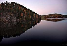 Glomma at Solbergfoss power plant, Østfold | |
| Name origin: Old Norse, Glaumr, from raumr: "noise," "racket" | |
| Country | Norway |
|---|---|
| Tributaries | |
| - left | Vorma |
| - right | Rena |
| Source | Aursund |
| - location | Røros, Sør-Trøndelag, Norway |
| - elevation | 690 m (2,264 ft) |
| - coordinates | 62°37′06″N 11°48′11″E / 62.61833°N 11.80306°E |
| Mouth | Fredrikstad |
| - location | Fredrikstad, Østfold, Norway |
| - elevation | 0 m (0 ft) |
| - coordinates | 59°13′04″N 10°55′51″E / 59.21778°N 10.93083°ECoordinates: 59°13′04″N 10°55′51″E / 59.21778°N 10.93083°E |
| Length | 621 km (386 mi) |
| Basin | 42,000 km2 (16,216 sq mi) |
| Discharge | |
| - average | 720 m3/s (25,427 cu ft/s) |
| - max | 4,700 m3/s (165,979 cu ft/s) |
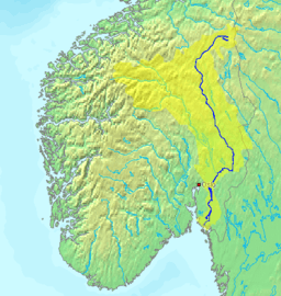 Glomma route | |
The Glomma, or Glåma, is the longest and largest river in Norway. The 621-kilometre-long (386-mile) river has a drainage basin that covers a full 13% of Norway's area, all in the southern part of the country.[1]
Geography

At its fullest length, the river runs from the lake Aursund near Røros in Sør-Trøndelag and runs into the Oslofjord at Fredrikstad. Major tributaries include the Vorma River, which drains Lake Mjøsa, joining the Glomma River at Nes. The Lågen drains into Lake Mjøsa, collecting drainage from the large Gudbrandsdal valley and significantly increasing the Glomma's flow.[2]
Because it flows through some of the richest forest districts, it has historically been Norway's leading log-floating river. The combination of raw materials, water power, and easy transport has over the centuries encouraged industry along the Glomma. Some of the country's largest manufacturing and processing concerns are found around its mouth, where supplies of timber and hydropower have been backed by excellent port facilities.
The upper limit of the Glomma valley farms is variable, but typically runs about 500 metres (1,600 ft) in Østerdalen, slightly lower than in Gudbrandsdal, which reflects the colder climate. The treeline, with a light birch forest, rises to about 900 metres (3,000 ft) in Østerdalen. Above Røros the forest is restricted to the valley floor.
The upper river valleys of Norwegian rivers have distinctive names which are vestiges of earlier cultural distinctions such as building styles, traditional clothing or bunad and domestic crafts. The upper valley of the Glomma is the Østerdal (or East Valley).
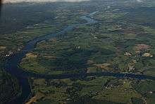
Upon entering Lake Øyeren at Fetsund, the Glomma has formed Europe's largest inland delta which reaches the opposite side of the lake, across its short axis. Some of the vast amount of silt that the Glomma deposits in Lake Øyeren is extracted to manufacture LECA building blocks widely used for in the construction of foundations in Norway.
Name
The form Glomma is used in Østfold and Akershus counties, while in Hedmark and Sør-Trøndelag counties the river is called (and written) Glåma. The old form was Glaumr which comes from raumr, meaning a "loud noise" or "thunder".
Several places are named after the river, for instance Glåmdal and Glåmos.
See also
- Category:Populated places on the Glomma River
References
- ↑ http://www.retten.no/lokale_nyheter/article6086600.ece
- ↑ Fullerton, Brian; Williams, Alan F. (1972). Scandinavia: An Introductory Geography. New York: Praeger Publishers.
External links
 Media related to Glomma at Wikimedia Commons