Glebe Island Bridge
| Blackbutts Bridge | |
|---|---|
 | |
| Crosses | Johnston's Bay |
| Followed by | swing bridge |
| Characteristics | |
| Material | Tasmanian blackbutt timber |
| Total length | 1,045 feet (319 m) |
| Width | 28 feet (8.5 m) |
| Longest span | 38 feet (12 m) |
| Number of spans | 27 |
| Glebe Island Bridge | |
|---|---|
 Glebe Island Bridge in a permanently open position | |
| Coordinates | 33°52′06″S 151°11′09″E / 33.86823116°S 151.18573072°ECoordinates: 33°52′06″S 151°11′09″E / 33.86823116°S 151.18573072°E |
| Carries | Bank Street |
| Crosses | Rozelle Bay |
| Locale | Rozelle – Pyrmont, New South Wales, Australia |
| Maintained by | Roads & Maritime Services |
| Heritage status | Australian Heritage Database (ID 15949) |
| Preceded by | Anzac Bridge |
| Followed by | Harbour Bridge |
| Characteristics | |
| Design | Swing bridge |
| Material | Steel |
| Total length | 353 feet 6 inches (107.75 m) |
| Width | 50 feet (15 m) |
| Height | 20 feet (6.1 m) |
| Longest span | 191 feet (58 m) |
| Number of spans | 3 |
| History | |
| Designer | Percy Allan |
| Constructed by | H McKenzie and Sons |
| Construction end | 1903 |
| Opened | 1 July 1903[1] |
| Closed | 2 December 1995 |
| Replaces | Timber bridge (1862–1903) |
The Glebe Island Bridge is a disused swing bridge over Rozelle Bay on Port Jackson, Sydney. The bridge, which connects Rozelle to Pyrmont by road, is one of the last remaining swing bridges of its type in Australia and in the world.
History
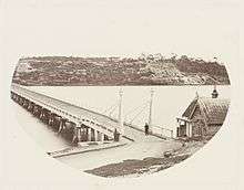
Work on the new Pyrmont Bridge and the bridge across Black Wattle Swamp shortened the travel distance to the inner west suburbs making it easier for produce to be conveyed to the city. A previously un-used part of Johnston's Bay was promoted as the site for a larger abattoir than the others previously used around the closer areas of high water. The new abattoir, to be opened in January 1860, was provided a punt system to cross the short distance to Pyrmont.[2] Work commenced on the first Glebe Island bridge in 1860.[3][4] This bridge opened for traffic in 1861.[5]
The Glebe Island Bridge was an electrically operated swing bridge opened on 1 July 1903,[6][7] the year after the opening of the new Pyrmont Bridge over Darling Harbour, which has a similar design. The bridge was designed by Percy Allan of the New South Wales Public Works Department who also designed the Pyrmont Bridge. During normal operation the two 29.1-metre (95 ft) swing spans rotated about a central vertical axis.
The bridge was closed on 2 December 1995, when the adjacent Anzac Bridge opened, and remains in a permanently open position with no access to pedestrians or vehicular traffic. The bridge was operated and used for access by cyclists in the annual Spring Cycle in October until 2008.
The bridge has been listed on the Australian Heritage Database since 1989.[8] A 2009 structural assessment found the bridge in "very poor condition" and in April 2013 a new report found that it had deteriorated further. City of Sydney Council and the community groups lobbied the state government to restore the structure and reopen the bridge for pedestrian and cyclists.[9] A cost–benefit report by ACIL Allen consultants for Transport for NSW on options for the bridge was released in September 2013.[10] In 2015, it was suggested the bridge could be reused to extend the Sydney Light Rail as part of the White Bay redevelopment.[11]
See also
References
- ↑ "Glebe Island Bridge". Office of Environment and Heritage. Retrieved 5 September 2015.
- ↑ "The Pyrmont Bridge Company's Road". Sydney Morning Herald. Sydney: National Library of Australia. 13 October 1859. p. 8. Retrieved 5 September 2015.
- ↑ "Commencement of the Glebe Island Bridge". Sydney Morning Herald. Sydney: National Library of Australia. 11 October 1860. p. 4. Retrieved 1 September 2015.
- ↑ "Commencement of the Glebe Island Bridge". The Sydney Mail. Sydney: National Library of Australia. 13 October 1860. p. 8. Retrieved 1 September 2015.
- ↑ "Country Works". The Sydney Mail. Sydney: National Library of Australia. 26 October 1861. p. 2. Retrieved 1 September 2015.
- ↑ "Glebe Island Bridge". Sydney Morning Herald. Sydney: National Library of Australia. 25 June 1903. p. 4. Retrieved 5 September 2015.
- ↑ "Glebe Island Bridge". Sydney Morning Herald. Sydney: National Library of Australia. 4 April 1903. p. 9. Retrieved 5 September 2015.
- ↑ "Glebe Island Bridge (Place ID 15949)". Australian Heritage Database. Department of the Environment.
- ↑ Nicole Hasham (3 April 2013). "Glebe Island Bridge is rotting away". Sydney Morning Herald. Retrieved 7 June 2013.
- ↑ "Options for Glebe Island: Cost–Benefit Analysis of various options for Glebe Island Bridge" (PDF). Transport for NSW. Government of New South Wales. 16 September 2013.
- ↑ Return of trams to Glebe Island Bridge floated in inner harbour overhaul Sydney Morning Herald 22 October 2015
External links
![]() Media related to Glebe Island Bridge at Wikimedia Commons
Media related to Glebe Island Bridge at Wikimedia Commons