Gleaner Heights
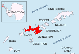


The Gleaner Heights (62°35′S 60°15′W / 62.583°S 60.250°W) are a series of elevations extending southwest from Leslie Hill in the eastern part of Livingston Island in the South Shetland Islands, Antarctica. They were named by the UK Antarctic Place-names Committee in 1958 after the American brig Gleaner, which was diverted to sealing in the South Shetland Islands in 1820–21.[1]
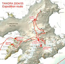
The first ascent was by the Bulgarian Doychin Vasilev from Camp Academia on 25 December 2004, as part of Tangra 2004/05 survey.
Location
The summit of the heights rising to 531 m is located at 62°34′25″S 60°13′59″W / 62.57361°S 60.23306°WCoordinates: 62°34′25″S 60°13′59″W / 62.57361°S 60.23306°W which is 5 kilometres (3 mi) north by west of Mount Bowles, 5.05 kilometres (3.14 mi) northwest of Melnik Peak and 1.43 kilometres (0.89 mi) west-southwest of Leslie Hill (British mapping in 1968, and Bulgarian in 2005 and 2009).
Maps
- L.L. Ivanov et al. Antarctica: Livingston Island and Greenwich Island, South Shetland Islands (from English Strait to Morton Strait, with illustrations and ice-cover distribution). Scale 1:100000 topographic map. Sofia: Antarctic Place-names Commission of Bulgaria, 2005.
- L.L. Ivanov. Antarctica: Livingston Island and Greenwich, Robert, Snow and Smith Islands. Scale 1:120000 topographic map. Troyan: Manfred Wörner Foundation, 2009. ISBN 978-954-92032-6-4
References
- ↑ "Gleaner Heights". Geographic Names Information System. United States Geological Survey. Retrieved 2012-04-26.
![]() This article incorporates public domain material from the United States Geological Survey document "Gleaner Heights" (content from the Geographic Names Information System).
This article incorporates public domain material from the United States Geological Survey document "Gleaner Heights" (content from the Geographic Names Information System).