Glarryford railway station
| Glarryford | |
|---|---|
|
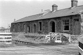
Glarryford station photographed on 10 June 1979 | |
| Location | |
| Area | County Antrim |
| Coordinates | 54°57′12″N 6°21′15″W / 54.9534°N 6.3543°WCoordinates: 54°57′12″N 6°21′15″W / 54.9534°N 6.3543°W |
| Operations | |
| Original company | Ballymena, Ballymoney, Coleraine and Portrush Junction Railway |
| Pre-grouping | Belfast and Northern Counties Railway |
| Post-grouping | Northern Ireland Railways |
| History | |
| 1 July 1856 | Station opens |
| 2 July 1973 | Station closes |
| Disused railway stations in the United Kingdom | |
|
Closed railway stations in Britain A B C D–F G H–J K–L M–O P–R S T–V W–Z | |
|
| |
Glarryford railway station served the area of Glarryford in County Antrim, Northern Ireland..
History
The station was opened by the Ballymena, Ballymoney, Coleraine and Portrush Junction Railway on 1 July 1856.[1] It was taken over by the Northern Counties Committee in January 1861.
The station closed to passengers on 2 July 1973.
| Preceding station | Following station | |||
|---|---|---|---|---|
| Cullybackey | Northern Ireland Railways Belfast-Derry |
Killagan | ||
| Historical railways | ||||
| Cullybackey Line and station open |
Ballymena, Ballymoney, Coleraine and Portrush Junction Railway Ballymena-Portrush |
Killagan Line open, station closed | ||
References
- ↑ "Glarryford station" (PDF). Railscot - Irish Railways. Retrieved 2012-04-29.
| Wikimedia Commons has media related to Glarryford railway station. |
This article is issued from Wikipedia - version of the 12/1/2016. The text is available under the Creative Commons Attribution/Share Alike but additional terms may apply for the media files.