Glödis
| Glödis | |
|---|---|
|
The Glödis from the south | |
| Highest point | |
| Elevation | 3,206 m (AA) (10,518 ft) |
| Prominence | 376 m ↓ Glödistörl |
| Isolation | 1.94 km → Roter Knopf (south arête) |
| Coordinates | 46°57′42″N 12°43′33″E / 46.96167°N 12.72583°ECoordinates: 46°57′42″N 12°43′33″E / 46.96167°N 12.72583°E |
| Geography | |
 Glödis | |
| Parent range | High Tauern, Schober Group |
| Climbing | |
| First ascent | 13 July 1871 by J. Pöschl with guides, Gorgasser and Hutter |
| Normal route | Klettersteig along the southeast arête (grade B) |
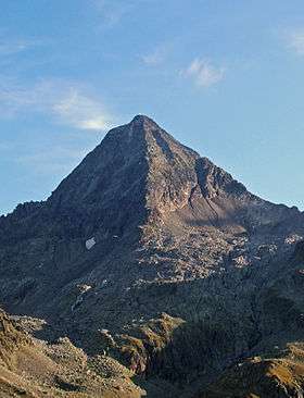

The Glödis (3,206 m (AA)) is one of the most regularly formed summits in the Schober Group in East Tyrol, hence its sobriquet, the "Matterhorn of the Schober Group". It is an impressive sight both from the Debanttal valley and the valley of Kalser Lesachtal.
Name
Franc Miklošič derives the name from the Slavic word gledna (= "seeing").[1] According to Heinz Pohl, however, there are 2 possible derivations: either from the early Slovenian glodišće (= "place gnawed away by water", from glodati = "to gnaw"), but this link is phonetically difficult; or more probably from glodež which has a similar meaning.[2]
In the Debanttal valley the mountain was for a long time called the Großer Gößnitzkopf. Its other names include Klöders and Granatkogel.[1]
Routes
The best ascent option is from the Lienzer Hut (1,977 m (AA)) along the Franz Keil Way, then on to the Kalser Törl and finally along the southeast arête. In autumn 2006 a klettersteig was installed on the southeast ridge which is of moderate difficulty (grade B). Other well known routes are:
- Southwest ridge from the Kalser Törl (II–III, in one place III+), popular, often used[3]
- Northeast ridge from Glödistörl (III-), boulder-strewn
- West ridge (IV–V), most difficult arête of the Glödis
- South ridge (III+), solid rock, rarely used
References
- 1 2 Walter Mair: Schobergruppe, Alpine Club Guide, Bergverlag Rudolf Rother, Munich, 1979. ISBN 3-7633-1222-6
- ↑ Mountain names according to Heinz Pohl. Retrieved 19 Feb 2015
- ↑ Zlöbl: Die Dreitausender Osttirols. p. 22, see literature
Literature and maps
- Alpine Club map Sheet 41, 1:25,000, Schobergruppe, ISBN 3-928777-12-2
- Richard Goedeke: 3000er in den Nordalpen, Bruckmann, Munich, 2004, ISBN 3-7654-3930-4
- Georg Zlöbl: Die Dreitausender Osttirols. Verlag Grafik Zloebl, Lienz-Tristach, 2005, ISBN 3-200-00428-2
External links
| Wikimedia Commons has media related to Glödis. |
- Österreichischer Alpenverein: Glödis Südostgrat. Ein Normalweg wird zum Klettersteig (pdf file; 300 kB)