Gibraltar, Michigan
| Gibraltar, Michigan | |
|---|---|
| City | |
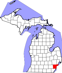
 Location in Wayne County and the state of Michigan | |
| Coordinates: 42°5′29″N 83°11′50″W / 42.09139°N 83.19722°WCoordinates: 42°5′29″N 83°11′50″W / 42.09139°N 83.19722°W | |
| Country | United States |
| State | Michigan |
| County | Wayne |
| Government | |
| • Mayor | Jim Gorris |
| Area[1] | |
| • Total | 4.41 sq mi (11.42 km2) |
| • Land | 3.78 sq mi (9.79 km2) |
| • Water | 0.63 sq mi (1.63 km2) |
| Elevation | 581 ft (177 m) |
| Population (2010)[2] | |
| • Total | 4,656 |
| • Estimate (2012[3]) | 4,584 |
| • Density | 1,231.7/sq mi (475.6/km2) |
| Time zone | EST (UTC-5) |
| • Summer (DST) | EDT (UTC-4) |
| ZIP code | 48173 |
| Area code(s) | 734 |
| FIPS code | 26-32020[4] |
| GNIS feature ID | 0626782[5] |
Gibraltar is a city in Wayne County in the U.S. state of Michigan. The population was 4,656 at the 2010 census.[6] It is located on the Detroit River directly south of, and adjacent to, Trenton.
History
The city is named after Gibraltar, a British Overseas Territory located on the southern end of the Iberian Peninsula at the entrance of the Mediterranean.[7]
Geography
According to the United States Census Bureau, the city has a total area of 4.41 square miles (11.42 km2), of which 3.78 square miles (9.79 km2) is land and 0.63 square miles (1.63 km2) is water.[1]
Demographics
| Historical population | |||
|---|---|---|---|
| Census | Pop. | %± | |
| 1960 | 2,196 | — | |
| 1970 | 3,842 | 75.0% | |
| 1980 | 4,458 | 16.0% | |
| 1990 | 4,297 | −3.6% | |
| 2000 | 4,264 | −0.8% | |
| 2010 | 4,656 | 9.2% | |
| Est. 2015 | 4,531 | [8] | −2.7% |
2010 census
As of the census[2] of 2010, there were 4,656 people, 1,946 households, and 1,283 families residing in the city. The population density was 1,231.7 inhabitants per square mile (475.6/km2). There were 2,217 housing units at an average density of 586.5 per square mile (226.4/km2). The racial makeup of the city was 94.7% White, 2.0% African American, 0.4% Native American, 0.7% Asian, 0.1% Pacific Islander, 0.6% from other races, and 1.6% from two or more races. Hispanic or Latino of any race were 2.9% of the population.
There were 1,946 households of which 29.2% had children under the age of 18 living with them, 48.2% were married couples living together, 12.4% had a female householder with no husband present, 5.3% had a male householder with no wife present, and 34.1% were non-families. 27.8% of all households were made up of individuals and 10% had someone living alone who was 65 years of age or older. The average household size was 2.39 and the average family size was 2.92.
The median age in the city was 41.4 years. 22% of residents were under the age of 18; 7.8% were between the ages of 18 and 24; 24.9% were from 25 to 44; 31.1% were from 45 to 64; and 14.2% were 65 years of age or older. The gender makeup of the city was 49.9% male and 50.1% female.
2000 census
As of the census[4] of 2000, there were 4,264 people, 1,728 households, and 1,225 families residing in the city. The population density was 1,109.1 per square mile (428.7/km²). There were 1,791 housing units at an average density of 465.9 per square mile (180.1/km²). The racial makeup of the city was 96.74% White, 0.52% African American, 0.33% Native American, 0.40% Asian, 0.59% from other races, and 1.43% from two or more races. Hispanic or Latino of any race were 1.83% of the population.
There were 1,728 households out of which 31.3% had children under the age of 18 living with them, 56.0% were married couples living together, 10.1% had a female householder with no husband present, and 29.1% were non-families. 23.3% of all households were made up of individuals and 5.5% had someone living alone who was 65 years of age or older. The average household size was 2.46 and the average family size was 2.89.
In the city the population was spread out with 23.5% under the age of 18, 7.9% from 18 to 24, 31.5% from 25 to 44, 28.2% from 45 to 64, and 8.9% who were 65 years of age or older. The median age was 38 years. For every 100 females there were 101.7 males. For every 100 females age 18 and over, there were 100.1 males.
The median income for a household in the city was $58,167, and the median income for a family was $67,457. Males had a median income of $53,750 versus $31,708 for females. The per capita income for the city was $28,528. About 1.9% of families and 2.7% of the population were below the poverty line, including 1.3% of those under age 18 and 3.2% of those age 65 or over.
Education
Public education is provided by the Gibraltar School District, serving all of Gibraltar, all of Rockwood, portions of Woodhaven, and portions of Brownstown Township. The school district operates these schools in Gibraltar:
- Parsons Elementary School
- Shumate Middle School
- Carlson High School
Notable person
References
- 1 2 "US Gazetteer files 2010". United States Census Bureau. Retrieved 2012-11-25.
- 1 2 "American FactFinder". United States Census Bureau. Retrieved 2012-11-25.
- ↑ "Population Estimates". United States Census Bureau. Retrieved 2013-06-03.
- 1 2 "American FactFinder". United States Census Bureau. Retrieved 2008-01-31.
- ↑ U.S. Geological Survey Geographic Names Information System: Gibraltar, Michigan
- ↑ "Race, Hispanic or Latino, Age, and Housing Occupancy: 2010 Census Redistricting Data (Public Law 94-171) Summary File (QT-PL), Gibraltar city, Michigan". U.S. Census Bureau, American FactFinder 2. Retrieved September 7, 2011.
- ↑ Gannett, Henry (1905). The Origin of Certain Place Names in the United States. Govt. Print. Off. p. 137.
- ↑ "Annual Estimates of the Resident Population for Incorporated Places: April 1, 2010 to July 1, 2015". Retrieved July 2, 2016.
- ↑ "Census of Population and Housing". Census.gov. Retrieved June 4, 2015.
External links

Municipalities and communities of Wayne County, Michigan, United States | ||
|---|---|---|
| Cities |
|  |
| Charter townships | ||
| General law townships | ||
| Unincorporated community | ||
| Footnotes | ‡This populated place also has portions in an adjacent county or counties | |
| Topics |  | |
|---|---|---|
| Detroit | ||
| Municipalities over 80,000 | ||
| Municipalities 40,000 to 80,000 | ||
| Cultural enclaves | ||
| Satellite cities | ||
| Counties in MSA | ||
| Counties in CSA | ||