Gibloux FR
| Gibloux | ||
|---|---|---|
| ||
 Gibloux | ||
|
Location of Gibloux  | ||
| Coordinates: 46°44′N 7°6′E / 46.733°N 7.100°ECoordinates: 46°44′N 7°6′E / 46.733°N 7.100°E | ||
| Country | Switzerland | |
| Canton | Fribourg | |
| District | Sarine | |
| Government | ||
| • Mayor | Syndic | |
| Area[1] | ||
| • Total | 36.06 km2 (13.92 sq mi) | |
| Elevation | 687 m (2,254 ft) | |
| Population (Dec 2015[2]) | ||
| • Total | 7,025 | |
| • Density | 190/km2 (500/sq mi) | |
| Postal code | 1695-6, 1726-8 | |
| SFOS number | 2236 | |
| Surrounded by | Autigny, Arconciel, Cottens, Hauterive, Le Glèbe, Pont-en-Ogoz | |
| Website |
http://www.commune-gibloux.ch SFSO statistics | |

Gibloux is a municipality in the district of Sarine in the canton of Fribourg in Switzerland. The municipality was formed 1 January 2016, from the merger of Corpataux-Magnedens, Farvagny, Le Glèbe, Rossens and Vuisternens-en-Ogoz.[3]
Heritage sites of national significance
The ruin of Illens Castle, the Chapel of Notre-Dame and the Church of Saint-Vincent are listed as Swiss heritage site of national significance.[4]
 Notre-Dame Chapel
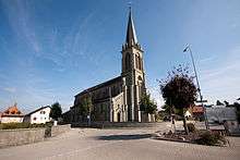 Saint Vincent Church
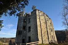 Illens Castle
References
- ↑ Arealstatistik Standard - Gemeindedaten nach 4 Hauptbereichen
- ↑ Swiss Federal Statistical Office - STAT-TAB, online database – Ständige und nichtständige Wohnbevölkerung nach institutionellen Gliederungen, Geburtsort und Staatsangehörigkeit (German) accessed 30 August 2016
- ↑ Amtliches Gemeindeverzeichnis der Schweiz published by the Swiss Federal Statistical Office (German) accessed 19 January 2016
- ↑ "Kantonsliste A-Objekte". KGS Inventar (in German). Federal Office of Civil Protection. 2009. Retrieved 25 April 2011.
External links
| Wikimedia Commons has media related to Gibloux. |
- Official website (French)
- Corpataux-Magnedens in German, French and Italian in the online Historical Dictionary of Switzerland.
- Corpataux in German, French and Italian in the online Historical Dictionary of Switzerland.
- Magnedens in German, French and Italian in the online Historical Dictionary of Switzerland.
- Farvagny in German, French and Italian in the online Historical Dictionary of Switzerland.
- Farvagny-le-Grand in German, French and Italian in the online Historical Dictionary of Switzerland.
- Farvagny-le-Petit in German, French and Italian in the online Historical Dictionary of Switzerland.
- Grenilles in German, French and Italian in the online Historical Dictionary of Switzerland.
- Posat in German, French and Italian in the online Historical Dictionary of Switzerland.
- Illens in German, French and Italian in the online Historical Dictionary of Switzerland.
This article is issued from Wikipedia - version of the 8/9/2016. The text is available under the Creative Commons Attribution/Share Alike but additional terms may apply for the media files.